Shaheed Dweep
Neil Island, officially known as Shaheed Dweep (meaning “Martyr’s Island”), is part of Ritchie’s Archipelago in the Andaman Islands. It falls under the South Andaman administrative district of the Indian union territory of Andaman and Nicobar Islands. The island is situated approximately 36 km northeast of Port Blair. The first thing that captivates you upon approaching Shaheed Dweep is the vibrant palette of colors that defines the island. Its soft, powdery white beaches contrast beautifully with the lush green vegetation covering the interior, creating a picture-perfect landscape.
Beneath the clear waters, coral reefs burst with colors—pink, purple, orange, and every shade in between. Snorkeling or scuba diving here is an unforgettable experience, as you swim among schools of tropical fish, their shimmering scales creating a dazzling underwater kaleidoscope.
History
Neil Island was originally named after British Brigadier General James Neill, who fought for the British East India Company during the Sepoy Mutiny of 1857.
In December 2018, the island was officially renamed Shaheed Dweep as a tribute to Netaji Subhas Chandra Bose. During his visit to Port Blair on 30 December 1943, Bose hoisted the Indian flag and declared the Andaman and Nicobar Islands liberated from British rule. He had also named Andaman Island as Shaheed and Nicobar Island as Swaraj.
Geography
Shaheed Dweep (Neil Island) is part of Ritchie’s Archipelago, situated between Swaraj Dweep and Rose Island. The island is relatively flat, and much of its land was historically used for paddy cultivation, leaving very little natural forest cover. Most of the remaining greenery is confined to the reserve forest in the island’s northwestern region. Due to the limited forest cover, Shaheed Dweep tends to be slightly warmer than nearby Havelock Island.
Also read- Ultimate Geevor Tin Mine: Discover Cornwall’s Epic Hidden Mining Treasure
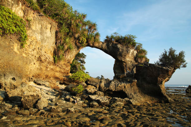
Natural Bridge, Neil Island
The Natural Bridge on Shaheed Dweep, popularly known as the Howrah Bridge, is a striking rock formation shaped by the sea over time. Located at Lakshmanpur Beach II, it is best seen during low tide, when visitors can walk across the exposed reef. This natural wonder is essentially an arch formed by two living coral formations growing together, creating a breathtaking and unique spectacle along the island’s coastline.
Things to do in Shaheed Dweep
Neil Island (Shaheed Dweep) is a paradise for nature lovers, offering a variety of outdoor activities to keep visitors entertained. The island boasts several stunning beaches, each with its own charm. Bharatpur and Sitapur beaches are ideal for swimming, sunbathing, or simply enjoying breathtaking sunsets. One of the island’s most striking sights is the natural rock formation known locally as the Howrah Bridge on Lakshmanpur Beach, a must-see for photographers and nature enthusiasts alike.
For those seeking adventure, Shaheed Dweep offers hiking and trekking through its dense interior forests, which are home to a rich diversity of flora and fauna. Rare species of birds and plants await discovery, while the gentle rustling of leaves and the melodic chirping of exotic birds create a serene and immersive experience for every trekker.
Also read- Geotourism And Modern Geotechniques
Neil Island Hotels
10 best hotels in Neil Island
How To Reach Shaheed Dweep
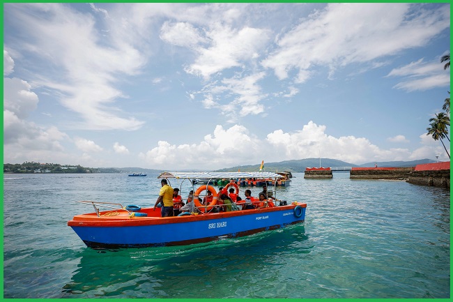
To reach Neil Island (Shaheed Dweep), travelers can take a ferry or cruise from Port Blair. The most common and convenient option is a private catamaran ferry, which takes approximately 1.5 to 2 hours. Government ferries are also available, though they are less frequent and take longer. Additionally, ferries from Havelock Island provide another route to Neil Island for those exploring multiple islands in the Andamans.


