Nonesuch Potholes, Michigan
The Nonesuch Potholes are distinctive, bowl-shaped geological formations sculpted into the Nonesuch Shale bedrock along the Presque Isle River in Michigan’s Upper Peninsula. Situated within Porcupine Mountains Wilderness State Park, these features were carved by the river’s powerful erosive forces, particularly near Manido Falls.
The Pothles are located in the Nonesuch Shale, a formation known for copper sulfide and native copper, dating back roughly 1.1 billion years. They are erosional features, specifically potholes carved into stone by strong river currents, not to be confused with road potholes. To see the best exposures, one can visit the Porcupine Mountains Wilderness State Park, which is located on the far west side of the Upper Peninsula, near Ironwood/Ontonagon.
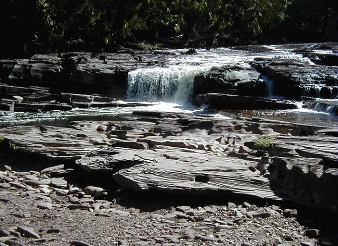
Manido Waterfalls
Manido waterfalls is a scenic 15–20 foot waterfall located on the Presque Isle River within the Porcupine Mountains Wilderness State Park. Known for its two-tiered drop and wide, cascading flow, it is a key feature of the Presque Isle Scenic Area near Lake Superior. The best time to visit the waterfall is Spring for peak flow; summer and fall for visiting the surrounding old-growth forests.
Also read- Sub-Torridonian Unconformity: A Stunning 2-Billion-Year Geological Time Gap
Geology
The Nonesuch Shale is a Proterozoic geologic formation exposed in Michigan and Wisconsin, United States, and extends in the subsurface as far southwest as Iowa, as revealed by drilling.
It consists of a lacustrine sequence of shale, siltstone, and sandstone, about 150–210 meters thick, lying conformably above the alluvial Copper Harbor Conglomerate and below the fluvial Freda Sandstone. Together, these units form the Oronto Group.
Dating to the Middle Proterozoic, around 1.1 billion years ago, the Nonesuch Shale was deposited during the development of the Midcontinent Rift and is notable for its abundance of organic carbon and pyrite.
Mineral resources
Copper was first identified in the Nonesuch Shale during the 1800s. In 1955, the Copper Range Company developed the White Pine Mine in the region. The copper was primarily extracted from chalcocite and native copper ores, and the underground operation continued producing from the Nonesuch Shale until its closure in 1995.
The Nonesuch Shale contains enough organic carbon (exceeding 0.5%) to be considered a potential petroleum source rock. Evidence of Precambrian oil has been observed seeping into the White Pine copper mine in Michigan. Exploration wells targeting Nonesuch-equivalent sediments in rift basins, but no commercially viable petroleum deposits have been found.
Also read- Geotourism And Modern Geotechniques
How to Reach Nonesuch Potholes, Michigan
The Nonesuch Potholes (Presque Isle River Potholes) are located along the Presque Isle River within the western side of Porcupine Mountains Wilderness State Park in Michigan’s Upper Peninsula. Access is best via the Presque Isle Scenic Area near Manido Waterfalls, which offers unique, water-carved rock formations best viewed during low water.
From the parking area, hike the scenic trails along the Presque Isle River. The potholes are best viewed by exploring the trails that lead along the riverbank near Manido Falls, a little upstream.


