Amazing White Sands National Park: A Largest Gypsum Dune Field

White Sands National Park

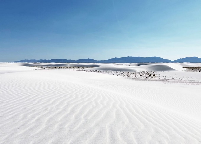
White Sands National Park is located in New Mexico and is surrounded by the White Sands Missile Range. This remarkable gypsum dune field is the largest of its kind on Earth, with an average depth of around 9.1 m, dunes rising as high as 18 m, and an estimated 4.1 billion metric tons of gypsum sand.

The brilliant white dunes occupy the northern part of the Chihuahuan Desert within a closed, internally drained basin known as the Tularosa Basin. The area ranges in elevation from about 3,890 to 4,116 feet above sea level.

The dune field covers roughly 275 square miles, of which about 115 square miles—around 40 percent—lie within the national park boundaries. The remaining portion extends onto nearby military land that is not accessible to the public.

This dune system is highly dynamic. Some of the most active dunes migrate toward the northeast at speeds of up to 30 feet per year, while dunes in more stable areas shift very slowly. The remarkably pure gypsum (hydrated calcium sulfate) that forms these dunes originates in the western part of the basin from a temporary lake, or playa, rich in dissolved minerals. As the water evaporates—sometimes at rates approaching 80 inches annually—the minerals are left behind, forming gypsum deposits that are later broken down and transported by wind to create the striking white dunes.

Despite the harsh environment of cold winters, hot summers, scarce surface water, and highly mineralized groundwater, many plants and animals have evolved specialized adaptations that allow them to survive in this unique desert ecosystem.

Location

White Sands National Park lies in southern New Mexico along the north side of U.S. Route 70, about 24 km southwest of Alamogordo and roughly 84 km northeast of Las Cruces. The park extends across western Otero County and northeastern Doña Ana County.

Also Read- Sub-Torridonian Unconformity: A Stunning 2-Billion-Year Geological Time Gap

Geology

During the Permian Period, shallow seas once covered the region that is now White Sands National Park in southern New Mexico. As these seas evaporated, they left behind thick deposits of gypsum (calcium sulfate). Later tectonic movements uplifted portions of this gypsum-rich seafloor, forming parts of the San Andres Mountains and the Sacramento Mountains.

White Sands National Park

Over time, rainfall dissolved the highly water-soluble gypsum in these mountains, and streams transported the dissolved minerals into the Tularosa Basin, a closed basin with no outlet to the ocean. The trapped water either seeped underground or collected in shallow pools that eventually evaporated, leaving gypsum behind on the surface in crystalline form known as selenite. Groundwater from the basin gradually flows southward into the Hueco Basin.

During the last Ice Age, a vast lake covering about 1,600 square miles—called Lake Otero—filled much of the basin. When the lake eventually dried up, it left behind an extensive flat layer of selenite crystals that today forms the area known as Alkali Flat.

Also read- Geotourism And Modern Geotechniques

Fossil Assemblage

Ice Age animals roamed the shoreline of an ancient lake that once covered the area now known as White Sands National Park thousands of years ago. Creatures such as the Columbian mammoth, the giant ground sloth, and the dire wolf walked along the muddy margins of Lake Otero, leaving deep footprints in the soft sediment.

Today, traces of their movements remain preserved in the sediments of Alkali Flat. These fossilized tracks, formed in layers of gypsum crystals, dolomite, and sand, can still be seen on the surface. Some of these ancient trackways stretch for as much as two miles, offering a remarkable record of prehistoric life in the region.

How to Reach White Sands National Park

The nearest air service is available at El Paso, Texas, located about 137 km away. White Sands National Park is situated about 15 miles southwest of Alamogordo along U.S. Route 70. The park is most conveniently reached by car, with its visitor center located between mile markers 199 and 200 on the highway. Currently, there is no public transportation that provides direct access to the park.


Related Posts

Incredible Salina Canyon Unconformity: Nature’s Dramatic Time Gap Exposed

The Salina Canyon Unconformity in central Utah is a spectacular, world-class geological feature along Interstate 70, where nearly vertical, red Middle Jurassic Twist Gulch Formation is capped by horizontal Paleocene Flagstaff Formation

Upheaval Dome: Stunning Crater, Synclines, and Ancient Rock

Upheaval Dome is a mysterious geological formation in San Juan County, Utah, USA, believed to be either a meteorite impact crater or a salt dome. It is located about 35 km southwest of Moab, within the Island in the Sky district of Canyonlands National Park.

Leave a Reply

Your email address will not be published. Required fields are marked *

You Missed

Mesmerizing Sand Mountain, Nevada: Experience the Magic of Singing Sands

Mesmerizing Sand Mountain, Nevada: Experience the Magic of Singing Sands

Incredible Salina Canyon Unconformity: Nature’s Dramatic Time Gap Exposed

Incredible Salina Canyon Unconformity: Nature’s Dramatic Time Gap Exposed

Upheaval Dome: Stunning Crater, Synclines, and Ancient Rock

Upheaval Dome: Stunning Crater, Synclines, and Ancient Rock

Flume Gorge: Ultimate Breathtaking Natural Wonder You Must Explore

The Stunning Wonders of Kimmeridge Bay: Jurassic Coast’s Shale wonder

The Stunning Wonders of Kimmeridge Bay: Jurassic Coast’s Shale wonder

Delaware Water Gap Adventure: Unveil a Spectacular Scenic Escape

Delaware Water Gap Adventure: Unveil a Spectacular Scenic Escape