Unforgettable Drumlins of Clew Bay: Ireland’s Stunning Glacial Wonder

Drumlins of Clew Bay

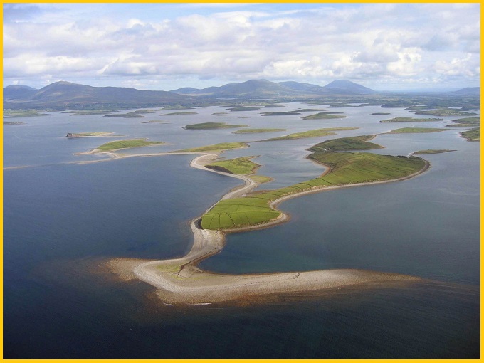
The drumlins of Clew Bay form a striking submerged landscape of 365 elongated, teardrop-shaped hills, shaped by glaciers during the last Ice Age and often called “one for every day of the year.” These islands are part of a “drowned” drumlin field created around 18,000–16,000 years ago, when ice sheets moved westward toward the Atlantic, leaving behind glacier-sculpted hills that now rise above the sea.

Geology

The drumlins are Quaternary in age, formed beneath an ice sheet that advanced from northeast to southwest during the peak of the last Ice Age. The bedrock surrounding Clew Bay consists of three main types: Carboniferous sandstones to the north, Carboniferous limestones in the central inner bay, and Silurian meta-sedimentary and meta-igneous rocks to the south. Notably, glacial landforms occur almost entirely in the Carboniferous limestone areas. Features such as Lough Furnace moraines and the Castlebar–Westport region are integral parts of this extensive drumlin field.

The classic “drowned” drumlin landscape illustrates how the sea has eroded a drumlin swarm formed during the second advance of ice in the last Ice Age. Nowhere else in Ireland matches its scale or the diversity of drumlin features.

Also read- Geotourism And Modern Geotechniques

Drumlin Islands

Clew Bay is characterized by numerous elongated drumlin islands and peninsulas aligned east–west along the inner coastline between Newport and Westport. Its eastern shore is bordered by a low-lying landscape underlain by Lower Carboniferous limestone.

There are numerous drumlin islands, many marked by west-facing cliffs and bordered by beaches, sand, and gravel shoals, formed from the erosion of drumlin slopes. In Clew Bay, these drumlins create an irregular coastline extending south to Lecanvey, where Thornhill Strand forms a curved sand-and-gravel beach. Hummocky moraines are widespread along the northern margins of the bay and around Lough Furnace. Many of the ridges of subglacial landforms are aligned southwest to northeast, reflecting an initial ice flow from the northeast toward the west and the offshore continental shelf.

Drumlins of Clew Bay

Glacial Landform

A drumlin is an elongated, teardrop-shaped hill formed by glacial activity, typically made of compacted sediment, clay, and rock known as glacial till. These streamlined landforms develop beneath moving ice sheets, with their long axis aligned in the direction of glacier flow, effectively preserving a snapshot of past ice movement.

Also read- Grassy Mountain Nonconformity: The 900-Million-Year Geologial mystery

In Ireland, as glaciers retreated, melting ice spread vast deposits of boulder clay across the landscape, especially over the central plain. Two main types of drumlins are recognized: till (or drift) drumlins and rock drumlins. Till drumlins consist of compact, unlayered glacial deposits, while rock drumlins have a solid rock core covered by a layer of drift. Rock drumlins generally allow better drainage than their till counterparts. Across Ireland, approximately 25,000 drumlins have been documented by the Geological Survey of Ireland.

How to Reach Drumlins of Clew Bay

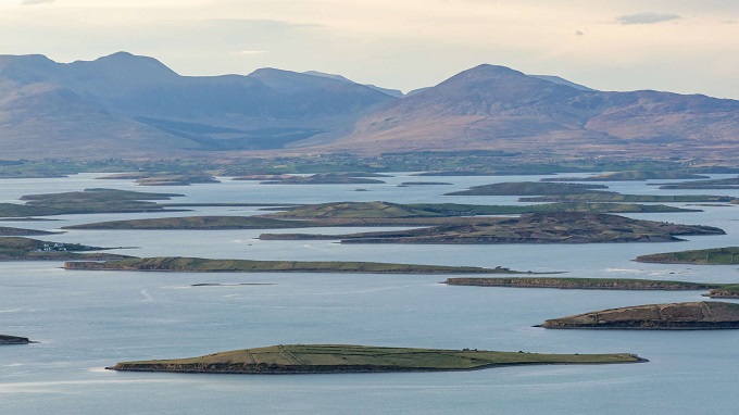
To reach the drumlins of Clew Bay in County Mayo, Ireland, travel to Westport or Louisburgh for scenic coastal views, or take a boat tour from Westport Quay (seasonal) for close-up views of the 365+ island archipelago. The best viewpoints are on the south side of the bay along the R335 road.

Related Posts

Pont d’Arc Adventure: Explore the Magnificent Natural Rock Bridge

Pont d’Arc is a natural stone arch located in the Ardèche département in southern France, about 5 km from the town of Vallon-Pont-d’Arc. Formed when the Ardèche River cut through a narrow escarpment in one of its meanders, the arch measures approximately 59 meters wide and 34 meters high.

Stunning Nagpatong Rock Formations: Breathtaking Views & Thrilling Hike

Nagpatong Rock Formation, located in Brgy. Cuyambay, Tanay, Rizal, features towering stacked limestone pillars rising to about 560 meters above sea level. The Nagpatong Rock Formation is a distinctive geological feature, including towering limestone pillars and rugged cliffs

Leave a Reply

Your email address will not be published. Required fields are marked *

You Missed

Pont d’Arc Adventure: Explore the Magnificent Natural Rock Bridge

Pont d’Arc Adventure: Explore the Magnificent Natural Rock Bridge

Stunning Nagpatong Rock Formations: Breathtaking Views & Thrilling Hike

Stunning Nagpatong Rock Formations: Breathtaking Views & Thrilling Hike

The Stunning Kundamala Potholes India: A Secret Geological Marvel

The Stunning Kundamala Potholes India: A Secret Geological Marvel

Bhaja Caves Adventure: The Magic of India’s Ancient Rock-Cut Caves

Bhaja Caves Adventure: The Magic of India’s Ancient Rock-Cut Caves

Ultimate Tracy Arm Fjord: A Breathtaking Glaciers & Hidden Wilderness

Ultimate Tracy Arm Fjord: A Breathtaking Glaciers & Hidden Wilderness

Paluxy River Tracks: The Dinosaurs and Human Footprints Mystery Revealed

Paluxy River Tracks: The Dinosaurs and Human Footprints Mystery Revealed