Roche-A-Cri Mound, Wisconsin
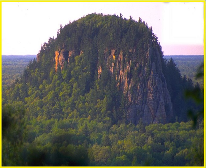
Roche-A-Cri Mound is a striking 91 m bluff, a resistant core left behind by a much larger expanse of Cambrian sandstone that has largely eroded over time. Between about 19,000 and 15,000 years ago, it stood as an island above Glacial Lake Wisconsin. Today, its summit is covered with red oak, black oak, white oak, red pine, white pine, and jack pine, while buzzards are often seen soaring overhead.
Roche-a-Cri is likely Wisconsin’s most striking and visually captivating rock formation—a bold, irregular outlier mesa of late Cambrian sandstone formed from the retreating Magnesian Escarpment. The name, derived by early French explorers, “Roche-a-Cri,” meaning “crevice in the rock,” refers to the prominent cleft visible from afar. The rock’s layered structure reveals evidence of three complete erosion cycles.
How the Rock Structure forms
Once an island rising from Glacial Lake Wisconsin, the formation is long and narrow, crowned by a flat ridge and edged with rugged cliffs. Its summit rises about 300 feet above the Central Sands plain, offering sweeping views of nearby Cambrian sandstone features such as Pilot Knob, Mosquito Mound, Rattlesnake Mound, and Dorro Couche. These pale, rocky formations stand out dramatically against the surrounding green landscape.
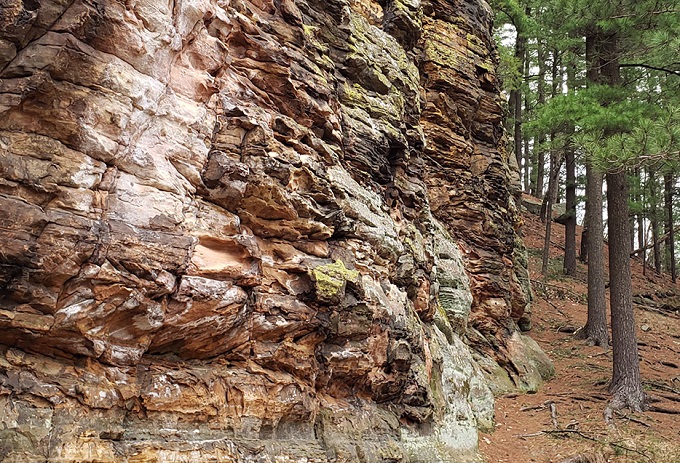
The summit supports a mix of red, black, and white oak, along with red, white, and jack pine. It also hosts plant communities typical of bracken grasslands, sand barrens, cliffs, dry forests, and prairies. Turkey vultures often use the high mound as a roosting site. Below, a steep talus slope leads to a narrow rock shelter that contains ancient rock art.
Also read-Beavertail Point, Rhode Island: A Breathtaking, Dramatic Cliffs and Scenic Ocean
Roche-A-Cri State Park
Roche-A-Cri State Park, established in 1948, preserves this sandstone mesa rock outcrop along with ancient Native American petroglyphs and pictographs. Its name, derived from French, means “screaming rock.” The park provides a range of recreational opportunities, including camping, picnicking, fishing, and hiking, with a stairway leading to the summit of the mound. Visitors can also view the petroglyphs and explore an informative wayside exhibit.
The park is centered around a 91 m rock outcrop that features Native American carvings known as the Roche-a-Cri Petroglyphs, along with a wooden stairway leading to the summit and over 8 km of scenic hiking trails. These petroglyphs are the only publicly accessible rock art site in Wisconsin. In addition, visitors can find other forms of rock art within the park, including a pictograph of a thunderbird and a depiction of a horned human figure.
Also read- Geotourism And Modern Geotechniques
How to Reach Roche-A-Cri Mound, Wisconsin
Roche-A-Cri State Park is located at 1767 State Highway 13 in Friendship, Wisconsin. Visitors can reach the summit by climbing a 303-step stairway that begins near the main parking area. The park is typically open from May through early October, with limited parking available during winter. A vehicle admission sticker is required for entry.


