
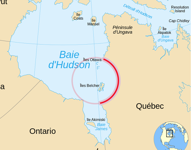
Nastapoka arc
The southeastern shore of Hudson bay forms a 155-degree curve, called the Nastapoka Arc in Quebec, Canada. Such a smoothly curved feature is not often found in nature and has prompted much geologic debate. The Arc appears nearly perfect circle of 450 Kilometers in diameter and traces the coast of Quebec on one side and grazes the Ontario shore on the other. The circular shape has led to suggestions that it represents an impact crater, However, there is no evidence for this hypothesis, and it is thought to have been formed as a result of lithospheric flexural during the Trans-Hudson orogeny.
This shoreline traces the boundary between two distinct groups of rocks. Onshore, the Superior Province Gneisses are hard metamorphic rocks that formed 3 billion to 2.7 billion years ago. Offshore lie the Nastapoka Group Supra crustal rocks, which formed during the early Proterozoic Eon, 2.5 billion to 1.6 billion years ago. These rock formations are part of the largest single belt of Archean-aged rocks in the world. (4 billion to 2.5 billion years ago.) They form the core of the Canadian Shield and the North American craton-the stable central core of the continent onto which other microcontinents’ landmass forms, as we know it today. This tectonic history is key to the prevailing theory for the arc’s formation.
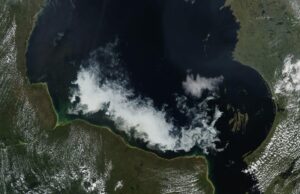
Nastapoka Arc location-Hudson Bay spans more than 1.2 million square Kilometers in northeastern Canada, just south of the Arctic Circle. It is the world’s second-largest bay, after the Bay of Bengal, and the site of various geologic puzzles.
How did Nastapoka arc form
Geologists believe the arc resulted from a continental collision-a 2-billion-year-old mountain-building episode known as the Trans-Hudson orogeny. As ancient continents collided, the crust buckled and fractured into slices that could thrust past each other to accommodate the compression. This formed a fold-and-thrust belt, the remnants of which are exposed today in the folds of the Belcher Islands. Farther to the east, where the Nastapoka Arc lies today, the collision produced a foreland basin. Gravity data collected in the early 1990s suggests the load placed on the crust by the fold-and-thrust belt could have caused the Center of the basin to sink, forcing up the edges, and resulting in the curvature.
Also, read- Dome-Shaped Spectacular Monolith in Uluru-Kata Tjuta National Park
Nastapoka arc impact crater
Other theories have also been put forth. In the late 1960s, Canadian astrophysicist Carlyle Beals suggested the arc could be the rim of an ancient impact structure, with the Belcher Islands representing the crater’s uplifted central peak. However, a field investigation in the 1970s turned up none of the usual evidence indicative of an impact, such as shocked quartz, radial fractures, melted rocks, or shatter cones.
Around the same time, another researcher suggested the shoreline was a scar marking where a continent had pulled apart or rifted. A nearby tectonic plate with a somewhat curved edge suggests it may have once fit together with the arc like two puzzle pieces. The debate continues today. In the mid-2000s, a researcher says that the curving shoreline of Hudson Bay could be an ancient impact crater that has been so reworked by geologic processes that the evidence of impact has been obscured.
Geology
The Nastapoka arc largely consists of Archean age rocks of the Superior craton. Generally, these rocks consist of about 60% Archean granitic Plutons and granitic gneiss. The granitic rocks include typically foliated Granodiorites, quartz diorites, Granite, and their metamorphosed equivalents. Some other occurrences are layered gneisses, migmatites and hybrid rocks that often form easterly trending linear belts. About 20% of the Superior craton consists of metamorphosed Archean volcanic and sedimentary rocks. They occur as tightly folded, metamorphosed, elongated to irregular, structural basins known as greenstone belts. The most abundant volcanic rock is metamorphosed basalts that exhibit, pillow lava, indicative of underwater volcanic eruptions. The metamorphosed sedimentary strata consist largely of interbedded mud stones and sandstones, exhibiting sedimentary structures indicative of turbidites.
Large triangular area surrounding Richmond Gulf, which includes a short segment of the Nastapoka arc, is underlain by about 1 kilometre of unreformed, feldspar-rich sandstone that is interbedded with minor beds of conglomerate and basaltic lava flows. These strata, which are known as the Richmond Gulf Group, rest Unconformably on Archean crystalline rocks of the Superior Craton. The graben, its faults, and the Richmond Gulf Group are unconformably overlain by the strata of the Nastapoka Group.
The portion of Hudson Bay immediately offshore of and partially encircled by the Nastapoka arc is underlain by the Early Proterozoic strata of the Nastapoka Group. Adjacent to the Nastapoka arc, these strata consist of metamorphosed sandstone, stromatolite-bearing dolomite, banded iron formation, and basalt.


