Moeraki Boulders
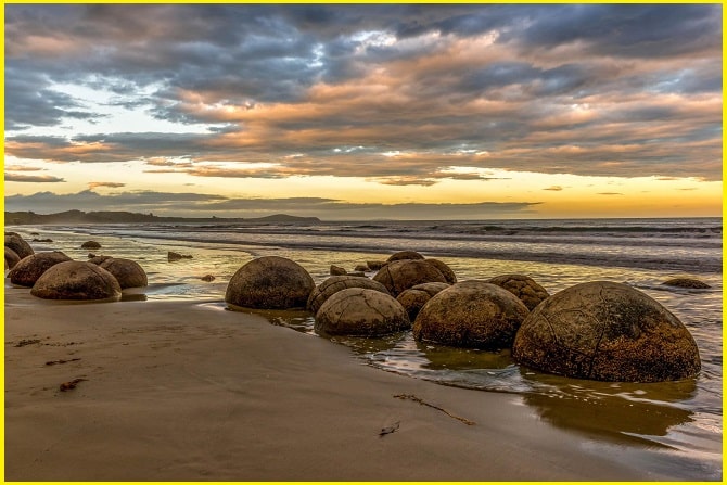
The Moeraki Boulders are a group of large spherical “stones” on Koekohe Beach near Moeraki on New Zealand’s Otago coast. The Moeraki Boulders are giant boulders that are highly spherical and were exposed due to erosion and wind. These boulders have been exposed through shoreline erosion from coastal cliffs. There are remaining boulders in the Mudstone that will, eventually, fall onto the beach as they come to lose due to erosion.
Moeraki boulders, New Zealand, are one of the most fascinating and popular attractions on the South Island. They originally started forming in ancient seafloor sediments around 60 million years ago, and the largest boulders are estimated to have taken about 4 million years to get to their current size.
How were the Moeraki Boulders Formed
The awesomeness of these giant geological mysteries of creation leaves many people wondering exactly what they are and how they formed. People sometimes mistake the Moeraki Boulders for dinosaur eggs, alien remnants, or evidence of giants.
According to scientists, the formation of these concretions began approximately 60 million years ago within the muddy Paleocene marine sediments of the Moeraki Formation. Each concretion began with an organic nucleus, “such as a leaf, cone, shell, fish-bone, or another relic of plant or animal”.
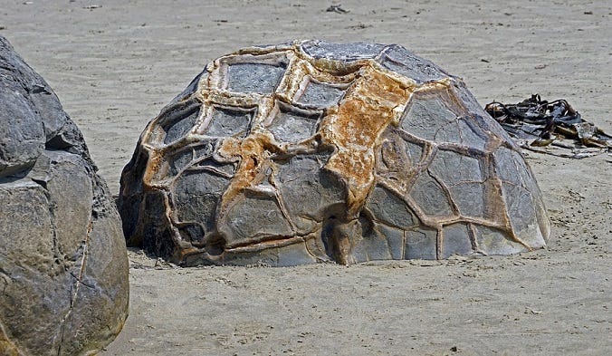
Sedimentary particles and minerals, such as calcite, aggregated around the organic matter in concentric layers. The process is similar to natural pearl forms around a foreign particle within an oyster. In a complex chemical process, the minerals cemented the particles together. The process continued, and the concretions grew slowly over millions of years.
Their spherical shape indicates that the source of calcium was mass diffusion, as opposed to fluid flow. The larger boulders, 2 meters in diameter, are estimated to have taken 4 to 5.5 million years to grow while 10 to 50 meters of marine mud accumulated on the seafloor above them.
Also Read- Frying Pan Lake, New Zealand’s Hidden Hot Spring Wonder
After the concretions formed, large cracks known as septaria formed in them. Brown calcite, yellow calcite, and small amounts of dolomite and quartz progressively filled these cracks when a drop in sea level allowed fresh groundwater to flow through the mudstone enclosing them.
Most of the Otago concretions are round, some of them almost perfectly, while others are more ovoid or slightly irregular in shape. They range in size from about 1.5 meters to a little over 2 meters. Variably, they lie clumped in groups or as individuals scattered across the beach.

Moeraki Boulders Beach
Moeraki Boulders Beach is a popular tourist spot in New Zealand known for its large, spherical boulders scattered across Koekohe Beach, located between the towns of Moeraki and Hampden. These ancient calcite concretions formed over millions of years and are exposed by coastal erosion, with scientific evidence suggesting they began forming around 60 to 65 million years ago. The beach is accessible via SH1, and visitors can view the boulders at low tide to best appreciate their size and detail.
Read- Geotourism And Modern Geotechniques
Moeraki Boulders Accommodation
Based on a search for accommodation near the Moeraki Boulders, here are some options available for a one-night stay.
Source-Historic mysteries, NewZealand.com


