Landmannalaugar
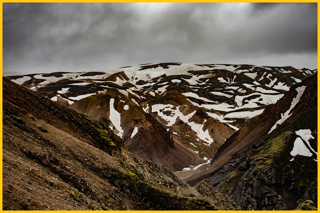
Landmannalaugar, located within Iceland’s Fjallabak Nature Reserve in the Highlands, lies at the edge of the Laugahraun lava field, which was created by an eruption around 1477. The area is renowned for its natural geothermal hot springs and striking volcanic landscapes. It also marks the northern starting point of the famous Laugavegur hiking trail, where the Iceland Touring Association operates a mountain hut that provides accommodation for hikers. Landmannalaugar is notable for its rich deposits of rhyolite, obsidian, and rhyolite lava, which give the landscape its striking colors and distinctive character.
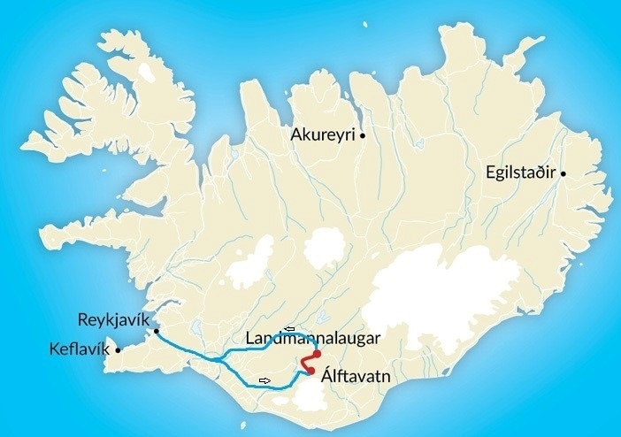
Landmannalaugar Map
Below is a map of Landmannalaugar with key points of interest. The map can be expanded to view driving directions to the area.
Landmannalaugar Weather
The weather in Landmannalaugar is highly unpredictable, marked by cool, windy, and often wet conditions throughout the year. Summer temperatures average around 10°C, while winters are much colder, frequently dropping below freezing. Owing to its high-altitude location in Iceland’s interior highlands, the area is prone to rapid shifts in weather, with clear skies quickly giving way to rain or even snow—even in the middle of summer.
Cool Temperatures:
In summer, daytime highs average around 10°C with lows near 5°C. Winters are much colder, with daytime highs around -2°C and lows dropping to about -8°C.
Wind:
Strong winds are frequent in this exposed highland environment, adding to the chill.
Precipitation:
Rain and other forms of precipitation are common throughout the year, so visitors should be prepared for consistently wet conditions.
Also Read- Ward’s Lake: Shillong’s Scenic Retreat
Landmannalaugar Hike
Landmannalaugar is famous for its diverse hiking trails. Popular routes include a walk through the Laugahraun lava field leading to Brennisteinsalda (“Sulphur Wave”), a one-hour ascent of Bláhnjúkur (“Blue Peak”), and a four-hour hike to the striking Ljótipollur crater lake (“Ugly Puddle”). The area also serves as a starting point for several longer treks, such as the Hellismannaleið trail at the base of Mount Hekla, and the Sprengisandur route, which crosses Iceland’s vast volcanic desert.
During the summer, visitors can enjoy Icelandic horse riding in the Landmannalaugar area, with trips leading to places such as Jökulgil (Glacier Valley), a location often difficult to reach on foot and inaccessible by car. Arctic char fishing is also popular in Landmannalaugar and the surrounding lakes. The region’s geothermal hot springs are open to the public for bathing, while in winter, the landscape transforms into a destination for cross-country skiing.
Landmannalaugar Camping
Planning to spend the night in Landmannalaugar? Camping here is an excellent way to enjoy the natural surroundings at your own pace fully. Visitors can choose between staying in the mountain hut or setting up a tent or camper at the nearby campsite. The Landmannalaugar campsite has designated tent areas with stunning views of the surrounding mountains—perfect for travelers who want to stay close to nature. The site is located near the service cabin with access to toilets and showers. Since the ground is gravel, pitching tents can be challenging. To help secure tent pegs, crates of rocks are provided. Visitors are asked to return the rocks to their designated place when departing.
Landmannalaugar Hot Spring
One of the highlights of Landmannalaugar is its natural geothermal hot spring, located near the campsite and mountain hut. Surrounded by lava fields and colorful rhyolite mountains, the warm waters provide a perfect spot to relax after a long hike. The spring is freely accessible to the public, though it can get busy during peak summer months, so arriving early or later in the evening often ensures a quieter experience.
How to Reach Landmannalaugar, Iceland
To reach Landmannalaugar, visitors can drive a rental 4×4 along the designated F-roads of the Fjallabak Nature Reserve, open only during the summer season (mid-June to mid-September). Alternatively, specialized Highland buses operate from Reykjavík, and guided options such as super jeep tours or package tours are also available. The summer months are considered the best time to visit, as this is when the F-roads are accessible.


