Saint Kitts and Nevis
Saint Kitts and Nevis, officially known as the Federation of Saint Kitts and Nevis, is a Caribbean nation comprising two islands—Saint Kitts and Nevis—situated in the Leeward Islands of the Lesser Antilles. Covering 261 square kilometers with a population of about 48,000, it is the smallest sovereign state in the Western Hemisphere by both area and population, and the world’s smallest sovereign federation. The country is a Commonwealth realm with King Charles III as its head of state.
Geography
The capital city, Basseterre, is situated on the larger island of Saint Kitts and serves as the main port for cruise ship passengers and cargo. Nevis, the smaller island, lies about 3 km southeast of Saint Kitts, across a shallow channel known as The Narrows. Nearby islands include Sint Eustatius, Saba, Saint Barthélemy, Saint-Martin/Sint Maarten, and Anguilla to the north-northwest; Antigua and Barbuda to the east and northeast; and Montserrat and the uninhabited Redonda to the southeast.
The federation consists of two primary islands, Saint Kitts and Nevis, separated by The Narrows strait. Both islands are of volcanic origin, featuring central peaks covered in tropical rainforest, while most of the population resides in the flatter coastal areas. Saint Kitts is home to several mountain ranges—the North West Range, Central Range, and South-West Range—with Mount Liamuiga, the country’s highest point, rising to 1,156 meters.
National Parks
St. Kitts and Nevis are home to two national parks: Brimstone Hill Fortress National Park and Central Forest Reserve National Park. Brimstone Hill Fortress was designated a national park in 1985 and recognized as a UNESCO World Heritage Site in 1999. The Central Forest Reserve was declared a national park on October 23, 2006, and officially gazetted on March 29, 2007.
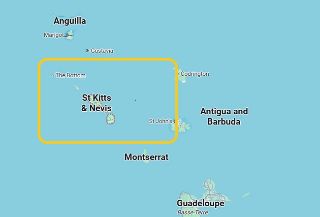
Saint Kitts and Nevis Map
Saint Kitts and Nevis, Nevis is cone-shaped with a central volcanic peak, Nevis Peak. The island features a narrow coastal plain that gradually rises to higher elevations and is fringed with both white and black sand beaches. St. Kitts, by contrast, is shaped like an elongated oval with a long, narrow peninsula extending southeast. Its coastal plain rises steeply toward a series of volcanic peaks, the tallest being Mount Liamuiga—formerly known as Mount Misery—a dormant volcano reaching 1,156 meters in height.
Saint Kitts and Nevis 10 day Itinerary
Explore the Capital:
Located on the central island of Saint Kitts, Basseterre is a welcoming, laid-back town perfect for a leisurely morning walk. Stroll past its charming colonial-era architecture and visit key landmarks such as St. George’s Anglican Church, Independence Square, the National Museum, and the vibrant Rosie Cameron Art Gallery.
Visit Brimstone Hill Fortress:
Located on the island’s northern end, this impressive site is a must-see as you drive west along the scenic coastal road through charming villages. Brimstone Hill Fortress National Park, a UNESCO World Heritage Site, dates back to the 1690s and offers a fascinating glimpse into the island’s colonial history. Don’t forget to grab an audio guide and map at the entrance to enhance your visit.
Caribbean Sea Meets the Atlantic Ocean:
At the northern end of the island, take in the stunning panorama from Gibbons Hill, where you can admire vibrant fishing boats along Dieppe Bay and the striking reef marking the meeting point of the Caribbean Sea and the Atlantic Ocean.
Dieppe Bay Lunch Break:
After exploring the foothills of Mount Liamuiga, take a break in Dieppe Bay for a true taste of local flavor. Seafood is the highlight here—stop by Reef Bar, a laid-back favorite, for freshly caught lobster, or try a delicious grilled wahoo sandwich at Arthur’s.


