Danxia Mountain
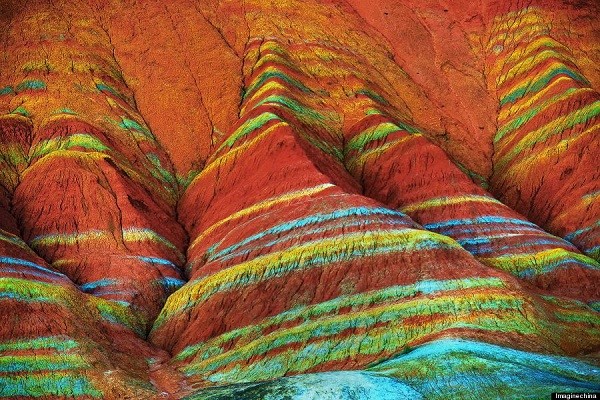
The Danxia mountains, or Rainbow Mountains, are a unique type of petrographic geomorphology found in China. The landscapes found in southeast, southwest, and northwest China consist of a red bed characterized by cliffs. Zhangye Danxia Landform is majestic and imposing, together with unusual shapes and gorgeous colours, making people stunned by the creation of nature. Danxia landform is formed from red-coloured sandstones and conglomerates of largely Cretaceous age. In a circumference of more than 10 square kilometres of Danxia Mountains, there are bright colours such as red, yellow, orange, green, white, graphite, and gray that can be seen everywhere, decorating the numerous trenches and hills colourfully. Zhangye Danxia landform’s bedding staggered lines, colourful tunes, and dazzling splendour form a colourful fairy tale world.
Zhangye Danxia Mountains are mainly divided into two parts, the north and south groups, echoing each other. The north mountain form is low and flat, mainly in red and white and red ocher tones. The South group takes away from the Zhangye urban area of about 40 to 50 km. The South Mountains landform is relatively steep and is amazing for its bedding stretches, clear texture, and colours.
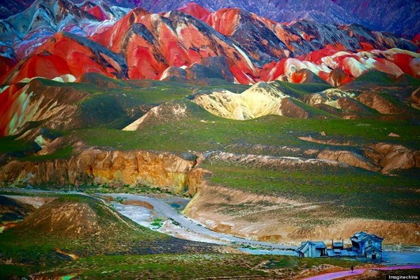
The Danxia Mountains formations were shaped into flowing valleys after thousands of years of rain and wind, and the region has been listed as a UNESCO World Heritage site. The geology can be seen at Danxiashan Geopark, where there are about 290 square kilometres of streams, forest, and towering Danxian rock formations exposed.
Danxiashan Geopark
Danxiashan UNESCO Global Geopark is the Redstone Park, located in the northeast of Shaoguan City in Guangdong Province, and has a total area of 290 km2, about half of which is densely covered by ‘Danxia landform’. Danxiashan Geopark became a UNESCO Global Geopark in 2004. The area was formed in a basin by fluvial deposition around 140-65 million years ago. The Danxiashan Geopark is characterized by multi-layered red sedimentary rocks of sandstone and conglomerate.
Also Read- Yangshuo: China’s Scenic Gem of Karst Mountains and Rivers
The area bears rock outcrops of different geological periods from the Sinian, Paleozoic, Mesozoic, to Neozoic. The Cretaceous sedimentary strata that form the present landscape are particularly important for studying dinosaur extinction, life, mammal evolution, and regional stratigraphical correlation. Danxiashan Geopark also has great natural aesthetic value because of its rivers (Jinjiang and Zhenjiang), red peaks (Yangyuanshi, Zengmaofeng), cliffs (Chahufeng, Guanyinshi), caves (Longlinyan), canyons and valleys (Bazhai).
How the Danxia Mountains form
Geologists believe that Danxia topography is formed by the folding of layered oceanic crust. Layered horizontal and flat sandstone stratigraphy of Rainbow Mountains got uplifted and exposed rocks that were otherwise hidden well below the surface of the earth. Weathering and erosion removed the overlying layers of continental siliciclastic rocks and exposed underlying formations with different mineralogy and chemistry. This causes the striking variation in colours seen across the Danxia Mountains. Exposed slanting rock layers have different colours, textures, shapes, sizes, and patterns. The combination of differences in density and erosion creates towering peaks, cave holes, and stone halls in the Rocks around the Danxia Mountains.
The Danxia landform here was developed around 90 million years ago in the Cretaceous period. Zhangye Qilian Danxia is mainly constituted of red gravel, sandstone, and mudstone, with the imprint of a clear arid, semi-arid climate. Sand and silt were deposited with iron and trace minerals that provided it with the key ingredient to form the colours. It is a natural scenic spot that perfectly combines the sheer cliffs and steep mountains, strange, dangerous, beautiful peaks and pillars, and the colour of Xinjiang’s Colorful City.
Post Views: 2,057


