
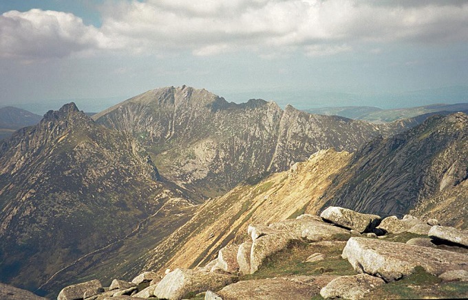
Granite Pluton, Isle of Arran
The North Arran Granite is a Paleocene igneous intrusion, about 10–12 km wide, and formed roughly 60 million years ago. It creates the rugged mountain peaks of the northern Isle of Arran, including prominent summits such as Goat Fell and Cìr Mhòr.
The landscape of northern Arran is dominated by a granite pluton. These plutons formed when magma intruded into the Earth’s crust during the early stages of the formation of the Atlantic Ocean. Later, the granite mass was cut by numerous igneous dykes and subsequently sculpted by glaciers, producing the dramatic and jagged mountain skyline visible today.
This granite pluton is composed of two main varieties—an outer zone of coarse-grained granite and an inner body of finer-grained granite. The structure indicates a large diapiric magma intrusion that rose upward through much older Dalradian Supergroup metasedimentary rocks, shaping the geological framework of Arran as described in studies of the island’s geological history.
In southern Arran, smaller but more varied intrusions of magma occurred around the same time as the formation of the northern granite. These intrusions created many striking coastal features. One of the most impressive is the Drumadoon Point, where the Doon cliff provides an outstanding example of an intrusive sill forming towering columns nearly 30 metres high. Detailed examination of this headland reveals changes in magma composition during successive intrusions. Similarly striking geological features can be observed in the sills and raised beaches of Holy Island and Pladda.
The Isle of Arran
The Isle of Arran provides exceptional opportunities to explore geological events in the region spanning the last 600 million years and serves as an outstanding example of volcanic igneous geology. The Isle consists not only of intrusive igneous rock but is also famous for its diverse landscapes, lying directly along the Highland Boundary Fault. Because of this unique position, it provides an ideal setting to observe the contrast between the ‘Highland’ and ‘Lowland’ geological regions for which Scotland is well known. This geological diversity is the main reason why the island attracts large numbers of geology students each year.
The Isle has an extensive geological history in such a short distance. During a walk of only about three kilometres, it is possible to encounter rock formations representing more than 100 million years of Earth’s history, ranging from the Devonian to the Permian periods. The sedimentary rocks along Arran’s eastern coast reveal Scotland’s movement across the Equator. Over time, the region shifted from desert conditions to tropical equatorial swamps and eventually back to desert environments. In effect, the landscape allows visitors to travel through time, witnessing the different climates and environments that existed over millions of years.
Also read- Loch Monar Polyphase Folding: Famous Superimposed Folding site
These rocks include conglomerates and sandstones that were deposited on land by braided river systems during seasonal flooding. Above these layers are alternating beds of limestone, coal, sandstone, and mudstone that formed in warm equatorial environments. Higher still are the red sandstones of the Permian desert, displaying structures such as dune bedding and breccia deposits typical of wadi systems. Together, these formations create an exceptionally varied and fascinating geological record.
Fossil Record
Arran also contains several remarkable fossil and trace fossil sites. Among these is a giant trail left by the ancient myriapod Arthropleura, one of the earliest known trackways made by a land-dwelling creature. David Attenborough famously filmed this remarkable fossil track in the television series Life on Earth. In the south of the island, sandstone layers from the Triassic period preserve footprints known as Chirotherium, left by early reptiles that resembled crocodiles.


