Jefferson Rock
Jefferson Rock is a well-known rock formation in Harpers Ferry National Historical Park, West Virginia, named after Thomas Jefferson, who famously praised its sweeping views of the confluence of the Potomac and Shenandoah rivers. Accessible by a short hike along the Appalachian Trail from town, the overlook offers panoramic views of the confluence of the rivers, the surrounding mountains, and the historic town below. Blending striking natural scenery with rich historical significance, it is a favorite destination for hikers and visitors alike.
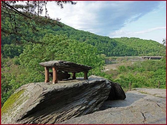
Harpers shale is composed of several large blocks and stacked atop one another. It overlooks the Shenandoah River just before it meets the Potomac River. On October 15, 1966, the site was listed on the National Register of Historic Places as a contributing feature of Harpers Ferry National Historical Park.
What is Jefferson Rock
Jefferson Rock is a natural shale rock formation, made up of stacked stone slabs, that sits high above the confluence of the Potomac and Shenandoah rivers.
Over time, the stacked shale slabs became unstable, so stone pillars were added beneath the upper slab in the mid-19th century to make the formation safe for visitors. Today, Jefferson Rock is both a geological feature and a historic viewpoint, offering sweeping vistas of rivers, mountains, and the historic town below.
From Lower Town, access the site by climbing the stone steps between the African American History Museum and the Civil War Museum on High Street. Continue past St. Peter’s Catholic Church to the next set of steps, then follow the path beyond the ruins of St. John Episcopal Church until you reach Jefferson Rock. Because of its steep and uneven terrain, the site is not accessible to visitors with physical limitations.
Also Read- Treasures of Raja Ampat Archipelago: The World’s Ultimate Marine Kingdom
Jefferson Rock Trail
Jefferson Rock Trail is a short yet rewarding historic footpath in Harpers Ferry National Historical Park, leading to one of the most iconic viewpoints in the region. Winding uphill from Lower Town, the trail follows a section of the Appalachian Trail and passes notable landmarks, including St. Peter’s Roman Catholic Church. Though steep in places, the climb is manageable and well worth the effort.
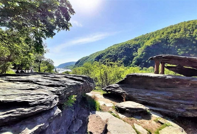
Jefferson Rock lies along the Appalachian Trail between the park’s Lower Town and Camp Hill areas, offering stunning views of the surrounding mountains, the confluence of the Potomac and Shenandoah rivers, and the dramatic water gap.
At the top, hikers are rewarded with sweeping views of the confluence of the Potomac and Shenandoah rivers, the dramatic water gap, and the surrounding Blue Ridge Mountains. The trail culminates at Jefferson Rock, making the walk a blend of natural beauty, geology, and American history. Ideal for history lovers and casual hikers alike, the Jefferson Rock Trail offers a powerful experience in a short distance.
Read- Geotourism And Modern Geotechniques
How to reach Jefferson Rock
To reach Jefferson Rock in Harpers Ferry, walk up High Street from Lower Town, find the stone steps past the Civil War Museum, climb them past St. Peter’s Church and the ruins of St. John’s Episcopal Church, and follow the signed, unpaved trail for about 5 minutes for a spectacular view of the river confluence. The hike is relatively short but can have steep, uneven sections, and while you can’t climb on the rock itself, the viewpoint is a short walk from the trail.


