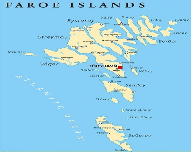
Faroe Islands
Located in the Northeast Atlantic, the Faroe Islands comprise 18 small islands and are Famous for cliffs, tall mountains, narrow fjords, and beautiful landscapes. The archipelago has the type of striking views typical of volcanic islands, like windswept mountains, crashing waves, and jagged coastlines. The island is officially part of the Kingdom of Denmark, but positioned between midway in Norway and Iceland.
In fact, the Faroe Islands lie on the Eurasian plate between Scotland, Norway, and Iceland. The islands are of volcanic origin and are made up of three layers of basalt. The Faroe Islands were formed in early Paleogene times.
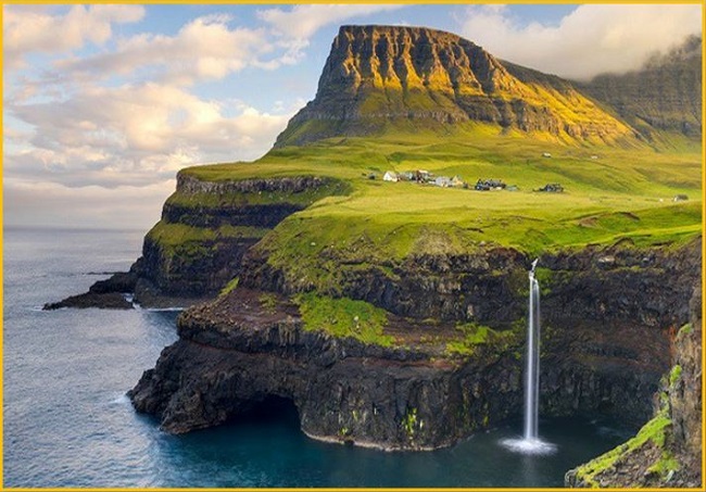
The island has a total area is about 1,400 square kilometers with a population of 50,000. Mulafossur is the most iconic landscape in the country; the narrow bay is cut into the cliffs, the waterfall hits the ocean, and behind it ascends a landscape that is worth seeing.
Faroe Islands Map
The Faroe Islands are a rugged archipelago of 18 islands situated in the North Atlantic, roughly halfway between Iceland and Norway, and bordered by the Norwegian Sea.
Faroe Islands Weather
The Faroe Islands are known as “The land of maybe” due to their highly volatile oceanic climate, which is typically mild, wet, and windy. It is common to experience “four seasons in one day” as rapid shifts in weather can turn fog and rain into sunshine within minutes.
Unpredictability: Weather conditions change rapidly and can vary significantly even over short distances, such as from one side of a mountain to the other. Fog is common, especially in late summer.
Mild Temperatures: Due to the influence of the North Atlantic Current, temperatures remain relatively mild year-round, typically averaging between 3°C in winter and 13°C in summer. Extreme cold or heat is rare.
Windy: The islands are exposed to strong and unpredictable winds. Wind chill can make the perceived temperature feel much colder than the actual reading. Average wind speeds range from 4 to 10 m/s, depending on location, with occasional severe storms, especially in winter.
Wet & Humid: Precipitation is frequent, with rain or showers occurring on roughly 270 days each year in some areas. While it rains often, the showers are usually short-lived. The central, higher-altitude areas receive more rainfall than the coastal areas.
Cloudy: The sky is often overcast or mostly cloudy throughout the year. Sunshine hours are low, particularly in winter (e.g., only around 7 hours of sunshine on average in December).
Also Read- Finland-A Nordic paradise and land of a thousand lakes
Faroe Islands Tourism
Tourism in the Faroe Islands centers on its dramatic landscape—featuring towering cliffs, fjords, and waterfalls—and its rich culture and history. While activities like hiking, bird watching, and boat trips are popular, visitors must be prepared for the highly unpredictable weather by bringing essential waterproof gear. Must-see sights include the Vestmanna Sea Cliffs and the picturesque villages of Saksun and Gásadalur, the latter being home to the famous Múlafossur Waterfall.
Hiking: Explore the dramatic landscapes on trails like the hike to Kallur Lighthouse or the hike to Trælanípa cliff, which offers views of the “floating lake” illusion. Boat tours: Sail through fjords, explore sea caves like the Concerto Grotto, or take a bird-watching tour to the Vestmanna Sea Cliffs.
Wildlife spotting: Look for puffins, particularly on the island of Mykines. Cultural experiences: Visit traditional villages like Saksun, explore the capital city of Tórshavn, and see historic buildings
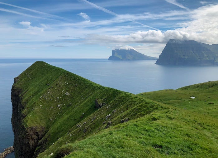
Beautiful Island Kalsoy and Eysturoy
The island of Kalsoy, marked by its steep peaks and rugged valleys, is one of the best places to hike on the archipelago. Take the 45-minute hike to the lighthouse on the northernmost tip, and you’re more likely to meet many species of red-legged black guillemot seabirds.
Eysturoy, the second-largest island of the Faroes, is home to 66 mountain peaks, including the tallest in the entire archipelago. Hiking here is so rugged and Adventurous.
Lake Sorvagsvatn
Lake Sorvagsvatn is the largest lake in the Faroe Islands. It seems that the lake is tilted towards the ocean, also looks like it’s perched hundreds of feet above the ocean. But this is actually an optical illusion. In actuality, the lake sits in a deep depression and is only about 30 m. above sea level. The cliff in front of the water gives the water body a “floating” appearance.
Read- Geotourism And Modern Geotechniques

Faroe architecture reflects the islands more beautifully. The homes are generally made from dark basalt and sport grass-turf rooftops. Faroe architects are very ambitious and growing in number every year. For centuries, the Faroese have defied the harsh nature and living conditions, but today are a nation in which the living standard is one of the highest in the world.
Positioned about midway between Norway and Iceland, A North Atlantic archipelago (the Faroe Islands) located 320 km north-northwest of the United Kingdom and only a couple of hours flight from the metropolitan centers in Northern Europe.
Flights to the Faroe Islands
Though the Faroe Islands are served by several daily flights from various European airports year-round, flight frequency peaks between May and August.
From Copenhagen (all days throughout the year)
From Keflavík (Monday and Friday all year round)
From Billund (several times a week)
Source-BBC, Atlas Obscura, Lonely Planet


