The Cascadia Subduction zone Hundreds
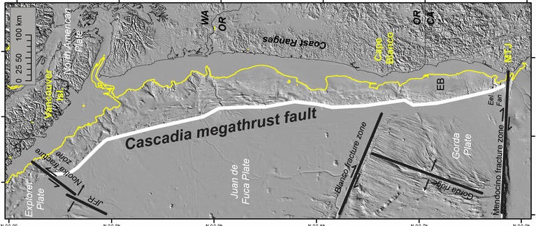
The Cascadia Subduction Zone is a geological feature located off the coast of the Pacific Northwest region of the United States, stretching from northern California to British Columbia, Canada. It is where the Juan de Fuca tectonic plate is slowly sliding under the North American plate, which can cause massive earthquakes and tsunamis.
Scientists have identified evidence of several massive earthquakes that have occurred in the Cascadia Subduction Zone over the past 10,000 years. Despite the potential danger, much of the Subduction Zone remains unexplored due to the difficulty of studying the region. It is located underwater, making it difficult to access and study. However, scientists have used a variety of techniques, including seismic imaging and deep-sea drilling, to study the region and understand the potential risks.
Cascadia Subduction zone and Earthquake
How far off the coast is the Cascadia Subduction zone
The distance of the subduction zone from the coast varies along its length, but on average, it is located approximately 80 to 160 kilometers from the shoreline. However, the width of the subduction zone, which is the distance between the Juan de Fuca plate and the North American plate, can be up to 97 kilometers in some areas. This means that the area of the ocean floor where the subduction is occurring is quite large and could potentially generate a massive earthquake and tsunami that could impact the coastal areas nearby.
Also read- Olympus Mons- A Super Volcano that can Swallow entire chain of Hawaiian Islands
Rock type and Minerals at the Cascadia subduction zone
The Cascadia Subduction Zone is primarily composed of oceanic crust from the Juan de Fuca plate and continental crust from the North American plate. While there are various minerals present within these crustal rocks, the primary rocks found in the subduction zone are Basalt, Gabbro, Serpentine, Amphibole and Quartz.
In addition to these minerals, the subduction zone can also contain deposits of economically valuable minerals such as gold, silver, copper, and zinc that are formed through hydrothermal activity associated with the subduction process.
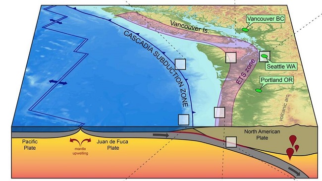
Cascade Volcanic Arc
The Cascade Volcanic Arc is a continental volcanic arc that consists of a series of Quaternary age stratovolcanoes that grew on top of pre-existing geologic materials that ranged from Miocene volcanics to glacial ice. The Cascade Volcanic arc is located approximately 100 km inland from the coast, and forms a north-to-south chain of peaks that average over 3,000 m in elevation. Some major peaks from south to north include-
- Lassen Peak and Mount Shasta (California)
- Crater Lake (Mazama), Three Sisters, Mount Jefferson, Mount Hood (Oregon)
- Mount Adams, Mount St. Helens, Mount Rainier, Glacier Peak, Mount Baker (Washington)
- Mount Garibaldi and Mount Meager massif (British Columbia)
The most active volcanoes in the chain include Mount St. Helens, Mount Baker, Lassen Peak, Mount Shasta, and Mount Hood.
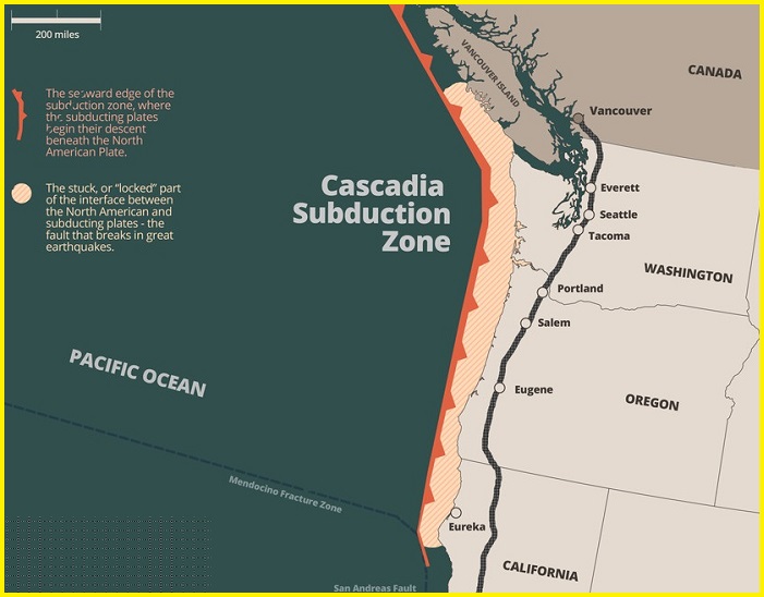
Where is the Cascadia subduction zone-The Cascadia Subduction Zone is located off the west coast of North America, stretching from Vancouver Island in British Columbia, Canada to northern California in the United States. The zone runs parallel to the Pacific Northwest coast, offshore from cities such as Vancouver, Seattle, Portland, and San Francisco. The Cascadia Subduction Zone is a geologically active region and has the potential to generate a massive earthquake.
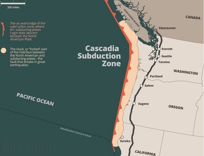
Map of the Cascadia Subduction zone- The map shows the approximate location of the subduction zone, as well as the major cities and towns that could be impacted by a large earthquake or tsunami.


