
Van Lake
Lake Van is the largest lake in Turkey, located in the Eastern Anatolia Region within the provinces of Van and Bitlis, in the Armenian Highlands. It is a saline soda lake fed by numerous small streams flowing down from the surrounding mountains. Classified as one of the world’s few large endorheic lakes (with no natural outlet) exceeding 3,000 km², it holds about 38% of Turkey’s total surface water, including rivers. The lake’s outlet was sealed by a prehistoric volcanic eruption, creating its current form. Situated at an elevation of 1,640 m, Lake Van in Turkey, rarely freezes despite its altitude and harsh winters, thanks to its high salinity—though its shallow northern areas may occasionally freeze.
Lake Hydrology
Lake Van stretches 119 km at its widest point, with an average depth of 171 m and a maximum recorded depth of 451 m. The lake’s surface lies at an elevation of 1,640 m above sea level, while its shoreline extends for about 430 km. Covering an area of 3,755 km², it holds an estimated 607 cubic km of water.
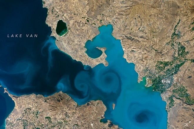
The western portion of Lake Van is the deepest, featuring a large basin over 400 m. deep, located northeast of Tatvan and south of Ahlat. The eastern arms of the lake are significantly shallower. The Van–Akdamar section shelves gradually, reaching a maximum depth of about 250 m on its northwest side, where it connects to the main body of the lake. The Erciş arm is the shallowest, with most areas less than 50 m. deep and a maximum depth of around 150 m.
Van Lake Salinity
The waters of Lake Van are highly alkaline, with a pH of 9.7–9.8, and contain large amounts of sodium carbonate and other salts. Some of these minerals are harvested in nearby salt evaporation ponds and used in detergents and cleaning products.
Geology
Lake Van Turkey is primarily a tectonic lake, formed more than 600,000 years ago through the gradual subsidence of a large crustal block caused by movements along several major faults in Eastern Anatolia. Its southern margin marks the boundary between the metamorphic rocks of the Bitlis Massif and volcanic strata dating from the Neogene and Quaternary periods. The lake’s deep western section forms an antidome basin within a tectonic depression, shaped by a combination of normal faulting, strike-slip movements, and thrusting.
Also read- Sarygamysh Lake: A Remote Oasis in Northern Turkmenistan
Located near the Karlıova triple junction, the region remains geologically active, with molten mantle fluids accumulating beneath the strata and driving ongoing change. On the northern shore rises Mount Süphan, a stratovolcano, while to the west lies Mount Nemrut, a dormant volcano with a broad crater near the lake’s edge. Hydrothermal activity is widespread throughout the surrounding area.
For much of its history, until the Pleistocene epoch, Lake Van drained southwestward into the Murat River, eventually joining the Euphrates. However, this outlet was repeatedly blocked by lava flows from Mount Nemrut extending westward into the Muş Plain, periodically raising the lake level. At times, erosion lowered the threshold, altering the outflow and reshaping the lake’s hydrology.
Islands
Lake Van contains four main islands: Adır, Akdamar, Çarpanak, and Kuş. Among them, Adır Island is the largest. Each island is notable for its historic Armenian religious sites: Lim Monastery on Adır Island, the famous Holy Cross Cathedral on Akdamar Island, Ktuts Monastery on Çarpanak Island, and a small monastery on Kuş Island.
Other Lakes
Several other large lakes lie close to Lake Van, including Lake Erçek (16 km away), Lake Turna (23 km), Lake Nemrut (12 km), Lake Nazik (16 km), Lake Batmış (10 km), Lake Aygır (5 km), and Lake Süphan (18 km). Of these, Lake Erçek is the largest, covering 106.2 km², making it the second largest lake in Van Province after Lake Van itself.
How To Reach Lake Van, Turkey
To reach the Lake, the most convenient option is to fly into Van Ferit Melen Airport, located just outside the city of Van, and then continue by taxi, local transfer, or bus to the lakeshore. Overland options are also available: long-distance buses connect Van and Tatvan with major cities such as Istanbul and Cappadocia, while the Van Express train offers a slower but scenic journey through the region. Once there, renting a car is highly recommended, as it allows you to explore the lake’s many towns, islands, and surrounding landscapes at your own pace.


