Dhola Sadiya Bridge
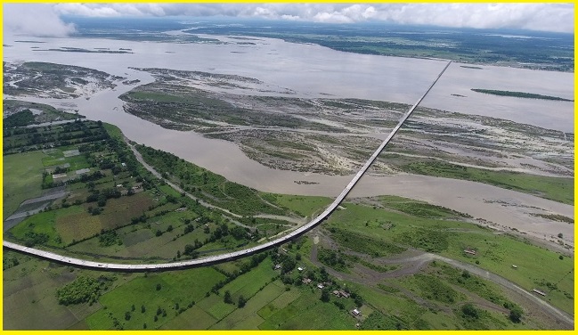
The Dhola-Sadiya Bridge, officially named the Bhupen Hazarika Bridge, is a beam bridge linking the villages of Dhola and Sadiya in Assam’s Tinsukia district. Stretching across the Lohit River, a major tributary of the Brahmaputra, it offers vital road access to Arunachal Pradesh, located just beyond Sadiya. This bridge establishes the first permanent road connection between northern Assam and eastern Arunachal Pradesh. Measuring 9.15 km, it stands as the second-longest water bridge in India.
Situated near the India–China border, the bridge plays a crucial strategic role by enabling the swift movement of the Indian Armed Forces into Arunachal Pradesh, a state claimed by China in the territorial dispute. Designed to withstand heavy military deployment, it can support 60-tonne Indian Army main battle tanks, making it a significant tactical asset.
Bhupen Hazarika Setu Map
India’s longest river bridge, Bhupen Hazarika Setu, which is 9.15 km long, connects the Dhola & Sadiya villages in Tinsukia. The bridge provides smooth and convenient access to several regions of Arunachal Pradesh, including Anjaw, Changlang, Dibang Valley, East Kameng, and East Siang, among others. Guwahati is approximately 544 km from the Bhupen Hazarika Setu via NH-715, making it a great route for a long road trip.

Given the proximity of the India-China border in Arunachal Pradesh, the bridge is an important asset in terms of transportation of essential goods and services for the Indian Army.
Also Read- Lake Van, Turkey: Geology, Islands, and Landscapes
Dhola Sadiya Bridge at Night
At night, the Dhola-Sadiya Bridge, also known as the Bhupen Hazarika Bridge, officially as the Dr. Bhupen Hazarika Setu, offers a spectacular sight as it glows under solar-powered lighting—a green initiative recently introduced by the Government of Assam. Stretching 9.15 kilometers across the Lohit River, it holds the title of India’s longest bridge and serves as a vital lifeline, seamlessly connecting Assam with Arunachal Pradesh and enhancing connectivity across the Northeast.
Dhola Sadiya Bridge to Roing Distance
The distance from the Bhupen Hazarika Setu to Roing is approximately 51.7 km by road


