Delaware Water Gap
The Delaware Water Gap is a picturesque water gap straddling the border of New Jersey and Pennsylvania, where the Delaware River carves its way through a striking ridge of the Appalachian Mountains.
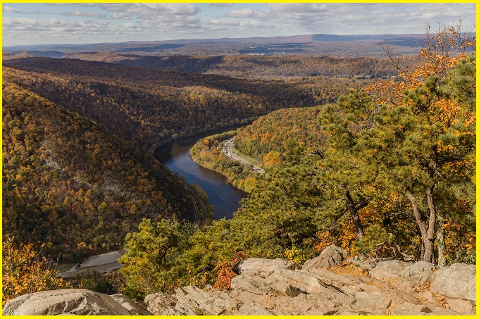
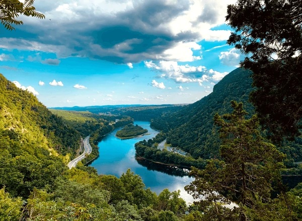
The Delaware Water Gap is one of America’s most striking examples of nature’s sculpting power. Millions of years ago, this region was a flat plain, but over time, erosion and gradual land uplift shaped the ridges we see today. While this geological process is common, what truly sets this gap apart is its exceptional beauty. The Delaware River winds through Kittatinny Mountain in a dramatic, tight “S” curve, creating a breathtaking landscape.
The natural wonder is a famous resort destination. Grand hotels welcomed visitors seeking fresh air and cool breezes, offering a refreshing escape from the sweltering summer heat of nearby cities. Some travelers even journeyed by train to Port Jervis and bicycled downhill to experience the beauty of the Water Gap firsthand.
The place is a well-known destination for outdoor pursuits such as canoeing, fishing, hiking, and rock climbing, primarily managed by the National Park Service.
Also read- Amazing Checkerboard Mesa: Nature’s Perfect Stone Grid Marvel
Delaware Water Gap
The Delaware Water Gap measures nearly 400 m across at river level and extends about 1.6 km between the summits of Mount Tammany and Mount Minsi. The elevation difference from the mountaintops down to the river exceeds 370 m, while the river itself flows at roughly 88 m above sea level.
Geology
The water gap geological feature formed when a river cuts through a mountain ridge. The Delaware Water Gap started taking shape around 500 million years ago, when quartz pebbles from surrounding mountains settled in a shallow sea. About 450 million years ago, the Martinsburg Shale on the eastern side of what later became Kittatinny Mountain was uplifted after a chain of volcanic islands collided with proto–North America. These islands were thrust over the continental plate, depositing rock layers that contributed to the formation of the Highlands and Kittatinny Valley.
Roughly 400 million years ago, another continental collision occurred. The immense heat and pressure partially melted the quartzite, allowing it to bend and deform. Over time, this rock layer was lifted and fractured. As these cracks expanded over thousands of years, the Delaware River slowly carved a path through the weakened quartzite. Without this fracturing, the river would not have been able to cut through the mountain and form the gap.
Also read- Geotourism And Modern Geotechniques
Over millions of years, natural forces such as rain, ice, snow, and wind gradually sculpted the landscape. During the Wisconsin Glaciation (around 21,000 BCE to 13,000 BCE), ice sheets covered the entire Kittatinny Ridge and extended as far as Belvidere. As the glaciers receded, the gap took on the form we see today.
Things to do in Delaware Water Gap
Sightseeing and Touring
More than 200 miles of roads wind through scenic valleys, across ridges, and past historic landmarks. Along these routes, visitors can enjoy waterfalls, relax at picnic spots, or explore trails and old roadways. The McDade Trail in Pennsylvania and paved routes in New Jersey offer excellent opportunities for scenic bicycling, although biking is not allowed on gated roads or restricted trails.
Camping
Tent and RV camping options are available at nearby private campgrounds. Primitive campsites are designated for through-hikers on the Appalachian Trail and for canoeists on extended river journeys. Campfires are not permitted along the Appalachian Trail.
Swimming
The Delaware River is considered one of the cleanest and most picturesque rivers in the eastern United States. Facilities such as bathhouses, picnic areas, parking, and lifeguard-supervised swimming zones are available at Smithfield and Milford beaches in Pennsylvania.
Boating
Approximately 40 miles of the Delaware River within the Delaware Water Gap recreation area attract enthusiasts of canoeing, tubing, and rafting. Access points every 8 to 10 miles make day trips convenient. Overnight trips are supported with designated riverside campsites. Licensed outfitters provide equipment rentals and transportation, including canoes, kayaks, tubes, and rafts. Despite its calm appearance, the river can be dangerous—always follow safety precaution.
Hiking
The park features nearly 100 miles of hiking trails, ranging from easy boardwalk paths to steep climbs of up to 1,000 feet, offering breathtaking views. The Appalachian Trail, stretching from Maine to Georgia, passes through the park for over 27 miles along Kittatinny Ridge, with backpacking permitted under regulations. Additional trails lead through hemlock ravines, past waterfalls, lakes, ponds, and along abandoned forest roads.
How to Reach Delaware Water Gap
The Delaware Water Gap National Recreation Area is located on the Pennsylvania/New Jersey border, primarily accessed via I-80 (east/west) or US 209 (north/south). Major airports include Newark (EWR) and Allentown (ABE), with bus services available from NYC to Delaware Water Gap and Milford via Martz-Trailways and Shortline.


