Madison Slide, Montana
The event dramatically reshaped the Madison River Canyon, creating a natural dam that still exists today. The landslide debris, containing schist, gneiss, and dolomite, rushed into the valley, traveling 400 feet up the opposite side of the canyon.
Quake Lake
Quake Lake, officially known as Earthquake Lake, formed after a major earthquake on August 17, 1959. Situated northwest of West Yellowstone, the lake stretches about six miles (10 km) long and reaches a maximum depth of 38 m. U.S. Route 287 runs alongside the lake, providing views of the earthquake and landslide impacts, and a visitor center is located nearby. Most of the lake lies within the Gallatin National Forest.
Madison Slide
The magnitude 7.3 Hebgen Lake earthquake struck at 11:37 p.m. local time on Monday, August 17, 1959, triggering the largest earthquake-induced landslide ever recorded in North America.
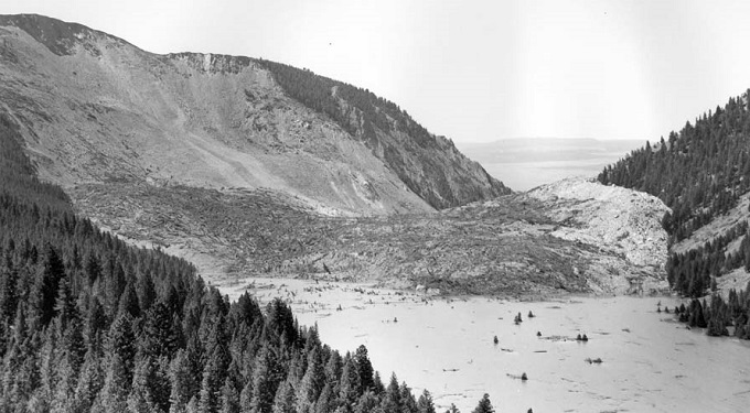
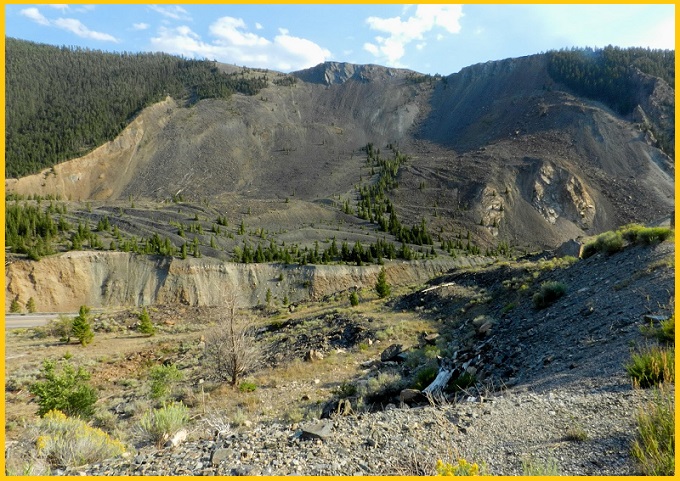
Centered near the mouth of Madison Canyon west of Hebgen Lake, the Madison Slide stretches about 1.6 km from head scarp to toe and spans roughly three-quarters of 1.2 km in width. A 400 m section of the south canyon wall collapsed northward into the Madison River Canyon, surging up to 131 m up the opposite wall in places. The debris formed a natural dam approximately 67 m high across the Madison River, rapidly creating Earthquake Lake. The slide mass is estimated at 28 to 33 million cubic meters and blankets around 130 acres.
Also read- Ancient Marvel: 3.5 Billion-Year-Old Stromatolites in Western Australia
Geology
A thick layer of Precambrian dolomite, dipping steeply northward at the base of the south canyon wall, acted as a supportive buttress for the heavily weathered and weaker schist and gneiss above. During the earthquake, intense shaking caused this dolomite support to fail, triggering the collapse of the entire canyon wall. The sliding mass largely preserved its original stratigraphic arrangement, with the dolomite forming a distinct tan-colored band at the front and the darker schist and gneiss trailing behind. Uprooted trees and topsoil from the north canyon wall settled atop the slide, indicating minimal mixing or disturbance during its movement.
How a Madison Landslide Occurs
According to eyewitness accounts, the Madison Slide occurred within seconds to as much as half a minute after the most intense shaking of the Hebgen Lake earthquake had subsided. Tragically, the slide’s eastern (upstream) edge engulfed the overflow camping area located just below the U.S. Forest Service’s Rock Creek Campground.
Also read- Geotourism And Modern Geotechniques
A surge of muddy water accompanied the slide along its upstream edge, sweeping trees, driftwood, and small rocks as high as 30 meters up the north canyon wall. This powerful wave—along with a hurricane-force air blast displaced by the moving debris—caused much of the destruction and many of the fatalities at the Rock Creek Campground.
By 6:30 a.m. the next morning, the rising waters of the newly formed Earthquake Lake had submerged all vehicles and trailers at the campground, reaching depths of at least 6 meters. Around 250 survivors gathered at Refuge Point, the highest ground between the Madison Slide and Hebgen Dam, but were effectively trapped as the earthquake had also destroyed the upstream road, cutting off escape from Madison River Canyon. The most critically injured were airlifted by Air Force helicopters around midday. By late afternoon, a hastily bulldozed road around landslides near Hebgen Lake enabled the remaining survivors to evacuate.
The U.S. Forest Service manages several geological sites in the Hebgen Lake area, including a visitor center atop the Madison Slide, along with interpretive displays marking the locations where survivors gathered on the night of the earthquake and the scarp created by the event.
How to Reach Madison Slide
To reach the Madison Slide, a massive 1959 earthquake landslide located along the Madison River in Montana, you should travel to the Earthquake Lake Visitor Center on US Highway 287.


