
Sugar Loaf Minnesota
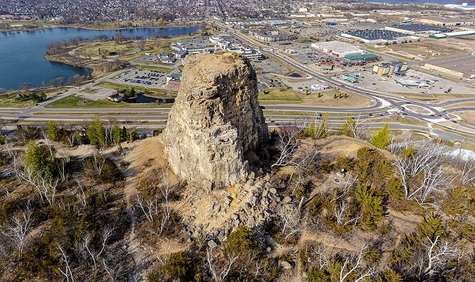
Sugar Loaf is a prominent 150 m bluff overlooking the city of Winona, Minnesota, and the Mississippi River. Its defining feature is a 26 m rock pinnacle, which was created by 19th-century quarrying and is sometimes what people refer to as “Sugar Loaf.” Recognized as one of Minnesota’s most famous landmarks for early travelers and tourists, Sugar Loaf was listed on the National Register of Historic Places in 1990 for its significance in entertainment and recreation.
History
The distinctive shape of Sugar Loaf is the result of both lore and industry. A Dakota legend claims the bluff was half of a large mountain, split and relocated by the Great Spirit following a dispute between two villages over a burial site. However, the bluff’s current form—a plateaued top crowned by a rock pinnacle—was created by European settlers who quarried the limestone for Winona’s construction from the mid-19th century until 1887. Today, the bluff is a popular destination where visitors can hike up and climb the pinnacle for views of the city.
Geology
Sugar Loaf Bluff in Winona, Minnesota, is composed of limestone bedrock that was quarried in the 19th century, which ultimately shaped its current form. The area’s broader geological history involves ancient basaltic lava flows from approximately 1.1 billion years ago, which created the bedrock foundation along the North Shore. The last major influence was the retreat of the glaciers from the last Ice Age, which eroded the softer surrounding deposits.
How Sugar Loaf formed
The distinctive pinnacle of Sugar Loaf was created when brothers John and Stephen O’Dea quarried the bluff’s limestone (Oneota dolomite) cap throughout the 1880s. This stone was heavily used to rebuild Winona’s infrastructure after the 1862 fire, particularly for replacing wooden sidewalks and constructing buildings. The use of this durable stone was so successful that an ordinance was passed in 1890 mandating stone-only sidewalks before the quarry closed in 1887.
A rare rockslide occurred in March 2004 when layers of limestone, loosened by long-term freeze-thaw cycles, peeled off the northwest face of the pinnacle. This event created a dark cascade of rock rubble across the snow and down the cliff, halting about 91 m from the closest dwelling.
Also Read- Why NIAGARA CAVE MINNESOTA is an Incredible destination
Sugar Loaf Trail
Sugar Loaf bluff now features newly updated hiking trails on its front side, providing silent (non-motorized) sport users with a unique vantage point over the city. Hikers and climbers (the park offers 35 bolted sport climbing routes from 5.3-5.11, all with stainless steel anchors) can begin the trail behind Edina Realty. Designated parking is available on Lake Boulevard and in the new paved lot south of Edina Realty; parking in the business lots (Edina Realty or Treasures Under Sugar Loaf Antiques) is prohibited.
Key Facts:
Sugar Loaf offers approximately 35 to 40 bolted sport climbing routes, ranging from 5.3 to 5.11 (YDS). The majority of these routes are concentrated in the 5.6 to 5.9 difficulty range. All routes are equipped with stainless steel glue-in anchors, making them suitable for both lowering and top-roping.
Read- Geotourism And Modern Geotechniques
How to Reach Sugar Loaf
To reach Sugar Loaf, visitors typically take two separate cable cars, requiring a short walk between the two stages. Alternatively, you may hike the first leg to the initial station at the base of Morro da Urca and then take the cable car for the final ascent. The best route depends on the exact destination on the mountain.


