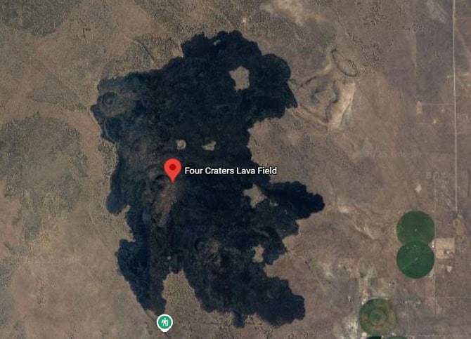
Four Craters Lava Field
The Four Craters Lava Field, along with Devils Garden and Squaw Ridge, a basaltic volcanic field southeast of the Newberry Caldera in Oregon, covers about 30 square kilometers and formed after the Mount Mazama eruption. Its flows originate from four Holocene cinder cones that are aligned along an N 30° W-trending fissure; these cones rise 75 to 120 meters and span a distance of about 3.5 kilometers. The age of the Four Craters lava field is uncertain, but it’s likely similar to that of Squaw Ridge and Devils Garden, suggesting it is probably around 10,000 to 20,000 years old.
Devils Garden- The name “Devils Garden” is a famous location near Four Craters lava fields. It is a 45-square-mile lava field designated as a Wilderness Study Area (WSA), which the USGS notes is accessible via jeep trails, foot, or helicopter.
Squaw Ridge- also known as the East Lava Field- is related to the Four Craters Lava Field; both are part of the young basaltic fields of the High Lava Plains. Squaw Ridge is characterized by a shield volcano and the Lava Mountain cinder cone at its center, with its lava flows extending up to 6 kilometers from the source.
Mount Mazama
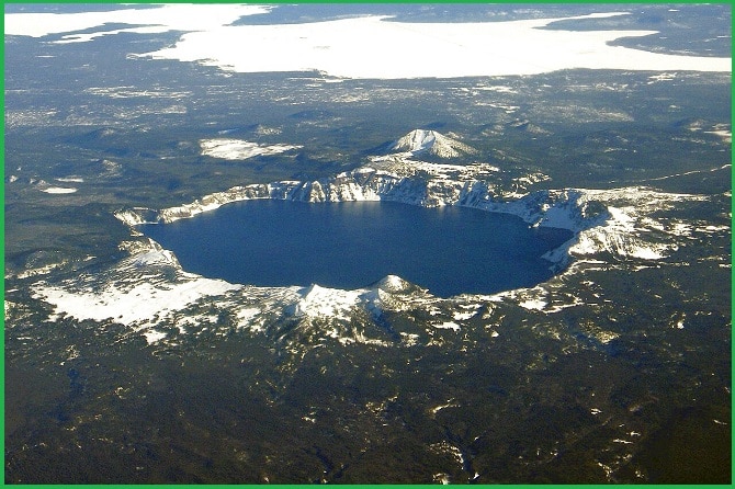
Mount Mazama, a complex volcano in the southern Cascade Range of Oregon, is located in Klamath County, about 97 km north of the California border. Its most notable feature is the Newberry Caldera formed by its collapse caused by the eruption emptying the underlying magma chamber, which now holds Crater Lake. Mount Mazama’s elevation dropped from approximately 3,700 m before its climactic eruption to 2,486 m afterward. Crater Lake is the deepest freshwater body in the U.S. and the second deepest in North America, reaching a depth of 592 m.
Also read- Crack-in-the-Ground: A 14,000 Years old Stunning Geological wonder
Mount Mazama and Crater Lake constitute part of the Mazama reach (or section) of the Oregon Cascades, extending 40 km from Timber Crater to the Big Bunchgrass shield volcano. This reach contains 175 Quaternary volcanic vents within a 25 to 30 km wide belt, resulting in a high density of shields and monogenetic volcanic centers. With an overall volume of 120 km, Mazama is the second largest but the most voluminous Quaternary volcanic edifice in Oregon after the Newberry Volcano. It is also the newest of the Quaternary calderas in the Cascade Volcanic Arc, a group that includes the Newberry and Medicine Lake calderas.
Crater Lake
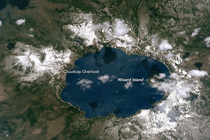
Crater Lake is a volcanic crater lake in south-central Oregon, famous as the main feature of Crater Lake National Park and for its striking deep blue color and water clarity. The lake partially fills a 655 m deep caldera created approximately 10000 years ago by the collapse of Mount Mazama. With a depth of 594 m, it is the deepest lake in the United States, ranking eleventh globally for maximum depth and fifth for mean depth. The lake has no inlets or outlets; water lost to evaporation is replaced by rain and snow. The lake also features two small islands: Wizard Island, a 128-hectare cinder cone near the western shore, and Phantom Ship, a natural rock pillar near the southern shore.
Crack-in-the-Ground
The Four Craters lava field is closely associated with Crack-in-the-Ground, located at the field’s southwest corner. The eruptions caused a slight sinking of the underlying older rock, forming a shallow, graben-like depression approximately 3 kilometers wide that extends southward into an ancient lake basin. Crack-in-the-Ground marks the western boundary of this small volcano-tectonic depression, presenting as a tension fracture nearly 9 meters deep and over 5 meters wide. The crack resulted from the Green Mountain lava flows draping over the edge of the upthrown side of a concealed fault zone, creating a hingeline.
Crater Lake National Park
Crater Lake National Park encompasses 650 square km, covering forest, alpine terrain, Crater Lake, and the majority of Mount Mazama. Dedicated in 1902 as a wilderness area and managed by the National Park Service, it welcomes about 500,000 visitors annually. Tourists can enjoy recreational activities such as hiking, biking, swimming, fishing, camping, and various tours. While the park is open year-round, certain roads and facilities are closed during the winter season.
Read- Geotourism And Modern Geotechniques
Accessibility
The area, roughly oval in shape, is bordered by a low-standard dirt road to the west and north, and by private land to the east and south. A low-standard dirt road also defines about 2 miles of the southeast boundary, and a 1.7-mile dead-end road forms part of the northern boundary as it extends into the area.
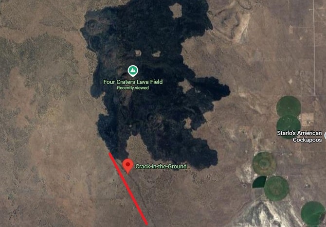
The area is split into two nearly equal parts: rugged lava flows and cinder cones, and sagebrush/grassland flats. Geologically, the area features the “Crack in the Ground,” a large tension fracture in the basalt, running approximately 3 km long, reaching 9 meters deep, and up to 5 meters wide; other tension fractures, volcanic spires, and pressure ridges also occur in the lava flow sections.


