New Red Sandstone
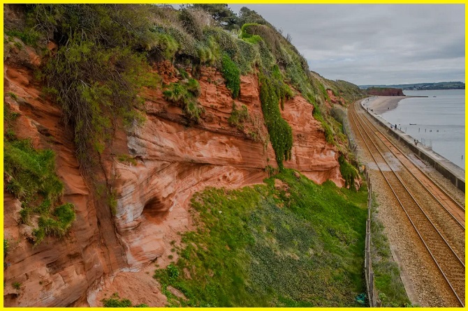
The Permian Red Sandstone Cliffs in Dawlish, Devon, are a geological site featuring colorful cliffs made of Permian-era New Red Sandstone. Formed from wind-blown sand in a desert environment approximately 250 million years ago, these outcrops are easily accessible via the South West Coast Path. They are a reminder of when Britain was located near the equator. The site is also critical for understanding ancient desert and river systems, as the upper part of the formation shows evidence of a river system reworking the original desert sands.
This red sandstone is a spectacular geological reminder of a time when Britain was located near the equator, a region once characterized by deserts. The colorful cliffs along the Dawlish Coast are composed of New Red Sandstone—aeolian (wind-blown) sand deposited in a continental interior during the Permian Period, approximately 250 million years ago. These outcrops are easily viewed from the train and accessible via public transport and the South West Coast Path.
How Cliff Forms
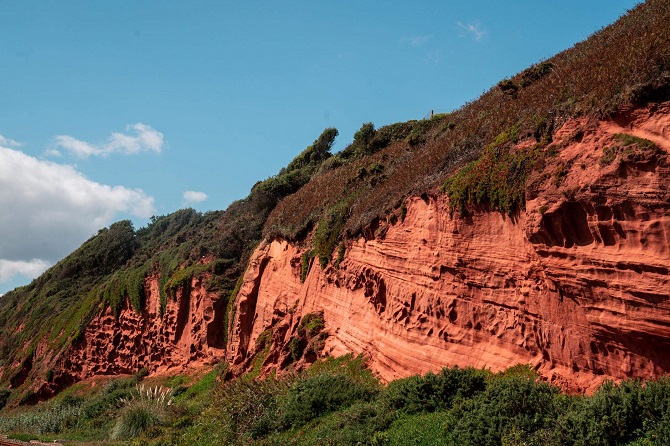
The Dawlish Cliffs offer a critical insight into ancient aeolian sedimentation. These cliffs, formed primarily from oxidized red desert sands laid down as dunes—many showing beautiful dune cross-bedding—also contain beds of angular pebbles deposited by repeated flash floods during wetter periods. Unusually, these Permian desert deposits may represent sediment accumulation over just a few tens or hundreds of years, rather than the thousands of years typically seen in similar cliff formations.
The Cliffs, Orientation, and Bross-Bedding
Walking north from Coryton’s Cove at the southern end of the Dawlish coast, you can examine the geological sequence. At the cove, you’ll find the Coryton Breccia (containing clasts like quartzite and pink feldspars) and the Teignmouth Breccia (with slates, cherts, and igneous rocks from the Devonian and Carboniferous periods). Both breccias were deposited in an alluvial fan. A major fault at Coryton’s Cove then juxtaposes these breccias with the overlying Dawlish Sandstone.
Also read- The Burren Ireland-A Journey Through the Limestone Wonderland
The sandstone cliffs north of the railway station are viewable from the sea wall, though the adjacent railway line prevents close-up examination. Access should be avoided during high tide or stormy weather due to dangerous wave exposure.
Geologically, the cliffs showcase large-scale cross-bedding (best seen near Black Bridge), indicating the ancient dunes migrated eastwards. They also contain clear evidence of flash flooding: stream beds filled with larger clasts were covered by subsequent deposits of wind-blown sand. These layers were originally horizontal but have been tilted with the rest of the formation.
At the turn toward Dawlish Warren, Langstone Rock, the type section for the formation, displays the Exe Breccia—coarse alluvial fan sediments. Stratigraphically, the change from the underlying wind-lain Dawlish Sandstone to the overlying water-lain Exe Breccia likely represents a Lower Permian climate change and an increase in rainfall. A natural arch is visible from the north side, offering a view toward the start of the Jurassic Coast on the west side of the Exe estuary.
Also read- Business leaders’ Success Story
How to Reach Red Sandstone Cliffs in Dawlish
You can reach the red sandstone cliffs near Dawlish by taking the train, bus, or car to the Dawlish Warren area, then walking along the coastal path or beach. The cliffs are accessible from the beach between Dawlish and Dawlish Warren, with Langstone Rock being a prominent feature.


