
Dalradian Marble
Dalradian Marble, folded rocks in western Ireland, is often known as a structural and metamorphic paradise. During the Grampian orogeny, amphibolite-facies schists, marbles, and amphibolites were intensely folded and metamorphosed, creating an extraordinary variety of folds at every scale.
The characteristic late Precambrian Dalradian rock types helped geologists in the 1960s unravel Connemara’s complex geology, revealing both older and younger major fold structures. The dedicated efforts of former Society President Bernard Leake resulted in detailed geological maps covering nearly all of Connemara, along with a comprehensive Memoir and numerous scientific papers. Recent studies indicate that Connemara’s deformation and metamorphism occurred within just a few million years during the Ordovician period, associated with a brief episode of volcanic arc activity.
Dalradian Sequence
The Dalradian, a sequence over 15 km thick composed of metasedimentary and metavolcanic rocks, extends across a wide zone of central Scotland. This region forms the Grampian Terrane, a segment of crust that originally accumulated along the Late Precambrian to Early Paleozoic margin of the ancient continent Laurentia, bordered by the long-vanished Iapetus Ocean. Today, the Grampian Terrane lies between two major crustal sutures—the Great Glen Fault to the north and the Highland Boundary Fault to the south—with Dalradian rocks resting upon the Laurentian basement.
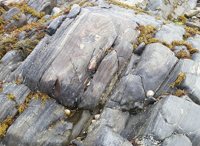
Cur Hill
Cur Hill, located in the northeast of Connemara, forms a striking ridge along the southern side of the Maam Valley. It exposes a section through a synclinorium, with marble present on both the northern and southern flanks as well as in parasitic folds along its length. The impressive folded marble seen here occurs on the southern side of Cur Hill, closely associated with pelitic schists that contain staurolite and sillimanite.
Also read- Knockan Crag-Unraveling Scotland’s Geological Mysteries
This marble is exceptionally pure, containing only minor quartz and variable traces of graphite—qualities that likely contribute to its beautifully developed, similar-style folds. In contrast, a nearby outcrop, rarely photographed, includes rusty-weathering siliceous layers and exhibits far more irregular folding.
The Maam Valley
The Maam Valley is a prominent north–south–oriented glacial valley in Connemara, County Galway. This particular site lies within the Failmore River Valley, spanning the townlands of Teernakill (West) and Cur. It can be reached via the Western Way trail leading to the Maméan Pass, which crosses the Maumturk Mountains and connects to the Inagh Valley. Maméan sits on the northern limb of the Connemara Antiform and is composed of east–west–striking Middle Dalradian marbles, metasedimentary rocks, and amphibolites.
Also Read- Business leaders Success story
Parasitic Fold
A parasitic fold is a smaller, short-wavelength fold that forms on the limbs or within the hinge zone of a larger, primary fold. These secondary folds are often asymmetrical, typically showing distinctive “S” or “Z” shapes on the limbs, with their vergence (direction of asymmetry) corresponding to that of the main structure. Parasitic folds are common in deformed sedimentary rocks composed of layers with contrasting strengths, and their formation is influenced by the thickness and mechanical properties of the rock layers—a process known as polyharmonic folding.
How to Reach Dalradian Marble
To visit specific Dalradian marble sites, follow directions for the individual outcrop, as “Dalradian marble” encompasses multiple locations. For instance, at Portsoy, Scotland, you can reach the marble outcrop by walking or driving up Cullen Street to the clifftop car park, then following the path west along the cliffs. In Ireland, the renowned Connemara marble—notably the folded beds at Cur Hill—can be accessed via the Maam Valley, County Galway, on the southern slope of the hill.


