Tessellated Pavement
A tessellated pavement is a striking, naturally occurring geological formation where a flat rock surface is fractured into polygonal blocks, resembling a tiled floor. This phenomenon forms when Earth’s movements initially crack the rock, and subsequent erosion from factors like salt crystallization and water deepens the joints. The renowned example at Eaglehawk Neck, Tasmania, showcases unique “pan” (depressed) and “loaf” (raised) features, making it a favorite photography and tourist destination, especially at low tide during sunrise.
Geology
Geologists define a tessellated pavement as a flat, exposed rock surface that joints have systematically broken into polygonal sections. The name comes from the way these fractured blocks mimic the orderly, tiled pattern of a mosaic or tessellation. Tessellated pavements can be classified into four types based on their formation: those resulting from jointing, cooling contraction (like in basalt), mud cracking followed by lithification, and sandstone pavements of uncertain origin.
Common Jointing
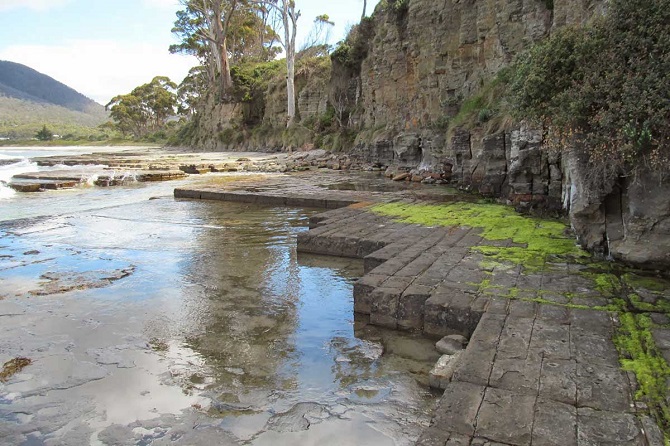
The most frequent type involves flat surfaces of sedimentary rock (like Sandstone ot Siltstone beds) systematically fractured into more or less regular rectangles or squares by perpendicular (orthogonal) joint systems. The resulting shapes—squares, rectangles, or occasionally triangles—depend on the orientation of these fracture sets. Weathering often erodes the bedrock along the joints unevenly, creating raised or recessed patterns on the surface. These are typically seen on wave-cut platforms along shorelines, where wave action exposes and cleans the jointed rock.
Cooling Contraction
The second type is characterized by a bedrock surface featuring very regular, polygonal joints, often hexagonal, which are the cross-sections of columnar jointing. This formation occurs when basaltic lava cools and contracts. A classic example of this structure is the Giant’s Causeway in Northern Ireland. Tessellated pavement is an extremely rare natural phenomenon, occurring in only a few locations globally where fractured rocks form striking, polygonal blocks that resemble man-made tiles.
Tessellated Pavement Tasmania
Tessellated Pavement, Tasmania, a short drive from Hobart, is a must-see destination. Named for the striking, tiled appearance of its waterside rocks, the geological phenomenon is a treat for nature enthusiasts and anyone who appreciates the unique aspects of the Tassie wilderness. The rocks are accessible after a short walk from the car park, and descending several sets of steps to get up close is highly recommended if you have the time.
Also read- The Untold Secret of ‘THE PINNACLES AUSTRALIA’
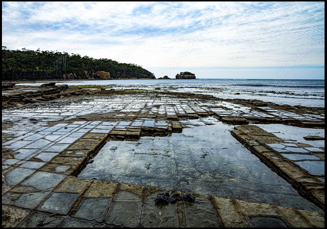
The Tessellated Pavement in Tasmania, Australia, is created by an orthogonal (right-angled) joint pattern in Siltstone. The photograph displays the “pan formation,” a shape that results from a unique geological process: millions of years ago, while the rock was still buried, hydrothermal solutions altered the rock directly along the joints, making it more resistant to erosion than the rock between the joints.
Conversely, the “loaf formation” develops when no such alteration occurred, or when the alteration lowered the rock’s resistance. In this case, the rock along the joints erodes faster than the rock distant from them, creating raised, loaf-like blocks.
How was the Tessellated Pavement Formed
Tessellated pavement formed around 300 million years ago when ancient siltstone fractured due to movements in the Earth’s crust, creating a network of joints. Over time, salt crystal growth and sea erosion accentuated these cracks, shaping them into raised “loaf” formations or recessed “pan” pools.
Tessellated Pavement Sunset
The Tessellated Pavement is best viewed and photographed at sunrise. This is because the eastern-facing beach is dramatically illuminated by the rising sun, creating light and reflective qualities that are far more striking than those captured at sunset.
Eaglehawk Neck Tessellated Pavement
The Neck is a dramatically narrow isthmus, less than 100 m wide at its slimmest point, connecting the Tasman and Forestier Peninsulas. Located roughly 20 km north of the Port Arthur Historic Site, this crucial piece of land was historically essential for security; it was the location of the Dog Line barricade, where fierce dogs were chained across the strip to prevent convict escapes. A sculpture now marks this dark past.
Nearby Attraction
The Neck is better known for its geological “rock stars.” Visitors flock here to see the geometrically perfect patterns of the Tessellated Pavement, the gaping Tasman’s Arch, the Blowhole, and the deep chasm known as Devil’s Kitchen. For outdoor enthusiasts eager to explore the region, popular activities include bushwalking in Tasman National Park, rock climbing, kayaking, diving, and surfing. Visitors can also enjoy an eco-cruise offering stunning views of the sea cliffs and opportunities to spot local wildlife such as seals, penguins, and dolphins.
Also read- Business Leaders’ Success Story
The Tasman Peninsula
The Tasman Peninsula, officially known as Turrakana / Tasman Peninsula, is situated in southeastern Tasmania, Australia, about 75 km southeast of Hobart via the Arthur Highway. It lies south and west of the Forestier Peninsula, connected to it by a narrow isthmus called Eaglehawk Neck. This, in turn, links to mainland Tasmania through another isthmus, East Bay Neck, near the town of Dunalley, roughly 60 km from Hobart. The peninsula is bordered by Norfolk Bay to the north, Frederick Henry Bay to the northwest, Storm Bay to the west and south, and the Tasman Sea to the east.
How to Reach Tessellated Pavement Tasmania
The easiest way to reach Tessellated Pavement Eaglehawk Neck on the Tasman Peninsula, fly to Hobart. From Hobart rent a car to reach the destination. It’s approximately 72-78 km and takes about 1 hour to 1 hour 15 minutes to drive one-way, depending on traffic.


