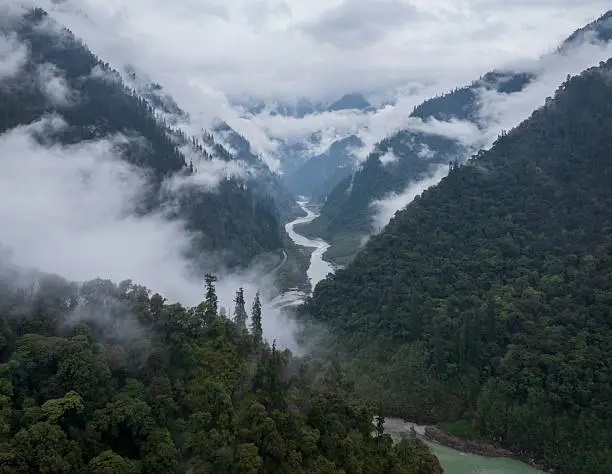
Yarlung Tsangpo Grand Canyon
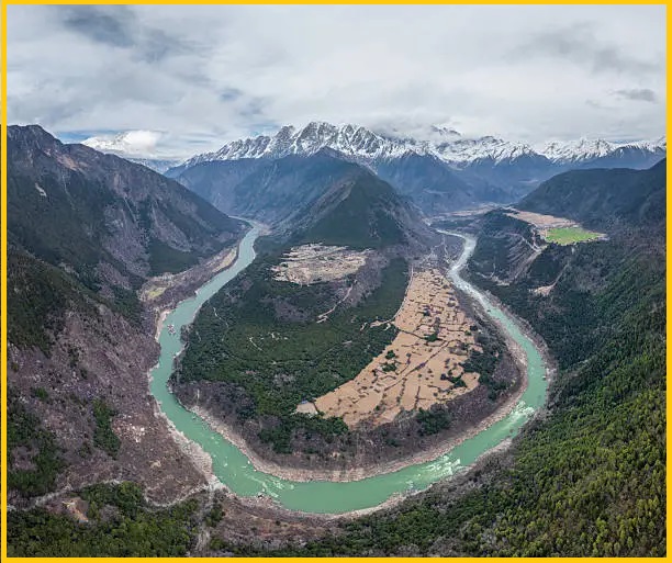
The Yarlung Tsangpo Grand Canyon, is a canyon carved by the Yarlung Tsangpo River in Tibet Autonomous Region, China. It is the deepest canyon in the world and, at 504.6 kilometres long, surpasses the Grand Canyon in the United States, making it one of the largest canyons globally. The Canyon is also known as Yarlung Zangbo Grand Canyon, Tsangpo Canyon, Brahmaputra Canyon, or Tsangpo Gorge.
The Yarlung Tsangpo—the Tibetan name for the upper course of the Brahmaputra—originates near Mount Kailash and flows eastward for approximately 1,700 kilometres, draining the northern Himalayas before entering the gorge just downstream of Pei, near the settlement of Zhibe. The canyon stretches about 240 kilometres as it curves around Mount Namcha Barwa 7,782 m, cutting through the eastern Himalayas. Its waters descend from roughly 2,900 metres near Pei to 1,500 metres at the end of the Upper Gorge, where the Po Tsangpo River joins. From there, the river flows through the Lower Gorge, reaching the Indian border at 660 metres, before entering Arunachal Pradesh and eventually becoming the Brahmaputra River.
Deepest Canyon on Earth
The Yarlung Tsangpo Grand Canyon, a massive arc-shaped trough valley, forms along the middle and lower stretches of the Yarlung Tsangpo River. The valley floor generally ranges from 100 to 200 meters in width, with its narrowest point located at the top of the canyon’s sharp bend. Here, between Namjagbarwa Mountain (7,782 m) to the south and Gala Peri Peak (7,294 m) to the north, the canyon narrows dramatically to just 70 meters.
As the canyon winds between the Namcha Barwa (Namjabarwa) and Gyala Peri mountains, it reaches an average depth of around 5,000 m near Namcha Barwa. Overall, the canyon has an average depth of about 2,268 m, with its deepest point plunging to 6,009 m. making it the deepest canyon on land.
Yarlung Tsangpo River
The Yarlung Tsangpo, also known as Yarlung Zangbo is a river flowing through the Tibet Autonomous Region of China and Arunachal Pradesh in India. It is the longest river in Tibet and the fifth-longest in China. The upper section of the river is also called Dangque Zangbu, meaning “Horse River.”
The river originates from the Angsi Glacier in western Tibet, southeast of Mount Kailash and Lake Manasarovar. It then flows through the South Tibet Valley and carves the Yarlung Tsangpo Grand Canyon before entering Arunachal Pradesh in India. Downstream in Arunachal Pradesh, the river widens and is called the Siang, and upon reaching Assam, it becomes the Brahmaputra.
Yarlung Tsangpo Grand Canyon National Nature Reserve
The Yarlung Tsangpo Grand Canyon National Nature Reserve is centered around the sharp bend of the Yarlung Tsangpo River in Pailong Township, Nyingchi County, Tibet. The reserve spans four counties in the Nyingchi region: Milin, Nyingchi, Bomi, and Motuo. Its northern boundary reaches Daduka Village (2,880 m above sea level), while the southern boundary extends to Bashika Village (115 m above sea level) in Medog (Motuo) County.
The Yarlung Tsangpo Grand Canyon National Nature Reserve primarily protects mountain forest ecosystems, rich biodiversity, the world’s largest canyon landscape, and the crucial water and air channels of the Qinghai-Tibet Plateau. The reserve contains the most complete vertical mountain ecosystem belt in the world, providing an excellent habitat for numerous wild species. Recognized as one of the planet’s most unique mountain biodiversity regions, the reserve has earned the titles “a natural museum of vegetation types” and “a gene bank of biological resources.”


