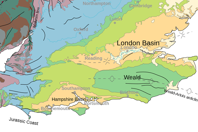
The Weald basin
The Weald Basin is a geological basin located in southern England, stretching across parts of Hampshire, Sussex, Kent, Surrey and Berkshire. It is bounded by the North Downs to the north, the South Downs to the south, and the chalk escarpments of the Greensand Ridge to the east and west.
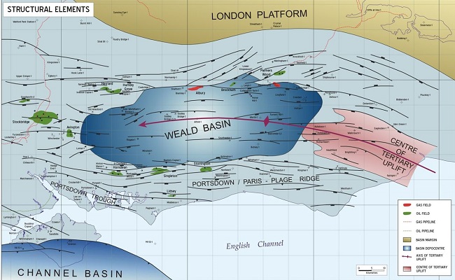
The Weald Basin is primarily known for its extensive reserves of hydrocarbons, particularly oil, which have been exploited since the early 20th century. The basin contains a thick sequence of sedimentary rocks, including sandstones, shales, and limestones, which were deposited during the Mesozoic Era, around 252 and 66 million years ago.
The oil and gas fields in the Weald Basin are relatively small and scattered, with most of the production coming from a few key sites, including the Wytch Farm oilfield in Dorset and the Singleton and Horndean oilfields in Sussex. In recent years, there has been controversy over the potential for hydraulic fracturing (fracking) to extract oil and gas from the Weald Basin, with concerns over the environmental impact and potential risks to local communities.
Geography
The Weald Basin is a major topographic feature of the area that is now southern England and northern France from the Triassic to the Late Cretaceous. Its uplift in the Late Cretaceous marked the formation of the Wealden Anticline. The rock strata contain hydrocarbon deposits which have yielded coal, oil and gas.
Basin Formation
The Weald Basin’s formation commenced during the Carboniferous, with the rocks which are today basement deposited within a low swamp providing minor coals deposit, how ever bore hole data failed to delineated potential coal deposit in the area. The Carboniferous coals may be overlain by early Triassic sediments. The sediments were uplifted and faulted within the Variscan Orogeny, with the land now occupied by the Basin being a low external fold belt to the main orogeny. The remnants of the mountain belt can be seen today in Devon and Cornwall in what is known as the Cornubian Massif.
The mountain belt collapsed soon after the orogeny, leading to the former northward thrusts to be reactivated as normal faults, and led to the formation of the Weald basin. The Weald basin gently subsided throughout the Jurassic, Cretaceous and Early Tertiary leading to a thick succession of sedimentary rocks being deposited. During the Early Jurassic a north and east shallowing mud-dominated shelf developed.
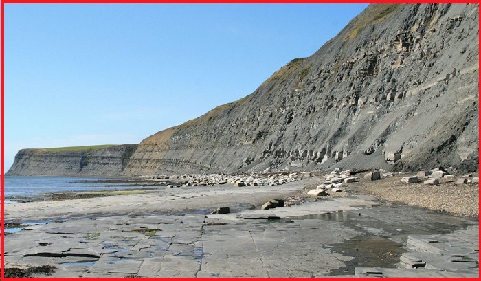
Jurassic shales of the Weald Basin
The Jurassic shales of the Weald Basin are a significant geological formation within the Weald Basin. The shales are part of a larger sequence of sedimentary rocks that were deposited during the Jurassic Period. The Jurassic shales in the Weald Basin are particularly noteworthy because they contain a significant amount of organic matter, which has been converted into hydrocarbons over millions of years of burial and compression. As a result, the shales are a potential source of oil and gas.
Also read- The Mysterious rock formations of Batanes Island Philippines
In recent years, there has been interest in exploring the potential of the Jurassic shales in the Weald Basin for unconventional oil and gas production using hydraulic fracturing (fracking). However, this has been a controversial issue, with concerns over the environmental impact of fracking and the potential risks to local communities.
In addition to their potential as a source of hydrocarbons, the Jurassic shales of the Weald Basin are also of scientific interest. They contain a diverse range of fossils, including the remains of dinosaurs, crocodiles, and other ancient reptiles, as well as numerous species of marine invertebrates. These fossils provide important insights into the evolution of life on Earth during the Jurassic Period.
Shale Oil
The Jurassic of the Weald Basin contains five organic-rich, marine shales- the Lower Jurassic Mid and Upper Lias, the Oxford Clay, Corallian Clay and Kimmeridge Clay. These have thicknesses of up to 90 meter, 60 meter, 152 meter, 80 meter, and 548 meter respectively. Where they have been buried to a sufficient depth to generate oil, all 5 have potential shale oil resources and are similar, but on a smaller scale, to the producing shale oil provinces of North America.
The British Geological Survey has estimate for the amount of shale oil and shale gas in the Weald Basin. The estimate is in the form of a range to reflect geological uncertainty. The range of shale oil in resource is 4.4 billion bbl or 591 million tonnes. No significant gas resource is recognised using the current geological model. This is mainly because the shale is not thought to have reached the geological maturity required to generate gas.


