Taklamakan Desert
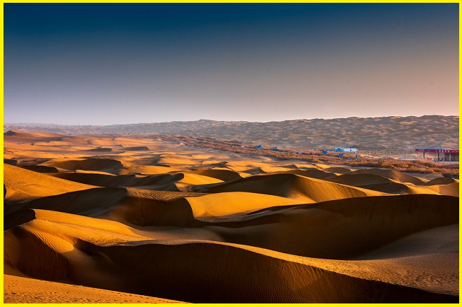
The Taklamakan Desert, often called the “Sea of Death”, is one of the largest sandy deserts in the world, covering about 337,000 km² in northwest China’s Xinjiang region. Situated in the Tarim Basin, towering mountain ranges surround it—the Kunlun to the south, the Pamirs to the west, and the Tian Shan to the north—while the Gobi Desert lies to its east. Famous for its vast expanses of shifting dunes, which make up nearly 85% of its surface, the Taklamakan is both a natural wonder and a historical landmark.
Geography
The Taklamakan Desert covers an area of about 337,000 km², making it slightly smaller than Germany. It lies within the Tarim Basin, which stretches roughly 1,000 kilometers in length and 400 kilometers in width. Historically, two branches of the Silk Road skirted its northern and southern edges, allowing travelers to avoid its inhospitable core. The Taklamakan is the world’s second-largest shifting sand desert, with around 85% of its surface composed of moving dunes, placing it 16th among the world’s largest deserts. Its dunes vary in height from about 18 meters to 91 meters, with steep slopes generally oriented away from prevailing winds. Scattered patches of alluvial clay provide the only breaks in this vast expanse of sand.
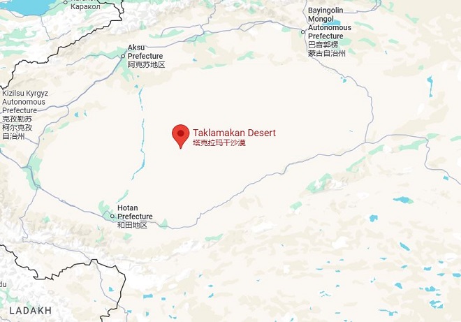
Taklamakan Desert Map
A map of the Taklamakan Desert in China’s Xinjiang Uyghur Autonomous Region depicts it as a vast expanse at the heart of the Tarim Basin, bordered by the Tien Shan Mountains to the north and the Kunlun Mountains to the south. Taklamakan Desert Maps often highlight the desert highway that cuts across the region, as well as the surrounding oasis towns and mountain ranges, including Kashgar, Khotan, and Turpan.
Taklamakan Desert Highway
The People’s Republic of China has built two major highways across the Taklamakan Desert. The Tarim Desert Highway connects Hotan on the southern edge with Luntai on the northern edge, while another route links Bayingol to Ruoqiang in the east. Because it is a shifting sand desert, the dunes are constantly reshaped by the wind. This movement causes encroachment on nearby grasslands and residential areas, leading to erosion and habitat loss.
The Taklamakan Desert is also traversed by the Golmud–Korla Railway. Notable named areas within the desert include Ha-la-ma, A-lang-ha, and Mai-k’o-tsa-k’o. In its western region lies the Mazartag mountain range.
Taklamakan Desert Facts
The Taklamakan Desert is extremely arid, with scarce water sources, making it dangerous to traverse. During the Silk Road era, merchant caravans relied on its flourishing oasis towns as vital stopovers for rest and supplies.
Also Read- Wonders of Austria: From Imperial Cities to Alpine Adventures
The main oasis towns, sustained by rainfall and runoff from surrounding mountains, included Kashgar, Miran, Niya, Yarkand, and Khotan (Hetian) in the south; Kuqa and Turpan in the north; and Loulan and Dunhuang in the east. Today, many of these sites—such as Miran and Gaochang—lie in ruins, with their remains scattered across sparsely populated areas of modern-day Xinjiang in the People’s Republic of China.
Archaeological discoveries from the sand-buried ruins of the Taklamakan reveal a blend of Tocharian, Hellenistic, Indian, and Buddhist influences. The desert’s riches and perils were vividly documented by explorers such as Aurel Stein, Sven Hedin, Albert von Le Coq, and Paul Pelliot. Among its most remarkable finds are well-preserved mummies, some of which date back as far as 4,000 years.
How to Reach the Taklamakan Desert
To visit the Taklamakan Desert in China, travelers typically fly into cities such as Hotan, Kashgar, or Aral, and then continue to the desert’s edge with the help of organized tours or private guides. Reaching these cities usually involves an international flight followed by a domestic connection. Because of the desert’s remote location and occasional security restrictions, special permits may also be required.


