PatalKot Valley- An Undiscovered hidden world, Take a GeoTourism around the wonderland !
Madhya Pradesh admires for its forest treasures and Patalkot is one of its best nature gifts with great geographical and scenic beauty situated in the hilly block of Tamia of Chindwara district. Patalkot valley is located at a distance of 78 km from Chhindwara and 20 km from Tamia in the North-East Direction. The Patalkot valley is spread over an area of 79 sq. km area and the ‘Doodhi’ river flows in the valley region.
Within the valley Patalkot there are 12 villages and 13 hamlets, which inhabit around 2000 people, according to the district website. The tribes inhabiting the valley have inculcated a strong reliance on forests and natural resources for their survival.

Patalkot’s name comes from the Sanskrit word “Patal” which means very deep, and ‘Kot’ means a place to live. According to people, Bhonsle Kings ruled this place in the 18th and 19th Centuries. after being defeated by the British Army Bhonsle king found this place suitable for hiding and went deep into the forest of Patalkot. Patalkot is of great importance because of its geographical and scenic beauty. there was a long tunnel connecting this place to Pachmarhi in the Hoshangabad district.
This valley had long been cut off from the rest of India and was discovered a few years back, Patalkot has been home to tribal culture and customs since its origin. It is said that Bharias tribes are living here for more than 600 years, The Patalkot forest is so well hidden that people on the outside did not even know it ever existed. the tribes living here were totally disconnected from the outside world because of the difficult terrain leading up to the valley, and the dense forests sprawling across.

Villagers usually trek ‘concrete steps to reach the top of the valley from interior hamlets, to cater to the needs of economic accessibility and outreach. Because of a difficult geographical location and scattered terrain, very few villages are easily connected via mainstream pathways.

There is a Myth that after worshiping ‘Lord Shiva’, Prince Meghnad(son of Ravana) had gone to PatalLok through this place. Traditionally, the site is believed to be the entrance to PatalLok (Hidden civilization beneath the earth). According to mythology, this is the place from where Lord Hanumana entered PatalLok to save Rama and Lakshmana from Ahiravana (King of PatalLok and Ravana’s brother) when Ahiravana kidnapped Rama and Lakshmana.
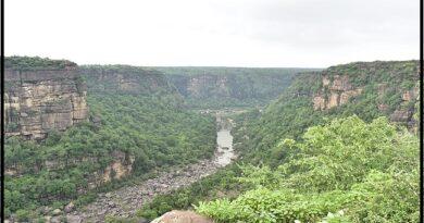
This horseshoe-shaped valley is surrounded by hills and there are several pathways to reach the villages located inside the valley. The lovely landscape is located at a depth of 1200-1500 feet in a valley. As soon as the clock strikes 4 pm, the village transforms into darkness, no sunlight reaches the depth of the mystical valley of Patalkot after a few hours past noon.

The best time to visit this beautiful valley is during monsoons, as it is sheltered, with clouds all around in the sky. Whether you wish to see tribes’ culture and inside valley’s scenic beauty best season is July to September.
The fair ‘Meghnath’ is celebrated on Chait Purnima (full moon night usually in March or April,) On this occasion, tribals make a wish and encircle a big pillar with their musical instruments Nagada, Shehnai, Tambura, Bansuri, Ghunghru, Khadtaal, Madar and Dhol.
The rocks are mostly from the Archaean era which is nearly 2500 million years and comprised of Granite gneiss, green schists, basic rocks, and quartz with Gondwana sediments including conglomerate sandstone, shales, and carbonaceous shales.
Geological History-
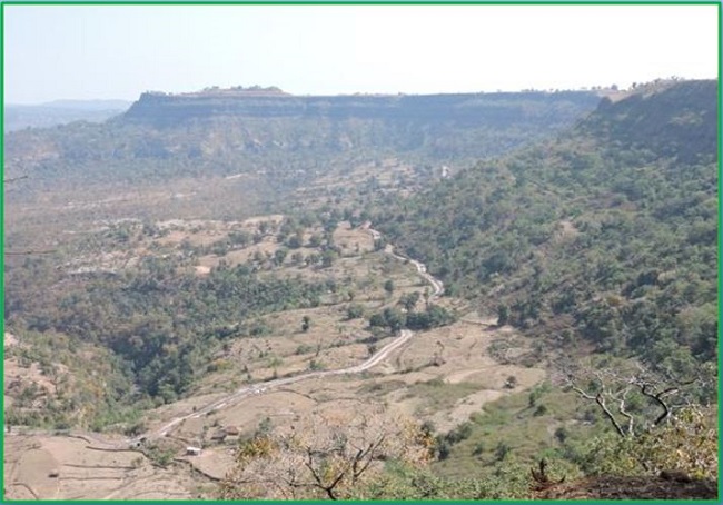
Patalkot is described often for its horseshoe shape, the deep gorge that segregates the valley, and the scenic beauty canopied with the mighty Satpura mountain ranges and forests. Patalkot is a lovely landscape located at a depth of 1200-1500 feet in a valley. The Valley formed actually decreases the rate of subsidence which is a deep depression in the hilly region.

The Gondwana basins of Peninsular India are intracratonic in nature surrounded by Precambrian terrains. They are disposed along ENE-WSW trending Narmada-Son-Damodar valley.

In the Patalkot region, clay facies of The Pachmarhi Formation comprises a recurring sequence of multistorey sandstone bodies that crop out largely in the southern and central parts as lofty hills and plateau. The Satpura Gondwana basin hosts a ~5 km thick siliciclastic succession that unconformably lies over the Precambrian basement.

In the Satpura Gondwana basin, periods of maximum subsidence are indicated by glaciomarine, fluviodeltaic, and fluvio-lacustrine regimes that prevailed during the Talchir, Barakar, and Bijori sedimentation respectively. Following the Bijori sedimentation, accumulation in the Satpura Gondwana basin took place under the alluvial regime indicating a decrease in the rate of subsidence. We can see the grain size, and scale of crossbedding in the upper part of each cycle of exposed strata.
multistory sandstone bodies which are parallel to depositing streams is a product of longitudinal bars and locally diagonal/transverse bars of low sinuosity braided streams. The generalized facies model

provides a basis for reconstructing the depositional environment of the Pachmarhi Formation. It is suggested that Pachmarhi sandstones are deposited in a braided river system under warm humid to subhumid climatic conditions.