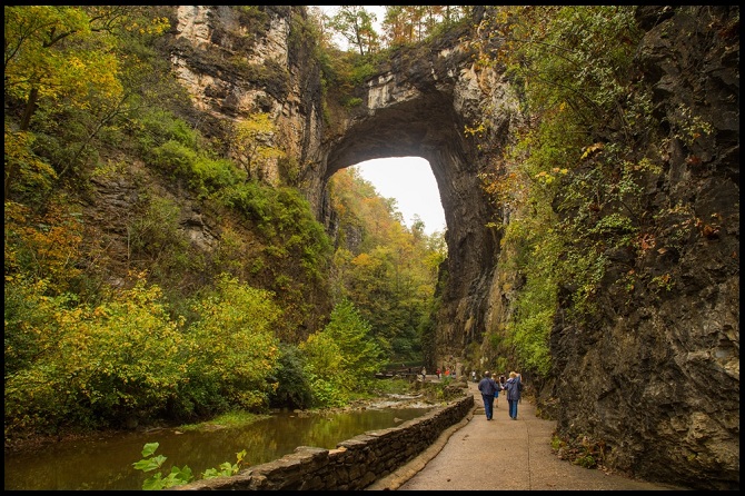
The Natural Bridge
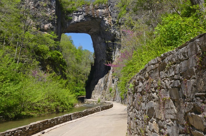
Natural Bridge is a prominent geological formation and National Historic Landmark in Rockbridge County, Virginia. This natural arch, standing 66 m high with a 27 m span, was carved out of mountainous limestone by Cedar Creek, a tributary of the James River. The bridge is believed to be the remnant of a cave roof through which the creek once flowed. Since 2016, it has been managed by the Commonwealth of Virginia as Natural Bridge State Park.
Geology
The Natural Bridge is composed of Ordovician limestones and dolomites, indicating the rock was deposited about 470 million years ago. The structure itself is made up of two distinct rock layers: the lower Chepultepec Formation forms the buttress, and the younger Beekmantown Formation lies conformably on top, forming the span and upper sections of the arch. Unusually, the rock strata in the bridge itself are horizontal, suggesting they form the bottom of a syncline (a fold where strata dip inward), contrasting sharply with the folded beds nearby.
The formation of the Natural Bridge is commonly attributed to three key elements: the southeast dip of the rock strata, the ability of water to slowly dissolve carbonates (limestone and dolomite), and the presence of numerous fractures in the rock. Edgar W. Spencer synthesized the most respected interpretations to produce the currently most widely accepted hypothesis explaining the bridge’s creation.
Lost River
According to Edgar W. Spencer, the Natural Bridge is the sole surviving fragment of the roof of an ancient underground river tunnel. This tunnel initially diverted water southward, capturing water from Poague Run (about two miles/3.2 km north) and significantly enlarging the nascent Cedar Creek drainage basin. Over immense stretches of time, weathering and erosion caused the majority of this underground river tunnel to collapse and disappear. The Natural Bridge is what remains of the roof structure that survived this collapse.
The increased water flow from the creek carved the present-day gorge, substantially increasing the vertical distance between the water’s surface and the ceiling of the former underground channel. The existence of the “Lost River”, located about 0.80 km (one-half mile) upstream from the Natural Bridge, provides concrete evidence supporting the underground river hypothesis. Water from the gorge sides continues to drain into Cedar Creek today.
Natural Bridge, Virginia hiking trails’ difficulty
The main trail at Natural Bridge, Virginia, is considered easy to moderate, as it involves descending and ascending about 120-134 stairs between the visitor center and the arch. Other trails in the park, such as the Blue Ridge Trail (3 miles), Buck Hill Trail (2 miles), and Skyline Trail (0.6 miles), vary in difficulty. Visitors should wear appropriate footwear due to elevation changes and the potential for rocky and slippery surfaces on some trails.
The park offers four main trails: The Natural Bridge Trail (approx. 1 mile round trip, Easy to Moderate) includes 120–134 stairs, which can make the ascent strenuous. Both the Blue Ridge Trail (3 miles) and the Buck Hill Trail (2 miles) are rated Moderate to Difficult. The Skyline Trail is the shortest at 0.6 miles, but it is still considered potentially strenuous due to steep and rocky sections.
Also read- Stunning Gosses Bluff: Jurassic–Cretaceous boundary Impact Crater
Natural Bridge State Park, Virginia
Natural Bridge State Park officially opened on September 24, 2016, and is now owned and managed by the Virginia Department of Conservation and Recreation. Visitors must purchase tickets to view the bridge from below, though the fees are roughly half of what was charged under previous ownership. The park features the trail along Cedar Creek beneath the bridge and the 30-foot (9.1 m) Lace Falls. Although U.S. Route 11 runs across the top of the bridge, protective fences block the view from the road. Notably, under state management, Foamhenge—a full-size Styrofoam replica of Stonehenge—was removed because the art installation did not align with the park’s mission and was relocated to Fairfax County.
Things to do around Natural Bridge, VA area
The area around Natural Bridge, VA, offers a variety of activities, including exploring natural sites like Natural Bridge State Park and the Caverns at Natural Bridge, visiting the Virginia Safari Park, and enjoying outdoor recreation like hiking and fishing. Other points of interest include the quirky Dinosaur Kingdom II, local breweries and orchards, as well as nearby historical sites.
Natural Bridge State Park: Visit the famous rock bridge, hike the trails along Cedar Creek, and enjoy excellent stargazing, as the park is a designated International Dark Sky Park. Caverns at Natural Bridge: Explore the deepest caverns on the East Coast and view their unique geological formations.
Virginia Safari Park: Experience a drive-through and walk-through safari to see a variety of exotic and native animals. Hiking: Explore numerous trails for all skill levels in the surrounding George Washington and Jefferson National Forests; a popular option is Devil’s Marbleyard. Fishing: Enjoy fishing in the area’s stocked streams, rivers, and lakes (a valid Virginia fishing license is mandatory for anyone over 16).
Best time to visit Natural Bridge in Virginia
The best time to visit Natural Bridge in Virginia is during spring (April) or fall (September/October), when the weather is mild and you can enjoy seasonal highlights such as fall foliage and spooky tours. Winter offers fewer crowds and unique experiences like ice skating, while summer brings warm temperatures and the popular evening illumination event held on the last Saturday of each month from April through October.
Walking tour times for the Natural Bridge of Virginia
The Natural Bridge of Virginia is open daily from 8:00 a.m. until dusk (weather permitting). Visitors should note there are no scheduled tour times; instead, they explore the one-mile, easy-rated trail at their own pace. While a quick visit to the bridge itself takes about 30 minutes (including the 137-step descent), the full one-mile loop will require more time depending on the individual’s pace.
Also read- Geotourism And Modern Geotechniques
How long does it take to walk the Natural Bridge trail?
Since “Natural Bridge” refers to a feature found in many parks, the time needed to walk its associated trail varies significantly—from a quick 15-minute walk (like in Death Valley) to 1.5 hours or more for complex hikes (like those in Yellowstone or California). Always check the specific trail’s length, elevation, and difficulty to accurately estimate your time.
Short and Easy: Quick hikes, such as the one in Death Valley, may only take about 15 minutes to reach the feature. Moderate: A 2.1-mile loop trail (like one in California) is estimated to take between 1 and 1.5 hours.
Longer/Complex: The 2.5-mile Natural Bridge trail in Yellowstone typically takes 1 to 2 hours, depending on hiking speed and time spent viewing the bridge. Park-Specific Examples: Parks like Natural Bridge State Park in Virginia offer multiple options; the main trail can take 1–2 hours to complete, with additional shorter trails available.
How To Reach Natural Bridge, Virginia
To reach Natural Bridge, Virginia, take Interstate 81 (I-81). Exit at 175 if traveling from the south, or 180A if traveling from the north. From either exit, follow US-11 signs for approximately two miles to the park entrance. The Natural Bridge Historic Hotel is also accessible from these I-81 exits.


