Factory Butte
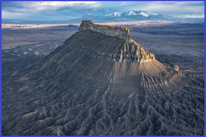
Factory Butte is a prominent summit, located at 1,921 m, in the Upper Blue Hills of northern Wayne County, Utah. Situated approximately 19 km northwest of Hanksville and 23 km east of the Capitol Reef National Park boundary, the butte was named by early settlers because its outline reminded them of a massive factory building, specifically the Provo Woolen Mill.
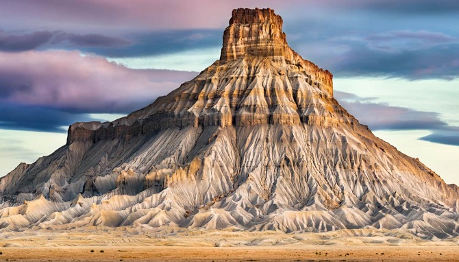
While Utah is famed for its wondrous national parks like Capitol Reef and Bryce Canyon, one such lesser-known marvel is Factory Butte, a cathedral-like sandstone hill that dramatically rises above the rugged Caineville badlands.
Factory Butte is part of the Upper Blue Hills, a small, flat-topped Mesa at 1,921 m. The summit appears deeply rooted, with crags, shoulders, and root-like combs that snake toward the hilltop, giving it the look of a massive, ancient rock stump. The surrounding barren landscape is equally otherworldly, creating the feeling of a known planet, a sensation often intensified by the near-total solitude you are likely to experience. The place is a colorful formation, and the scenery is striking even on an overcast day; it becomes truly surreal at sunset.
Also Read- Geotourism And Modern Geotechniques
How Factory Butte is Formed
The geology of Factory Butte is defined by two primary rock types. The approach and base, which constitute 70% of the monolith, are composed of Mancos mudstone (a clay/silt rock). This fine-grained material erodes into dramatic features like sharp rills, deep gullies, and classic badland formations. Capping the butte is Mesa Verde sandstone, which erodes into sheer, vertical cliffs. The butte itself is long and thin, with the long sides facing east and west. Erosion is most severe on the west and north faces. The steepness is intense on all sides, escalating from angles of 350 to 500 in the Mancos layer to completely vertical in the Mesa Verde sandstone. The butte rises approximately 610 m above its base, with the vertical section at the Mancos-Mesa Verde contact point measuring between 61–107 m tall.
Tourist Attraction
The Bureau of Land Management (BLM), which controls the Factory Butte area, describes it as a popular site for motor vehicle recreation. The butte is also celebrated for its unique flora; the Walla Walla Union-Bulletin noted it as a “Monolith that towers over the San Rafael Desert and harbors pockets of protected cacti,” attracting tourists who come to view and photograph blooming cacti and desert wildflowers. A separate peak, also named Factory Butte, is located about 24 km to the west-northwest in Emery County, Utah.
Also Read- The Great Escarpment’s Crown: Drakensberg Mountains, Africa
How to Reach Factory Butte
To reach Factory Butte, drive on Highway 24 about 12 miles west of Hanksville, Utah, and turn onto the dirt road (Factory Butte Road or Coal Mine Road). While the main road is often passable for most cars, a high-clearance or 4WD vehicle is recommended for driving closer to the badlands and behind the butte, especially after rain, as the volcanic ash can become muddy and impassable.


