
Borasu Pass
The Borasu Pass, also known as Bara-su, is a towering mountain pass situated on the border of Uttarakhand and Himachal Pradesh, historically sharing a border with Tibet. Once an ancient trade route connecting the Har ki Dun and Kinnaur valleys, the pass is now largely abandoned by locals and serves as a challenging escapade for trekkers and mountaineers.
Borasu Pass Trek Map
Map for the Borasu Pass trek (also spelled “Barasu Pass”) showing the approximate route, campsites, and key terrain features-
Map Details & Route Overview
The pass sits at about 5,450 m elevation. The traditional route starts from the Uttarakhand side (via Har Ki Dun valley / near Sankri) and ends in the Himachal Pradesh side (near Chitkul in the Baspa valley). You’ll see on the map: forests → alpine meadows → glacier/moraine field → the pass → descent into the other valley.
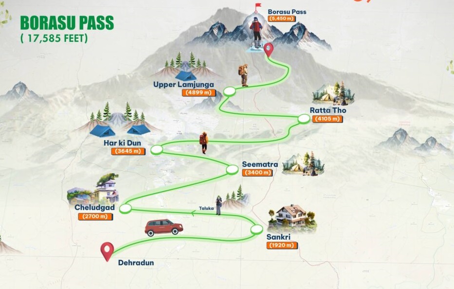
Map & route descriptions:
Taluka → Seema/Osla → Har Ki Dun. Danu Adventure+1
Har Ki Dun → Ratta-Tho (or Maninda Tal) → Upper Lamjunga/Borasu Pass base camp. Indiahikes+1
Summit pass → descend to Bonga Camp → Chitkul.
Borasu Pass Trek
The trek typically commences from Taluka, leading through the lush green Har ki Dun valley. Har ki Dun is a magnificent hanging valley nestled in the Garhwal Himalayas. It is characterized by its stunning backdrop of magnificent Himalayan peaks and dense forests, which are home to a vibrant array of colorful birds and diverse wildlife.
Also read- The Great Himalayan National Park: A Trekker’s Paradise
The journey begins by tracing the boisterous Har ki Dun Ganga river and culminates at the colossal Baspa River. Accommodations are available for trekkers, who can choose to relax at the Forest Rest House or set up camp near the Har ki Dun Ganga. An alternative camping spot is near Maninda Tal, a beautiful glacial lake located just a few kilometers from Har ki Dun.
The trail itself is demanding, traversing varied terrain that includes-
Glacier moraine
Steep, narrow ridges
Sheer vertical snow slopes
Boulder fields
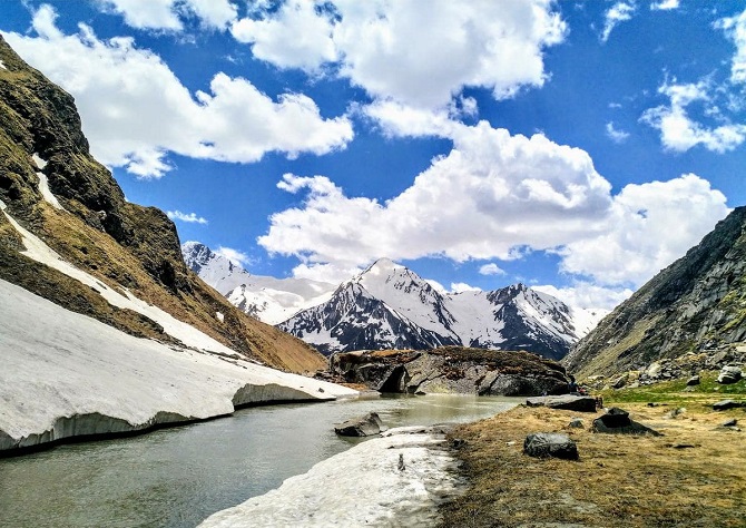
Overall, the Borasu Pass trek is a nerve-wracking experience. It offers a stunning blend of backwoods and vast meadows, featuring spurting rivers and widespread glaciers, all set against a backdrop of snow-capped peaks and massive boulders.
Borasu Pass Trek Distance
The Borasu Pass trek is a point-to-point trek that covers a distance of approximately 63 to 64 km on foot, starting from Sankri and ending at Chitkul. The journey can take around 8 days to complete, including travel to the base camp and from the endpoint. The total walking distance is approximately 63 to 64 km. The trail goes through the Har Ki Dun valley, a lush green area, before transitioning to a more challenging, rocky, and high-altitude landscape as you cross the pass into Himachal Pradesh.
Har Ki Dun Valley
Har ki Dun is often revered as the “Valley of the Gods” (where ‘Har’ signifies Lord Shiva and ‘Dun’ means Valley). Local folklore suggests this is a gathering place for fairies. The valley holds significant religious importance, being mentioned in ancient epics. It is believed to be the path the Pandavas took to ascend to Swarg (heaven) by climbing the Swargarohini peak.
The Temple of Osla
The village of Osla features a distinctive temple. While some colonies in the region once worshipped Duryodhana as a deity, the structure is now formally known as the Someshwar Temple. Referring to it as the Duryodhana Temple is generally considered offensive by the locals today, despite the historical belief that some people in the region once boasted of carrying Duryodhana’s lineage.
Also read- Business Leaders’ Success Story
Himalayan Vistas and Basecamp
The area also serves as a crucial base for expeditions approaching the magnificent Swargarohini peaks. From the valley, trekkers can enjoy spectacular views of several notable mountains, including the Bandarpoonch mountains, Ata Peak, Kalanag (or the Black peak), and Bonga Peak.


