
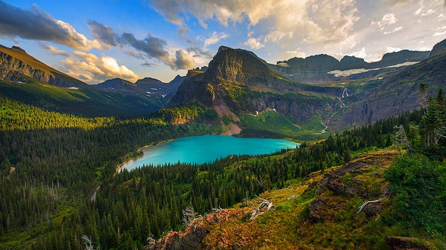
The crown of the continent
A guide to the places most respected and recommended by locals. Uncover the authentic character of a place called the Crown of the Continent. At the narrow waist of the Rocky Mountains, where Alberta, British Columbia, and Montana meet, sprawls one of the wildest, most diverse and intact ecosystems in the temperate zones of the world. Travel deep into the heart of the Rocky Mountains to celebrate an enduring monument to goodwill between Canada and the United States. Since 1932, Waterton-Glacier International Peace Park has been the jewel in a remarkable region known as the Crown of the Continent.
In the north, The crown of the continent the Rocky Mountain Front includes the 200 square miles area that is the Badger-Two Medicine portion of the Lewis and Clark National Forest. The Badger-Two Medicine is named for two crystalline rivers that begin in snowfields and rivulets along thirty miles of the Continental Divide, Badger Creek and the Two Medicine.
The crown of the continent
Directly adjacent to Glacier National Park, the Badger-Two Medicine roadless area is at the hub of a vast wilderness ecosystem as elk, grey wolves, bighorn sheep, moose, lynx, eagles, harlequin ducks, wolverines, and others that cross frequently between various jurisdictions and ownerships.
This area is directly adjacent to Glacier National Park and the Blackfeet Indian Reservation in Montana and is sacred ground to the Pikuni (Blackfeet) Nation. As an important spiritual retreat for the Blackfeet people, it is known as part of the “Backbone of the World.” These mountains include peaks with legendary Blackfeet names like Morning Star, Poia, Little Plume, Running Crane, Spotted Eagle, Kiyo, Scarface, Elk Calf, Bullshoe, Heart Butte, and Curly Bear.
The Badger-Two Medicine currently is at the epicenter of three oft-controversial issues: Oil and gas drilling, motorized recreation, and cultural claims of the Blackfeet Nation. The Blackfeet and the Lewis and Clark National Forest have proposed the designation of the area as a “Traditional Cultural District” under the National Historic Preservation Act. Consultations under this act have bolstered efforts by Blackfoot traditionalists and the Blackfeet Tribal Business Council to preclude proposed gas drilling and off-road motorized vehicles from the B2M.
Also read-Bora Bora Island-A Romantic Destination on Volcanic Terrain
Diverse montane landscapes, great scenery, camping, hiking, and trout fishing draw visitors to Beauvais Lake Provincial Park, a protected area that straddles the ecotone, or mixing zone, between native prairie grasslands and the Rocky Mountains.
The crown of the continent
Rare plants such as the white bog orchid, mountain lady slipper, and blue camas can be observed in spring and early summer bloom. Nestled in the foothills of southwest Alberta, almost 3,000 acres, this provincial park protects a unique landscape of fescue grassland, wetlands, and forests of aspen, poplar, Douglas fir, spruce, and pine. Beauvais Lake is home to loons, osprey, eagles, geese, mule deer, moose, elk, and black and grizzly bears to name a few species of wildlife that inhabit the montane landscape.
Also read- Spider Rock: The Sacred Pinnacle of Canyon de Chelly
As early as 1881, newcomers settled near Beauvais Lake; trails lead to these early homestead sites and to beaver ponds, wooded slopes, and lakeside walks.
Geotourism
Geotourism is tourism associated with geological attractions and destinations. Geotourism deals with the abiotic natural and built environments. Geotourism was first defined in England by Thomas Alfred Hose in 1995.
Geosites
A site is a location that has a particular geological or geomorphological significance. As well as its inherent geological characteristics it may also have cultural or heritage significance.
Geodiversity
Geodiversity is the variety of earth materials, forms and processes that constitute and shape the Earth, either the whole or a specific part of it.
Geotrails
According to the Geological Society of Australia, a geo trail “delivers tourism experiences through a journey linked by an area’s geology and landscape as the basis for providing visitor engagement, learning, and enjoyment”.
Geoparks
A Geopark is a unified area that advances the protection and use of geological heritage sustainably and promotes the economic well-being of the people who live there.
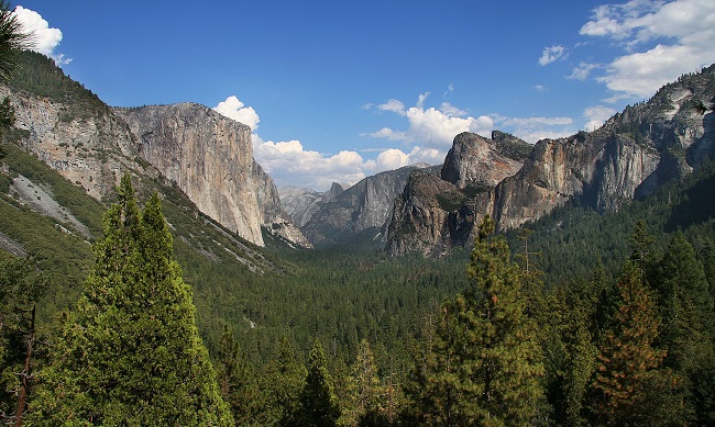
Sierra Nevada Mountains California
The Sierra Nevada is a mountain range in the Western United States, between the Central Valley of California and the Great Basin. The vast majority of the range lies in the state of California, although the Carson Range spur lies primarily in Nevada. The Sierra Nevada is part of the American Cordillera, an almost continuous chain of mountain ranges that forms the western “backbone” of the Americas.
The Sierra runs 640 km north-south and its width ranges from 80 km to 130 km across east–west. Notable features include General Sherman, the largest tree in the world by volume; Lake Tahoe, the largest alpine lake in North America; Mount Whitney at 4,421 m the highest point in the contiguous United States; and Yosemite Valley sculpted by glaciers from one-hundred-million-year-old granite, containing high waterfalls. The Sierra is home to three national parks, twenty wilderness areas, and two national monuments. These areas include Yosemite, Sequoia, and Kings Canyon National Parks; and Devils Postpile National Monument.
Eastern Sierra Nevada Mountains
The Eastern Sierra is a region in California comprising the eastern side of the Sierra Nevada, which includes the Mono and Inyo Counties. The main thoroughfare is U.S. Route 395, which passes through Bridgeport, Lee Vining, Bishop, Big Pine, Independence, Lone Pine, and Olancha, with Bishop being the largest city in the area. It is sparsely populated but well known for its scenery; major points of interest include Mono Lake, Bodie, Mammoth Lakes, Manzanar, and parts of Yosemite National Park and Death Valley National Park.
Geography
The Sierra Nevada lies primarily in central and eastern California, with the Carson Range, a small but historically important spur, extending into Nevada. West-to-east, the Sierra Nevada’s elevation increases gradually from 150 m in the Central Valley to more than 4,300 m atop the highest peaks of its crest 80–121 km to the east. The east slope forms the steep Sierra Escarpment. Unlike its surroundings, the range receives a substantial amount of snowfall and precipitation due to orographic lift.
The earliest rocks in the Sierra Nevada are metamorphic roof pendants of the Paleozoic age, the oldest being metasedimentary rocks from the Cambrian in the Mount Morrison region. These dark-coloured hornfels, slates, marbles, and schists are found in the western foothills (notably around Coarsegold, west of the Tehachapi Pass) and east of the Sierra Crest. The earliest granite of the Sierra started to form in the Triassic period. This granite is mostly found east of the crest and north of 37.2°N In the Triassic and into the Jurassic, an island arc collided with the west coast of North America and raised a chain of volcanoes, in an event called the Nevadan orogeny. Nearly all subaerial Sierran Arc volcanoes have since disappeared; their remains were redeposited during the Great Valley Sequence and the subsequent Cenozoic filling of the Great Valley, which is the source of much of the sedimentary rock in California.
Geotourist
With tours available in over 40 languages and route mapping from your location, Geotourist gives you the confidence to explore and the freedom to discover new places. Geotourist is your personal tour guide for the world’s top travel attractions, landmarks, and beyond. Based on your exact location access this app is working.
Build your journeys and inspire others to follow in your footsteps. Your audio will trigger as they walk along your path, in an immersive experience like never before. Immerse yourself in a world that comes alive as you roam, telling you their stories and connecting you with their communities. As a Geotourist one can Enjoy discounts from local businesses, book tickets to local events, along the routes – and avoid tourist traps. With tours available in over 40 languages and route mapping from your location, Geotourist gives you the confidence to explore and the freedom to discover stories all over the world.
Tourist app
Incredible India Tourist App
Incredible India App is an innovative project of the Ministry of Tourism to assist international and domestic tourists to showcase India as a holistic destination, revolving around major experiences such as spirituality, heritage, adventure, culture, yoga, wellness, and more.
The mobile app has been designed keeping in mind the preferences of the modern traveler. The app follows the trends and technologies of international standards and has been equipped with features to assist travelers in each phase of their journey to India.
5 Best Tourist Apps
Airbnb is an online marketplace that connects people who want to rent their homes with people looking for accommodation in that place. It is in more than 81,000 cities and 191 countries worldwide. One of the best travel apps for the travel and tourism industry.
Every outdoor explorer needs AllTrails on their phone. The application catalogs more than 75,000 trails in the United States and Canada, with useful filters to search for trails by skill level, accessibility, or friendship with dogs.


