Hike in Chile
Hiking in Chile offers an incredible variety of environments and climates, shaped by the country’s unique ribbon-like geography—stretching 4,300 kilometers in length but averaging only 175 kilometers in width. From the arid Atacama Desert in the north to the Mediterranean climate of the central region and the glaciers, fjords, and lakes of Patagonia in the south, the diversity is striking. The longest route is the informal 3,000 km Greater Patagonian Trail, developed through a non-governmental initiative.
The Sendero de Chile (“Chilean Trail”) project was launched in 2000 by the Chilean government to mark the country’s 2010 bicentenary of independence from Spain. Its goal was to connect Chile’s most breathtaking landscapes and cultural regions—ranging from the volcanic altiplano with its salt flats to the southernmost tip of the continent—through a vast national trail network. The plan envisioned around 8,500 km of signposted paths stretching the length of the country.
The trail was designed to be divided into nine hiking zones:
-
Iquique and Tarapacá
-
Calama
-
Atacama Coast
-
Central Andes
-
Alto Bío Bío
-
Andean Araucanía
-
Valdivian Forest
-
Patagonia Aysén
-
Última Esperanza
However, despite its ambition, the project faced major setbacks and a continuous long-distance trail was never completed. Today, the Sendero de Chile Foundation has shifted its focus toward environmental education and conservation.
Famous Hike in Chile
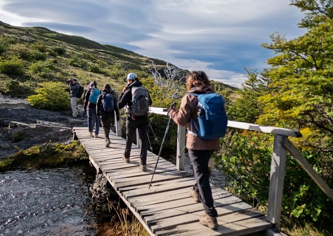
The W Trek in Torres del Paine National Park is Chile’s most iconic and popular hike, spanning 73 km over 4–5 days. This world-renowned route leads hikers through breathtaking Patagonian landscapes of granite spires, turquoise lakes, and massive glaciers. Shaped like the letter “W,” the trail passes three stunning valleys, featuring highlights such as the Base Torres, the French Valley, and the Grey Glacier. Along the way, trekkers can choose from a range of accommodations—from rustic campsites to comfortable mountain lodges (refugios)—making it accessible to different hiking styles.
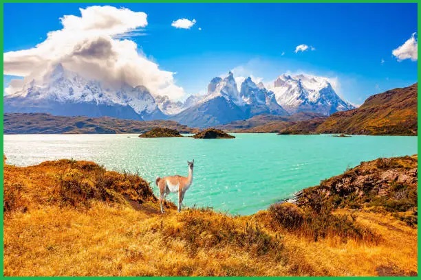
Torres del Paine National Park
Torres del Paine National Park is one of Chile’s most iconic natural reserves, renowned for its dramatic landscapes of mountains, glaciers, lakes, and rivers in southern Patagonia. At its heart lies the Cordillera del Paine, a striking mountain range situated between the Magellanic subpolar forests and the Patagonian steppes. The park is located about 112 km north of Puerto Natales and 312 km north of Punta Arenas, bordering Bernardo O’Higgins National Park to the west and Argentina’s Los Glaciares National Park to the north. The word Paine means “blue” in the indigenous Tehuelche (Aonikenk) language and is pronounced PIE-neh. The park was officially established in 1959.
Today, Torres del Paine is both one of the largest and most visited national parks in the country, attracting around 252,000 visitors annually—54% of whom are international travelers. It is also recognized as a UNESCO World Biosphere Reserve, highlighting its global ecological importance and the unique biodiversity of the Valdivian rainforest.
Geology
Much of the geology of the Paine Massif consists of Cretaceous sedimentary rocks that were later intruded by a Miocene-aged laccolith. Over millions of years, orogenic forces and erosion shaped the massif’s dramatic topography, while more recent glacial activity carved many of its striking features. A clear example is the Cuernos del Paine, where exposed bands of pale granite sharply contrast with the darker upper layers—remnants of eroded sedimentary rock. In contrast, at Las Torres, the overlying sedimentary layers have been completely worn away, leaving only the resistant granite spires that define the park today.
Also Read- The Amazing rock Formation-Marble caves, Patagonia in Chile
Other Notable Hike
Torres del Paine Full Circuit
Gazing at the towering, spire-like peaks of Patagonia’s Cordillera del Paine, you might think they belong in a scene from The Lord of the Rings. But these dramatic rock formations are very real—and even more awe-inspiring in person. Designed for adventurous yet accessible exploration, this journey takes you beyond the crowds into some of the park’s more remote and lesser-visited corners, where the landscapes defy imagination. With expert mountain guides leading the way, you can focus on spotting soaring condors and soaking in the scenery, rather than worrying about navigation.
Cerro Castillo Circuit
The Cerro Castillo Trek is the best hike in Patagonia, located in Chile’s remote Aysén Region—the country’s third largest but least populated—is a stunning trail such as the Torres del Paine or Argentina’s Fitz Roy trek in Los Glaciares National Park. For those seeking Patagonia’s wild beauty with a quieter, off-the-beaten-path experience, Cerro Castillo is a perfect choice.
Dientes de Navarino
The Los Dientes de Navarino Circuit—often called the southernmost trek on Earth—has earned international recognition for its remote lakes, jagged peaks, and solitude in the untouched wilds of Southern Patagonia. For those drawn to the planet’s most off-the-beaten-path trails, this trek deserves a top spot on your bucket list.
Covering 37 kilometers over 5 days, the route delivers a raw Patagonian experience. Expect shifting conditions—sun and warmth one moment, wind, snow, and cold the next. While the daily distances rarely exceed 10 kilometers, the rugged terrain and dramatic landscapes make every step demanding, rewarding, and unforgettable.
Selva Valdiviana
Chile’s Valdivian temperate rainforest, or Selva Valdiviana, stretches across the Andes between the central Mediterranean zone and the southern Magellanic subpolar forests of Patagonia, primarily within the Los Lagos and Los Ríos regions. This lush area is dotted with scenic lakes and volcanoes, including Llanquihue Lake, Osorno Volcano, Todos los Santos Lake, and Calbuco Volcano, making it a hotspot for nature lovers and outdoor adventures.
Atacama Coast
This zone encompasses the coastal area of Chile’s Atacama Region, where the arid Atacama Desert meets the Pacific Ocean. A highlight of the region is the Desierto Florido (“Flowering Desert”), which, after occasional above-average rainfall in July and August, can see up to 200 species of desert plants bloom between September and November.
Best time to hike in Chile
The ideal time to hike in Chile varies by region, but generally, late spring (October–November) and early fall (March–May) provide a balance of mild weather and smaller crowds, particularly in Patagonia and the Andes. The peak summer months (December–February) offer warmer temperatures and longer daylight, though trails in Patagonia can be busy and windy. In the Atacama Desert, hiking is possible year-round, but the shoulder seasons are preferable to avoid the extreme nighttime cold of winter.


