Ladakh Range: A Himalayan Paradise of Peaks and Passes
The Ladakh Range
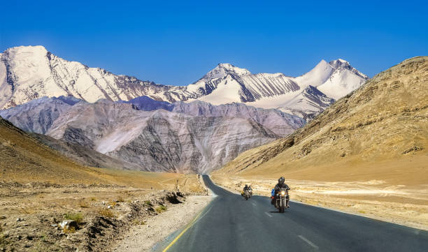
The Ladakh Range is a mountain range located in central Ladakh, India, with its northern extension reaching into Baltistan, Pakistan. It lies between the Indus and Shyok river valleys, stretching over 370 km. Leh, the capital of Ladakh, is situated at the foothills of the Ladakh Range in the Indus River valley.
The Ladakh Range is considered a southern extension of the Karakoram Range, stretching 370 km. from the confluence of the Indus and Shyok rivers in Baltistan to the Tibetan border of Ladakh in the southeast. In Tibet, the southern part of the Ladakh Range is referred to as the Kailash Range.
This mountain range forms the northeastern bank of the Indus River and the western bank of the Shyok River. With an average elevation of around 6,000 meters, the Ladakh Range does not feature any major peaks, though some of its summits are below 4,800 meters. Key mountain passes in the region include Chorbat (5,090 meters), Digar La (5,400 meters), Khardung La (5,602 meters), Chang La (5,599 meters), and Tsaka La (4,724 m.)
Geography
Ladakh is the highest plateau in India, with much of the region situated over 3,000 meters above sea level. It stretches from the Himalayan to the Kunlun Ranges and encompasses the upper Indus River valley. Historically, the region of Ladakh encompassed the Baltistan valleys (now mainly in Pakistani-administered Kashmir), the entire upper Indus Valley, the remote districts of Zanskar, Lahaul, and Spiti to the south, much of Ngari (including the Rudok region and Guge in the east), Aksai Chin in the northeast, and the Nubra Valley to the north, accessible via Khardung La in the Ladakh Range.
Also Read- Patan’s Stepwells and Temples: A Heritage Tour to Gujarat
Today, Ladakh borders Tibet to the east, the Lahaul and Spiti regions to the south, the Vale of Kashmir, Jammu, and the Baltiyul regions to the west, and the southwestern corner of Xinjiang, China, across the Karakoram Pass in the far north. The historically unclear boundary between Ladakh and the Tibetan Plateau begins in the north, in a complex network of ridges east of Rudok, including Aling Kangri and Mavang Kangri, and extends southeastward toward northwestern Nepal.

Leh is the largest town in Ladakh, followed by Kargil, with each serving as the headquarters of a district. The Leh district encompasses the Indus, Shyok, and Nubra river valleys, while the Kargil district includes the Suru, Dras, and Zanskar river valleys. Most of the population resides in these river valleys, though the mountain slopes also support pastoral Changpa nomads. The major religious groups in Ladakh are Muslims (mainly Shia) at 46%, Buddhists (mainly Tibetan Buddhists) at 40%, and Hindus at 12%, with the remaining 2% following other religions. Ladakh is one of the least densely populated regions in India, and its culture and history are closely linked to Tibet.
Ladakh became a union territory of India on 31 October 2019 following the Jammu and Kashmir Reorganisation Act. Prior to that, it was part of the Jammu and Kashmir state. It is both the largest and the second least populous union territory in India.


