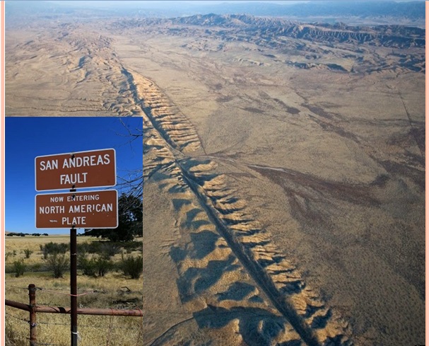
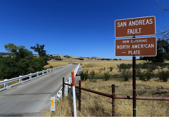
San Andreas fault plate boundary
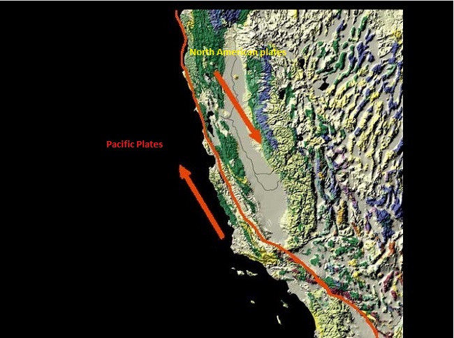
The San Andreas Fault is a transform fault between the Pacific Plate and the North American Plate. The Fault is a Strick-slip fault that slides from one to another. It slices California in two from Cape Mendocino to the Mexican border. San Diego, Los Angeles, and Big Sur are on the Pacific Plate while San Francisco, Sacramento, and the Sierra Nevada are on the North American Plate. Many world-famous features like Desert Hot Springs, San Bernardino, Wrightwood, Palmdale, Gorman, Frazier Park, Daly City, Point Reyes Station, and Bodega Bay lie squarely on the fault line. San Andreas Fault is considered one of the most dangerous faults in the world because it is responsible for several earthquakes over the years.
How was the San Andreas fault formed?
San Andreas fault is an example of a Transform Fault, where two tectonic plates slide past one another. At the San Andrea fault, both plates Pacific and North America are slowly moving past one another at a couple of inches a year. When strain is built-up in the Upper mantle, that breaks the rock along the fault, and the plates slip a few feet. The breaking rock sends out waves in all directions, and earthquakes are generated on the Earth’s surface.
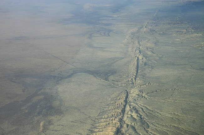
In many places like the Carrizo Plain and the Olema Trough, the fault is easy to see as a series of scarps and ridges. In other places, it is more subtle because plates are not moving for many years. Many of the roads along the fault cut through great mountains of gouge and crumbled rock that has been pulverized by the moving plates. It can be easily seen in the cities like San Bernardino and Los Angeles Counties.
The SAF is about 965 kilometres long and roughly 16 kilometres deep. The plates are continually moving but where they touch each other, they get stuck. when the rest of the surrounding plates move, the stuck parts deform and compress like a spring and build up stress in the rocks along the fault. When the rock breaks or slips, the sudden plates move, causing produce seismic waves that travel through the ground and shake the surface. The entire process is called elastic rebound theory.
How long is the San Andreas fault
The San Andreas Fault boundary is one of the most intensely studied faults on the earth. It is a continental transform fault that separates the Pacific plate from the North American plate along its entire trace. Its northern point begins at the Mendocino triple junction near Cape Mendocino. This is the location where the North American, Pacific, and Juan de Fuca plates all meet at a point or at least within a small area.
Here the San Andreas plate boundary merges with the Mendocino fault zone and extends out to sea as a transform fault that separates the Juan de Fuca plate from the Pacific plate. Fault plane again reaching land at Point Arena. From Point Arena, it forms a straight lineament through Tomales Bay into San Francisco and then through the Santa Cruz Mountains to an area east of Monterey Bay where the fault makes a slight bend to the east.
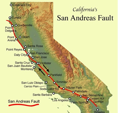
It then maintains a straight line diagonally through the Coast Ranges to the southern end of the Central Valley between Bakersfield and Santa Barbara. From here the San Andreas Fault makes a second larger and more abrupt “Big Bend” to the east at Mt. Pinos. After about 600 miles, The Fault ends along the eastern shoreline of the Salton Sea near the town of Bertram.
Also, read- The Great Appalachian Mountain range of the USA and its Geology
Fault Lines in the US
The San Andreas Fault forms the tectonic boundary between the Pacific Plate and the North American Plate, and its motion is horizontal. The fault divides into three segments, each with different characteristics and a different degree of earthquake risk. The slip rate along the fault ranges from 20 to 35 mm per year. This is the reason the San Andreas Fault is known as the most dangerous fault in the world. The 1906 San Francisco earthquake, is the best example of its dangerousness. Because San Andreas Fault is a transform fault there is various small fault that is known for disastrous earthquakes in the reason.
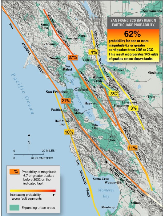
The Hayward Fault is parallel to the San Andreas Fault, which lies offshore and through the San Francisco Peninsula. The Hayward Fault is a right-lateral strike-slip fault capable of generating destructive earthquakes. This fault is about 119 km long, situated mainly along the western hills on the east side of San Francisco Bay. It runs through densely populated places, including Richmond, El Cerrito, Berkeley, Oakland, San Leandro, Castro Valley, Hayward, Fremont, and San Jose. To the east of the Hayward Fault lies the Calaveras Fault. In 2007, the Hayward Fault was discovered to have merged with the Calaveras Fault east of San Jose at a depth of 6.4 kilometres. with the potential of creating earthquakes much larger than previously anticipated.
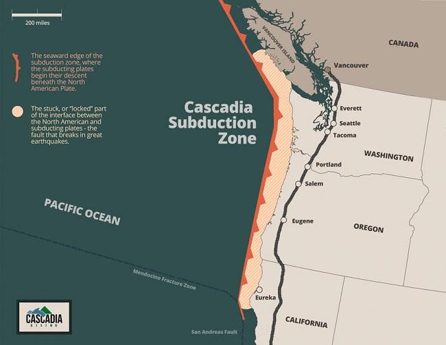
The west coast fault also Known as the Cascadia subduction zone, is another major fault in the U. It runs for 1126 kilometres off the coast of the Pacific Northwest, beginning near Cape Mendocino, California, continuing along Oregon and Washington, and terminating around Vancouver Island, Canada. See the Hayward fault map below.
San Andreas fault and earthquake
The San Andreas Fault is a group of faults (San Andreas fault system). It has been noticed worldwide since the disastrous 1906 San Francisco earthquake. San Andreas fault line passes through California, a highly-populated state. There are many roads in California that snake along the fault line. During the 1906 earthquake in the San Francisco region, roads, rows of trees, and bushes that crossed the fault were offset several meters, and the road across the head of Tomales Bay was offset almost 21 feet. In each case, the ground west of the fault moved relatively northward. Geologists believe that the total accumulated displacement from earthquakes and creep is at least 563 kilometres along the San Andreas fault since it came into being about 30 million years ago.
The places along the fault line are uncrowded and peaceful, perfect for a family vacation. There is an abundant place for camping, bird watching, wildflowers and wildlife, rock collecting, and natural beauty along the Fault plane. A number of State and National parks are located along the fault line. All it takes is a good Geological map, and a desire to see the world’s most famous fault. See the San Andreas fault system on the map.
Parkfield
The town of Parkfield sits close to the fault line. Those visiting will find themselves on the eastern side of the San Andreas Fault line and will be able to see the bridge that has undergone five rebuilds due to earthquakes.
Palm Springs
Palm Springs is Arguably one of the best places to see the San Andreas Fault. here visitors can see hot springs that bubble up through fissures and create tube-like holes in the earth. In this place, visitors can stand directly on top of the fault line at 1000 Palms Canyon.
Carrizo Plain
Carrizo Plain is the best place to see the Fault system. This can be found between I-5 and U.S. Highway 101. Carrizo plain paints a fairly dramatic picture of the fault. Occasionally, steam beds can be seen from the air, and the fault line runs partially underneath Soda Lake.
Trancos Ridge
Visitors can hike the Trancos Ridge in the Santa Cruz Mountains. Here people may see random gullies, valleys, water beds, and divets that do not run parallel to the trail.

