Drakensberg Mountains
The Great Escarpment is one of Africa’s most striking topographical features and a defining natural landmark of Southern Africa. Encircling the high central plateau, it runs along the continent’s southern, eastern, and western edges, forming a dramatic boundary between the plateau and the coastal plains.
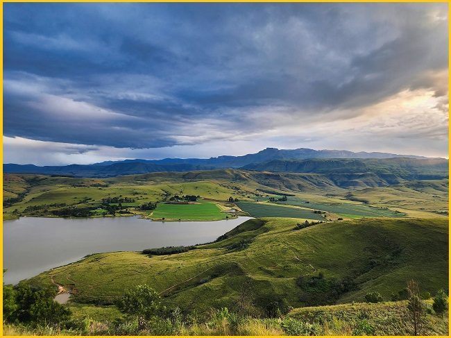
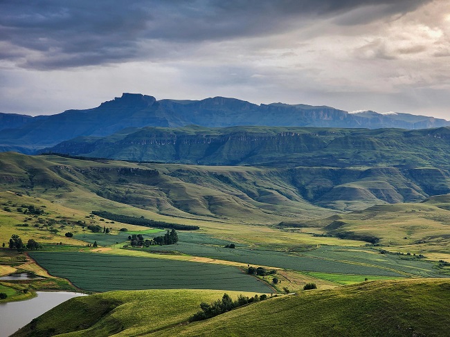
Different sections of the escarpment are known by different names, with the eastern portion—the most famous—called the Drakensberg. This range includes Southern Africa’s highest mountains, with several peaks rising above 3,480 metres. Stretching for more than 1,000 kilometres from northeast to southwest, the Drakensberg is renowned for its spectacular scenery, dramatic cliffs, and rich biodiversity. It also preserves a wealth of cultural heritage, including ancient San rock and cave art created thousands of years ago.
The Drakensberg Mountains stretch for more than 1,000 kilometres and are marked by jagged peaks, earning them the name “Barrier of Up-pointed Spears.” They form the most elevated section of the Great Escarpment, with summits reaching up to 3,482 metres above sea level.
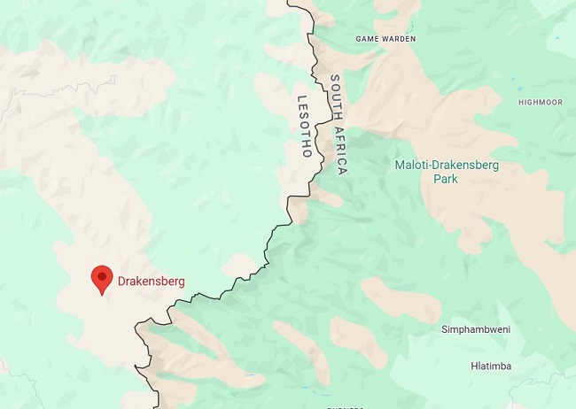
Drakensberg Mountains Map
Stretches over 1,000 km from the Eastern Cape in the south to Limpopo Province in the north. Forms part of the Great Escarpment along South Africa’s eastern edge and Lesotho’s western border.
The highest portion of the range, located in southern and eastern Lesotho, is defined by a sandstone base topped with eroded basalt. Massive fractured blocks create the dramatic eastern scarp, rising 3,000–3,300 metres along the KwaZulu-Natal–Lesotho border, and the southern scarp, reaching 2,400–3,000 metres along the Eastern Cape–Lesotho border. Beneath these towering cliffs lie sandstone terraces that host a series of scenic national parks and game reserves, adding both ecological and cultural value to the region.
Geology
The Great Escarpment was formed over 180 million years ago when mantle plumes caused the continental crust in Southern Africa to bulge. Rift valleys later developed on either side of this uplift, and as they flooded, their steep walls became the escarpment that now encircles much of Southern Africa. With the widening of the Southern, Indian, and Atlantic Oceans, the subcontinent entered a tectonically dormant phase, experiencing neither volcanic nor significant earthquake activity. Erosion, however, has continued without interruption, gradually wearing down the plateau and depositing sediments onto the continental shelf surrounding the region.
Southern Africa’s eastern region has undergone additional uplift, causing most plateaus to rise above 1,000 metres despite extensive erosion. The Great Escarpment reaches its highest elevations in the east and gradually slopes toward the south and west. The Drakensberg Mountains exhibit a rugged, jagged appearance due to their erosion-resistant upper surfaces. In Lesotho, deep erosion gullies carve out valleys that serve as major tributaries feeding into the Orange River.
World Heritage Site
The Maloti-Drakensberg Park is a transboundary World Heritage Site comprising the uKhahlamba Drakensberg National Park in South Africa and Sehlabathebe National Park in Lesotho. Renowned for its outstanding natural beauty, the park features soaring basalt cliffs, dramatic cutbacks, golden sandstone ramparts, and striking natural formations such as sculpted arches, caves, cliffs, pillars, and rock pools.
Also Read- Miyazaki Prefecture: From Takachiho Gorge to Aoshima Island
Its wide range of habitats supports a remarkable diversity of flora, including many endemic and globally significant plant species. The park also provides refuge for endangered wildlife such as the Cape vulture (Gyps coprotheres) and the bearded vulture (Gypaetus barbatus). Sehlabathebe National Park is additionally home to the Maloti minnow (Pseudobarbus quathlambae), a critically endangered fish found nowhere else.
Beyond its ecological importance, the park is culturally significant. It contains hundreds of caves and rock shelters, hosting the largest and most concentrated collection of rock art south of the Sahara. These paintings, created by the San people over a span of 4,000 years, reflect their spiritual traditions and deep connection to the landscape.


