India has some world-famous tectonic elements that affect the Geological history of the Indian sub-continent in great amounts. Today we discuss these tectonic elements in detail.
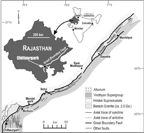
Great Boundary Fault
Great Boundary Fault at Satur, Bundi district, Rajasthan is characterized by a faulted boundary between Pre-Aravallis and Upper Vindhyans having an NNW‐SSE trend. Great boundary fault is of 500 miles length and 5000 feet throw which has brought the sandstones of the Bhander series (Upper Vindhyan) in contact with the highly folded and foliated schist of Aravalli. It is roughly parallel with the course of River Chambal. GBF represents a zone of disruption constituted by a number of parallel and oblique faults resulting in a step-like feature. The deformed limestone at the site is worth viewing. The Great Boundary Fault is best studied at about 10 km NW of Bundi on Jaipur Road.
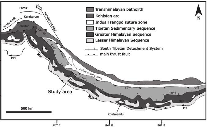
Main Boundary fault
main boundary fault comprises a series of more or less parallel faults that exhibits similar tectonic and stratigraphic Peculaliarites and separates the Siwaliks from the earlier tertiary and older rocks. The Main Central Thrust is a major geological fault where the Indian Plate has pushed under the Eurasian Plate along the Himalayas. The fault slopes down to the north and is exposed on the surface in an NW-SE direction (strike). It is a thrust fault that continues along 2200 km of the Himalayas mountain belt.
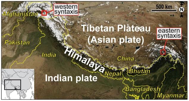
Syntaxial bend
Syntaxial bends are deep knee-bend flexures that occurred at the extreme ends of the west and east of the Himalayas due to the southward turn of the mountain chain. The western syntaxial bend is near Nanga Parwat, where the Indus river makes 500 meters deep gorge, the Himalayas takes a sudden southward turn that bends like a hairpin. The eastern syntaxial bend is at Namcha Barwa where the Brahmaputra rivers make a gorge, the Himalayas takes a southward direction, these bends are called Syntaxial Bends of the Himalayas. The formation of this syntaxial bed is believed to be the result of the rotational movement of the Indian plate during the Oligocene times.
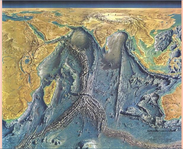
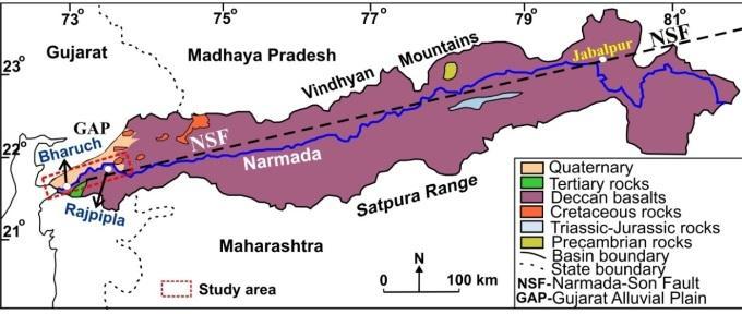
Narmada-Son Lineament
Narmada son lineament is generally a zone of crustal weakness (Rift valley) that has been activated in the geological past. It is reflected in a gravity anomaly map as a narrow belt of crustal subsistence along the Narmada valley covered by 300 m. Of sediments in the east and 30-35 m. In the center. The rift is offset by a number of transverse tear faults. There is a kine of carbonatite bodies and alkali syenites parallel to the rift valley. The faults which border the rift served as channels for the outpouring of Deccan lavas.
According to west and Auden, the lineaments is a kine of fundamental tectonic feature connected with some primary weaknesses of the archean crust, which has influenced some primary weakness of the archean crust, which had influenced the deposition and deformation of the Vindhayan and Gondwana rocks. The available geophysical data and pieces of evidence from plate tectonics suggested that the Narmada-Son lineament has originated due to Wrench Fault Tectonism with associated warping and Subduction.
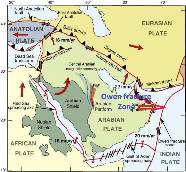
Owen Fractur zone
The Arabia-India plate motion is currently accommodated along the Owen Fracture Zone(OFZ) in the NW Indian Ocean. The OFZ belongs to the large strike-slip plate boundaries like the San Andreas, Dead Sea, North Anatolian, and Alpine faults. Owen fracture zone terminated against the sediment-filled Makran subduction zone. It has right -laterally offset The Carlsberg ridge and continues southwestward demarcating the faulted, straight coast of Malagasy island. It is believed that the Chaman fault system is the landward northerly expression of the Owen fracture zone.
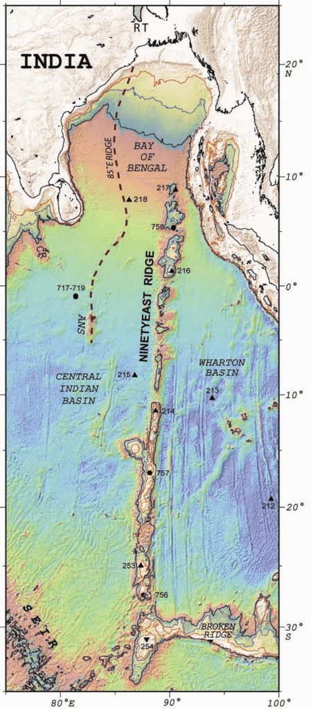
90 degree E Ridge
90 degree is a 4800 km long fracture or leaking transform fault running parallel to the island-arc chain of the Andaman and Nicobar. it extends northwards and joins with the Indo-Burman border fault. Its northern end is buried under the Flysch of the Ganga basin. The northern part of the 90 degrees Eeay ridge coincides with the Sumatra-java-Andman Subduction zone which is filled by sediments of the Bengal Fan.
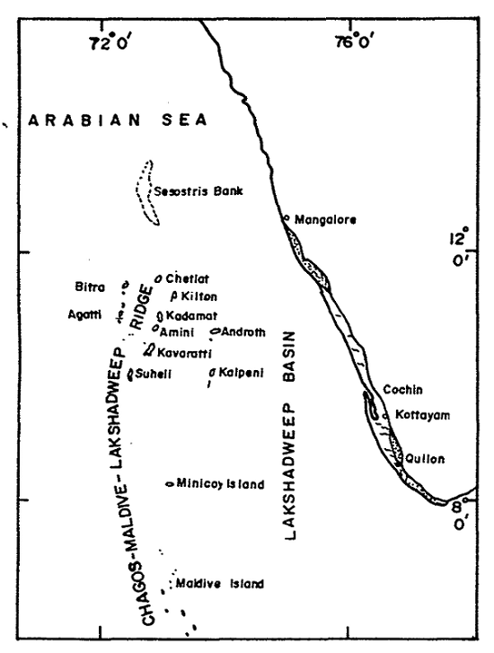
Lakshadweep-Chagos Zone
Lakshadweep-Chagos zone is a transform fault that occurs in the middle of the Indian ocean and has offset the SE Indian ridge from the Carlsberg Ridge. It separates the Chagos islands from the Mauritian Plateau. It splits the Indian Ocean plate into two major segments.
Ganga Basin
The Ganga basin occupies 270000 Sq.km. area in North India. in the west, the Ganga basin is defined by the Delhi metasediments which form a subsurface ridge called the Delhi-Haridwar ridge which is covered by alluvium. in the east the Ganga basin is limited by another ridge of Satpura Metamorphics called the Monghyr-Sahara ridge.
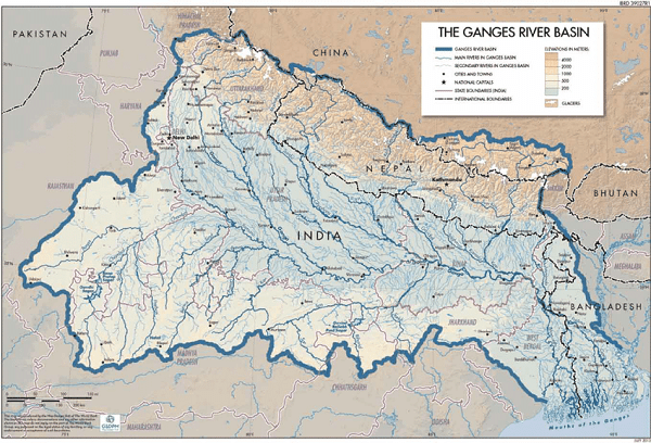
In the southern region, it is demarcated by the Bundelkhand Gneissic Granites and Precambrian sediments the Ganga basin is filled with alluvium of great thickness ranging in age from Pleistocene to recent. Edward Suess recognized the Ganga basin as a Fore deep with reference to the Himalayas but Burrard felt that it is a rift. Tectonically, the Ganga basin represents a large-scale depression of the Vindhyan syncline which shows a northward continuation of Vindhyan sedimentation.
Also, Read- Lava Beds National Monument of California-A great Volcanic wonderland


