Natural Coal Fires
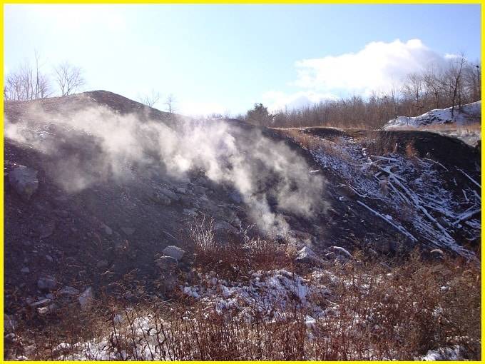
Natural coal fires are among Earth’s most intriguing yet destructive geological phenomena, in which coal-bearing rocks ignite and continue to burn for years, decades, or even centuries. These fires begin when exposed coal seams encounter oxygen and an ignition source, such as lightning, wildfires, spontaneous combustion, or human activities like mining. Once started, the flames creep slowly through underground coal layers, often remaining concealed beneath the surface.
The burning rocks can reach extremely high temperatures, emitting smoke, toxic fumes, and greenhouse gases such as carbon dioxide and methane. Intense heat transforms the surrounding rocks, firing clays into brick-like material and forming distinctive minerals and reddish, fused rocks known as clinker. Over time, the land above these fires may fracture, sink, or collapse, creating serious hazards for ecosystems, infrastructure, and human settlements.
Natural coal fires occur in many regions worldwide, including India’s Jharia coalfield, Centralia in the United States, as well as parts of China, Indonesia, and Australia. Although they pose major environmental and economic challenges, these fires also provide important insights into combustion dynamics, climate effects, and long-term geological change.
Burning rocks serve as a powerful reminder that Earth is a dynamic planet, where fire and stone can coexist, quietly reshaping landscapes beneath our feet.
List of Mine Fires
Australia
Burning Mountain – A naturally occurring, slow-burning underground coal seam that has been continuously burning for more than 5,500 years.
Hill End Colliery fire – A coal-seam fire at Cessnock, New South Wales, which burned from at least August 1930 and likely continued until June 1949.
Blair Athol coal mine – A coal mine near Clermont, Queensland, that has experienced several fires, including one underground fire that persisted for 54 years.
China
China, the world’s largest coal producer with an annual output of about 2.5 billion tons, faces a severe problem from coal fires. It is estimated that 10–200 million tons of coal are wasted each year through uncontrolled burning, while a similar amount becomes inaccessible for mining. These coal fires form a belt stretching across northern China, where more than one hundred major fire areas have been identified, each comprising numerous individual fire zones. The fires are primarily concentrated in the provinces of Xinjiang, Inner Mongolia, and Ningxia.
America
Many coalfields in the United States are prone to spontaneous combustion. In Pennsylvania, 45 fire zones have been identified, the most notable being the Centralia mine fire in the anthracite coal region of Columbia County, which has been burning since 1962. Another early example is the Burning Mine near Summit Hill, which ignited in 1859.
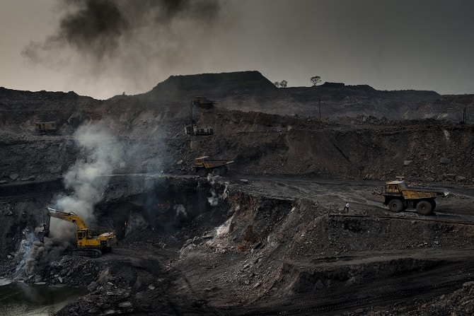
India
In India, as of 2010, 68 underground fires were active beneath an area of about 58 square miles (150 km²) in the Jharia coalfield of Dhanbad, Jharkhand. These mine fires, which began in 1916, are rapidly destroying the country’s only major source of prime coking coal and causing extensive land subsidence and environmental pollution in the surrounding areas.
Origin
Natural Coal fires can be broadly classified into two types: near-surface fires, where coal seams reach the surface and receive oxygen directly from the atmosphere, and deep underground mine fires, where oxygen is supplied through mine ventilation systems.
Mine fires often originate from industrial accidents, typically involving gas explosions. Historically, some were deliberately triggered when authorities attempted to halt illegal or bootleg mining by sealing or blasting mine entrances. In more recent times, several mine fires have been ignited by trash burning in landfills located near abandoned coal mines. A well-known example is the Centralia, Pennsylvania fire, which has been burning continuously since 1962. Of the hundreds of active mine fires in the United States today, the majority occur in Pennsylvania.
In addition to human-caused incidents, some coal-seam fires arise naturally. Certain types of coal, particularly brown coal, can self-ignite at temperatures as low as about 40 °C under favorable conditions of moisture and grain size. These fires typically begin a short distance below the surface, at depths where coal permeability allows air to enter but ventilation is insufficient to dissipate the heat produced. Self-ignition was a recognized hazard during the era of steamships. Another known cause occurs when mining operations breach high-pressure methane pockets; the sudden gas release can generate static electricity, igniting the methane and triggering a coal explosion and fire.
Also Read- Future of Rare Earth Minerals (REMs) and Green Technologies
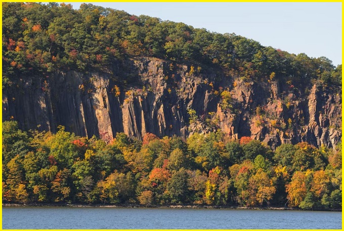
Wildfires—whether sparked by lightning or other causes—can ignite coal seams near the surface or at mine entrances. Once ignited, the smouldering fire may slowly spread along the seam, causing ground subsidence that exposes additional coal layers to oxygen and increases the likelihood of future wildfires when the fire reaches the surface again. In the American West, prehistoric clinker outcrops are remnants of ancient coal fires; these heat-altered rocks resist erosion more effectively than the surrounding material, forming prominent buttes and mesas. Australia’s Burning Mountain, believed to be the world’s oldest known coal fire, is estimated to have been burning continuously for about 6,000 years.
Natural coal fires: Hazards
Natural Coal fires pose severe health and safety risks, degrading the environment through the release of toxic fumes, reigniting grassland, brush, or forest fires, and triggering ground subsidence that damages surface infrastructure, including roads, railways, pipelines, power lines, bridges, buildings, and homes. Whether ignited by human activities or natural processes, coal-seam fires can persist for decades, centuries, or even millennia, ceasing only when the fuel is exhausted, a permanent groundwater table is reached, the burn advances beyond the ground’s ability to subside and vent gases, or deliberate human intervention occurs. Because these fires burn underground, they are tough and expensive to control and are rarely extinguished by rainfall. Coal fires also share strong similarities with peat fires.
Worldwide, thousands of underground coal fires are currently active, with the most severe impacts seen in rapidly industrializing, coal-rich countries such as China. Globally, emissions from coal fires are estimated to release about 40 tonnes of mercury into the atmosphere each year and to account for nearly three percent of annual carbon dioxide emissions.
Natural Coal fires not only cause severe environmental damage and pose serious risks to human health through uncontrolled burning, but they also lead to the loss of valuable non-renewable resources. Estimates suggest that between 20 million and 600 million metric tonnes of coal are destroyed by these fires each year.

Identification and Prevention of Coal Seam Fires
Identification
Infrared thermal imaging is a passive infrared night-vision technology based on the principle that all objects with temperatures above absolute zero (−273 °C) continuously emit infrared radiation. This radiation contains information about an object’s thermal characteristics, providing an objective basis for using infrared techniques to identify temperature variations and thermal distribution patterns of different targets. In this process, a photoelectric infrared detector converts the infrared energy emitted by heated portions of an object into electrical signals, which are then processed by an imaging system to accurately reproduce the spatial distribution of surface temperatures. After signal processing, a thermal image video is generated and displayed, resulting in an infrared thermal image that reflects the object’s surface thermal field.
Read- Geotourism And Modern Geotechniques
UAV-mounted thermal imagers are advanced infrared imaging systems that can be remotely controlled and are particularly effective for detecting high-temperature zones in areas that are difficult or unsafe for human access. Taking advantage of these capabilities, a M300 RTK UAV thermal imager was first deployed to survey the southern surface area to obtain an initial understanding of the outcrop fire zone. The M300 RTK UAV offers strong performance and supports the Zenmuse H20 hybrid sensor, which integrates a laser rangefinder, zoom camera, wide-angle camera, and thermal imaging camera. This configuration enables rapid and accurate detection of high-temperature areas associated with surface coal fires.
Prevention
In the treatment of Natural coal fire areas, a variety of techniques are commonly employed, including stripping, yellow mud injection, inert gas injection, and loess covering. Shao et al. applied three-phase foam and water-mist technology to suppress upper-level fires in abandoned roadways and loose zones, successfully controlling coalfield fires at the Anjialing open-pit mine in China.
Tan et al. introduced sodium silicate gel—a pressurized, moisture-retaining sealing material—which enabled rapid cooling and effective extinguishment of the Fukang coal fire in Xinjiang. Zhai and Deng proposed a novel composite firefighting gel for outcrop fires and provided a detailed account of its characteristics, performance, and applications. Bustamante et al. identified several materials with fire-prevention potential, including diluted bitumen and brine (as combustion inhibitors), cement or slaked lime, fine sand cement, and clinker–slaked lime mixtures, noting that bitumen–brine combinations exhibited particularly strong adhesion and durability within coal seams. Deng et al. successfully applied composite fly ash gel to control coal fires at Haibaoqing.
Most previous studies relied on a single method for detecting outcrop fires, such as infrared remote sensing, surface temperature measurement, magnetic surveys, electrical methods, or radon monitoring. However, because each technique has inherent strengths and limitations, using only one method makes it difficult to accurately delineate the extent of a fire zone. Similarly, adopting a single prevention or extinguishing approach may be inefficient and could lead to unnecessary resource consumption.


