Most Prominent Geological feature on Earth-The Mid Atlantic ridge valley
What is Mid Atlantic Ridge
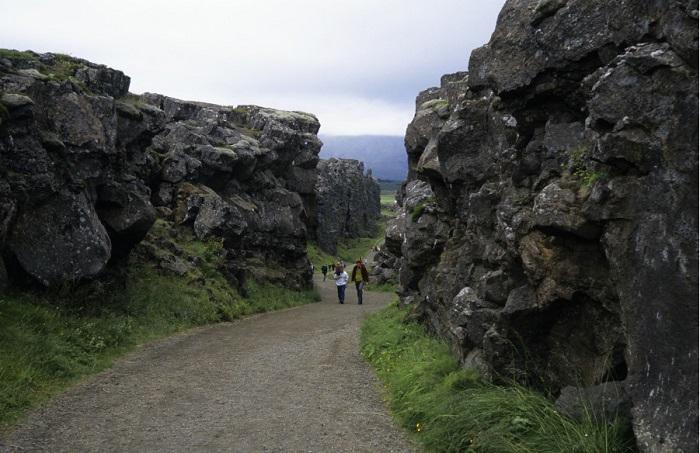
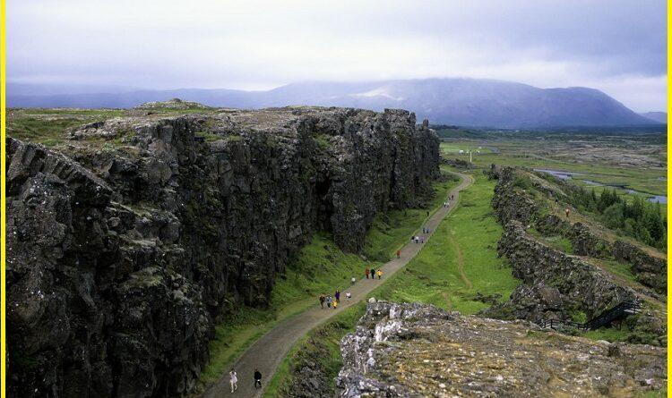
The Mid-Atlantic Rift is an active spreading rift (Constructive plate Boundary) separating two of the largest continental plates in the world: the North American Plate and the Eurasian Plate. Although the Mid-Atlantic Ridge is mostly an underwater feature, portions of it extend above sea level, for example in Iceland. The ridge has an average spreading rate of about 2.5 centimetres per year. The Mid Atlantic Ridges are about 3 km in height above the ocean floor and 1000 to 1500 km wide, have numerous transform faults and have an axial rift valley along their length. The place where the Mid-Atlantic Ridge is best seen is at Thingvellir National Park, in southwestern Iceland. The mid-Atlantic ridge valley forms due to the movement of the tectonic plates. When two plates move apart, magma rises up resulting in basaltic volcanism and new Crust formation. Most of the spreading is under the floor of the Atlantic Ocean, and part of the longest mountain range in the world.
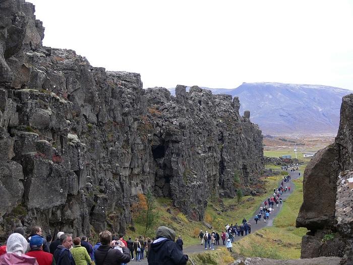
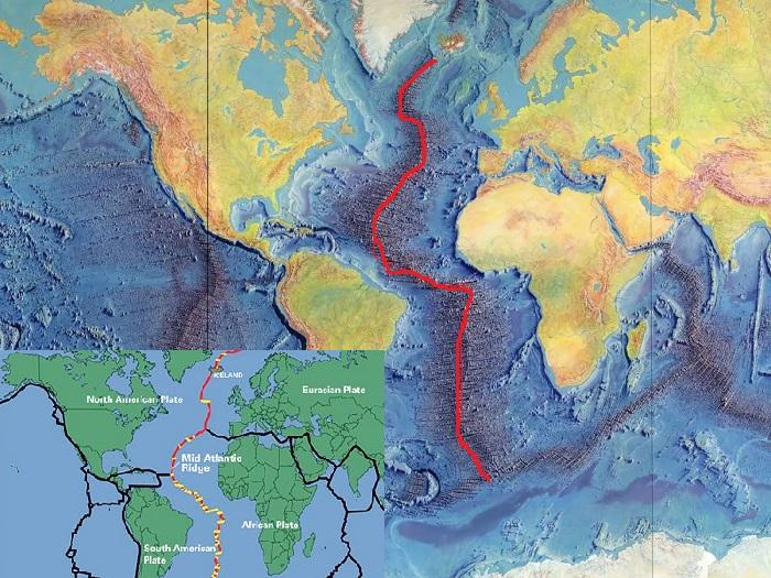
The Mid-Atlantic ridge was discovered in the 1950s. Its discovery led to the theory of seafloor spreading and the general acceptance of Wegener’s theory of continental drift. The Mid-Atlantic Rift (MAR) separates the North American Plate from the Eurasian Plate in the North Atlantic, and the South American Plate from the African Plate in the South Atlantic. You can see the Mid-Atlantic Ridge on the world map which is shown in red lines. The mid-Atlantic rift map is separating the north American plate from the Eurasian Plate in the north while the south American plate is with the African plate in the south.
The submarine section of the Mid-Atlantic Ridge in Iceland is known as the Reykjanes Ridge or Neovolcanic Zone. Most of the ridge system is underwater but some form land as a set of volcanic islands of varying size. Notable features are-
- Jan Mayen (Norway)
- Iceland
- Azores (Portugal)
- St Paul’s rock (Brazil)
- Ascension Island (UK)
- St Helena (UK)
- Tristan da Cunha (UK)
- Gough Island (UK)
- Bouvet Island (Norway)
These are the same Island that is on the World Heritage List-
- Pingvellir National Park, Iceland
- The landscape of the Pico Island Vineyard Culture Portugal
- Gough and the Inaccessible Islands United Kingdom
- Brazilian Atlantic Islands: Fernando de Noronha and Atol das Rocas Reserve, Brazil
Geology of Mid-Atlantic ridge
The Mid-Atlantic rift valley sits atop a geologic feature known as the Mid-Atlantic Rise, which runs the length of the Atlantic Ocean. This bulge is thought to be caused by upward convective forces in the asthenosphere pushing the oceanic crust and lithosphere. This divergent boundary was first formed in the Triassic period when a series of three-armed grabens coalesced on the supercontinent Pangaea to form the ridge. Usually, only two arms of any given three-armed graben become part of a divergent plate boundary. The failed arms are called Aulacogens, and the aulacogens of the Mid-Atlantic Ridge eventually became many of the large river valleys seen along the Americas and Africa including the Mississippi River, Amazon River and Niger River. The Mid-Atlantic ridge (rift valley) is an example of a Constructive Plate boundary where plates are moving apart and making a new crust.
What is the mid-ocean ridge?
The mid-ocean ridge is the most extensive chain of mountains on Earth, stretching nearly 65,000 kilometres. The massive mid-ocean ridge system is a continuous range of underwater volcanoes that wraps around the globe like seams on a baseball. Mid-ocean ridges occur along divergent plate boundaries, where a new ocean floor is created as the Earth’s tectonic plates spread apart. As the plates separate, molten magma rises to the seafloor, producing enormous basalt magma. The speed of spreading affects the shape of ridge-slower spreading rates resulting in steep, irregular topography while faster spreading rates produce much wider profiles and more gentle slopes.
Two well-studied mid-ocean ridges within the globe are the Mid-Atlantic Ridge and the East Pacific Rise. The Mid-Atlantic Ridge runs down under the Atlantic Ocean, slowly spreading at a rate of 2 to 5 centimetres per year, forming a rift valley that is about the depth and width of the Grand Canyon.
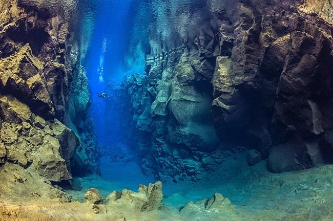
Another, the East Pacific Rise is spreading quickly, at rates of 6 to 16 centimetres per year. Due to the fast-spreading rates, there is no rift valley in the Pacific, just a smooth volcanic summit with a crack along the crest that is much smaller than the Atlantic rift valley. Despite being such a prominent feature on our planet, much of the mid-ocean ridge system remains a mystery.
History of the Mid Ocean Ridge?
Around the 1960s, scientists mapped the Earth’s ocean floors, which revealed a seismically-active central valley, as well as a network of valleys and ridges. They also discovered that the ridge was part of a continuous system of mid-ocean ridges that extended across the entire ocean floor, connecting all the divergent boundaries around the planet.
Much like the “Pacific Ring of Fire“, the discovery of the Mid-Atlantic Ridge has helped inform our modern understanding of the world. This discovery also led to new theories in terms of geology and planetary evolution. For instance, the theory of “seafloor spreading” was attributed to the discovery of the Mid Oceanic Ridge (MAR), as was the acceptance of continental drift and plate tectonics. It also led to the theory that all the continents were once part of the subcontinent known as “Pangaea”, which broke apart roughly 180 million years ago.
Read More- Why is this ‘Fantastic Jurassic Coast, England’ known as a Mesozoic masterpiece
Basically, it is responsible for the fact that the Americas have been drifting away from Africa and Eurasia for millions of years, the formation of Australia, and the collision between the Indian Subcontinent and Asia. Someday, millions of years from now the process of seafloor spreading will cause the Americas and Asia to collide, thus forming a new supercontinent- “Amasia”.
How to reach Mid-Atlantic ridges Reykjanes, Iceland
The Reykjanes Peninsula where The Mid-Atlantic Rift rises out of the Sea is the best viewable site. Reykjanes Peninsula is home to Keflavik International Airport and this is the nearest airport to reach the site.
Sources- UNESCO.ORG, Earthguide.ucsd.edu, universetoday.com, eos.org

Pingback: The Heaven of Gorges-Karijini National Park Australia - Geotourism
Pingback: How To Reach Ice Cave Skaftafell Iceland Better Than Anyone Else - Geotourism