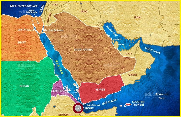
What is the Afar Triple Junction
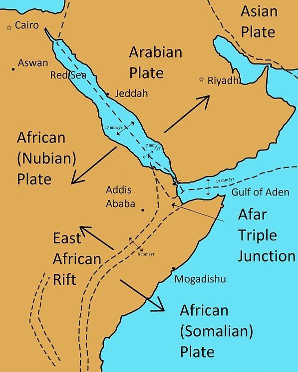
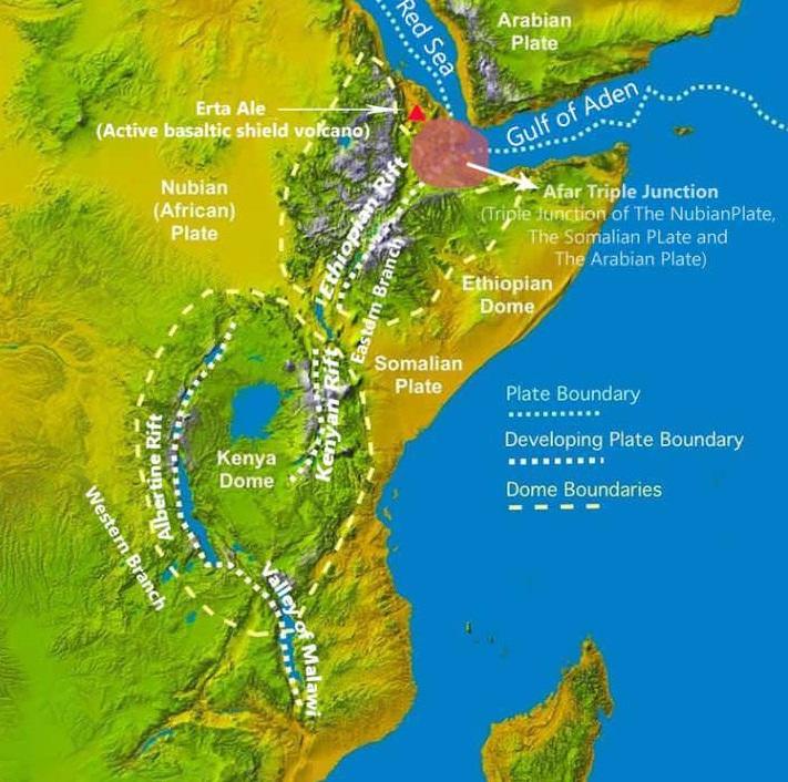
The Afar Triple Junction is located along a divergent plate boundary dividing the Nubian, Somali, and Arabian plates. This area is considered a present-day example of continental rifting leading to seafloor spreading and producing an oceanic basin. Here, the Red Sea Rift meets the Aden Ridge and the East African Rift. The latter extends a total of 6,500 kilometres from the Afar Triangle to Mozambique. The connecting three arms form a triple junction. The northernmost branching arm extends north through the Red Sea and into the Dead Sea, while the eastern arm extends through the Gulf of Aden and connects to the Mid-Indian Ocean ridge further to the east. Both of these rifting arms are below sea level and are similar to a mid-ocean ridge. The third rifting arm runs south extending around 4,000 kilometres through the countries of Kenya, Uganda, the Democratic Republic of Congo, Rwanda, Burundi, Tanzania, Zambia, Malawi and, finally, Mozambique. This southern rifting arm is better known as the East African Rift or the East African Rift System which includes the Afar Triangle.
Geological Setting
The Afar region in Northern Ethiopia is the centre of a “Y” shaped rift system, where the continental lithosphere is being split. This is part of the Great African rift system. In this place, The Arabian Plate is rifting away from the African plate along an active divergent plate ridge system. This formed the Red Sea and the Gulf of Aden. The rifting of the African plate extends southwards where it itself splits into two new plates- the Nubian and Somalian Plates. This point in the Afar region where all three plates meet is called a Triple Junction. In time, as the Nubian and Somalian plates move further away from each other, the area between them will grow thinner and drop below sea level. New ocean lithosphere may form along the centre of the rift, producing a new narrow ocean basin with the mid-ocean ridge. The orientation of the rifts, highlands and associated volcanic activity suggests that the rifting is possibly formed by a rising mantle plume, beneath the Afar region where an upwelling mantle plume is forcing up the region.
This area is an example of the last stage of continental rifting and the early stage of seafloor spreading, leading to the creation of oceanic crust. The Afar hotspot is located at the triple junction between the Red Sea rift, the Gulf of Aden and the Ethiopian rift zone. The Red Sea rift is considered the boundary between the Arabian and African (Nubian) plates, whereas the Gulf of Aden separates the Arabian and African (Somalian) plates.
Tectonics of the Afar triple junction
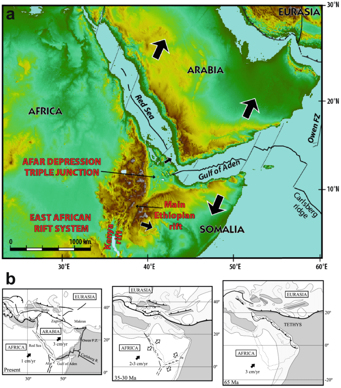
The first rift to open is thought to have been the Gulf of Aden around 30 Ma. Simultaneously, the intense activity of the Afar hot- spot led to a massive amount of flood basalt in the region. The opening of the Red Sea rift is thought to have started between 24 and 21 Ma. This event was followed by high magnetic anomalies and subsequently the opening of the Ethiopian rift between 18 and 15 Ma.
Read more- Joshua Tree Desert and National Park-Best Hiking Trail in the Mojave Desert
Doming and rifting
A rift is a result of the pulling apart or extension of the lithosphere, including the crust, caused by mantle upwelling where hotter asthenosphere magma rises up into the colder lithosphere to stretch and thin it. The triple rift is thought to have begun in the Late Cretaceous epoch to the Paleogene period. At that time the African plate was experiencing far-field stresses caused by portions of the northern boundary of the African plate subducting under the Eurasian plate. Today, the Arabian plate is experiencing a crustal down pull, or slab pull, that has separated from the African plate. At the same time as the subduction in the north, there was mantle upwelling causing the crust to downwarp and swell into domes throughout the East African Rift System. The Kenyan dome has been studied extensively. Other domal uplifts, including the Afar dome beginning 40 Mya. The Afar Depression is a geological depression that ranges in height from 1,000 to −120 m. The area has experienced many This uplift caused massive crustal extension leading to horst and graben structures associated with normal, extensional, faults. The uplift ended in collapse around 25 Mya into the Afar depression covering more than 200,000 km2 and spreading at a rate of 6 to 17 millimetres per year.
The plume is thought to have begun under Lake Tana in Ethiopia. Based on the environmental correlations and current topographic locations of the Jurassic Upper Limestone and Cretaceous Upper Sandstone, the net rock uplift of the Ethiopian Plateau would be 2.2 km since c. 150 Mya. The thinned Ethiopian lithosphere could have resulted in ponding from mantle plume and subsequent uplift.
Afar Depression and Landform
The Afar Depression or Danakil Depression also known as Denakil Plain is a geological depression in the Horn of Africa, where it overlaps Eritrea and the Afar Region of Ethiopia, and slightly touches Djibouti and Somalia. The Afar Depression is the product of a tectonic triple-rift junction and the place of many amazing landscapes and tectonic features Hot springs, a lake and a desert. Volcanoes eruptions separate it from the Red Sea. Nomadic pastoralists, related to the Afar people of Djibouti, are virtually the plain’s only inhabitants.
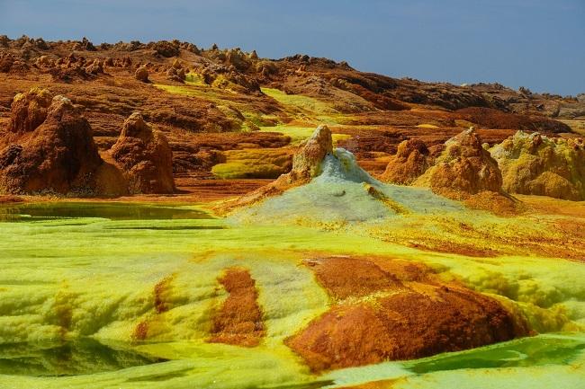
The Afar Depression is a formidable landscape which includes the Danakil Desert and the lowest point in Africa, Lake Asal, less than 155 meters below sea level. Dallol, Ethiopia is also part of the Depression, one of the hottest places year-round anywhere on Earth. The only river that flows into the Depression is the Awash River. It ends in a chain of salt lakes, where its water evaporates as quickly as it is supplied. About 1,200 square kilometres of the Afar Depression is covered by salt, and salt mining remains a major source of income for many Afar tribes.


