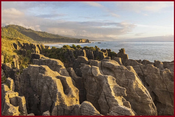
Punakaiki Pancake rocks
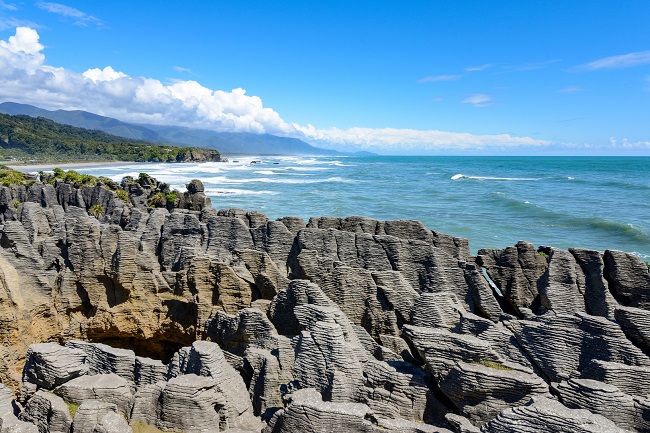
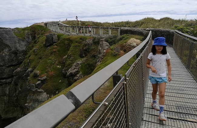
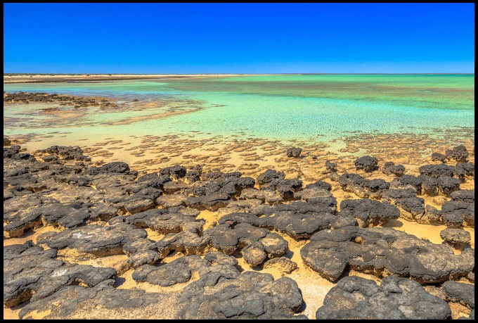
Punakaiki Pancake rocks, A nature work of art began to form about 30 million years ago when the alternating layers of small marine shells and sand became buried and compressed on the ocean floor. the process created multiple layers of hard limestone and softer sandstone. Tectonic activity then lifted the ocean floor high and dry, and the slow process like the rain and the wind began to erode the softer sandstone. The outcome of this activity forms cliffs and ravines with hundreds of horizontal slices along their vertical faces, like huge stacks of pancakes, That’s the name Pancake rock. A well-maintained walkway made to the pancake rocks that leads through native forest before emerging into areas of coastal scrub. The track offers magnificent views of the mountains, the rugged coastline, and the main attraction, the pancake rocks, and blowholes.
Punakaiki Pancake rocks location
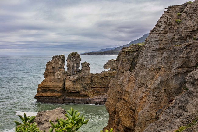
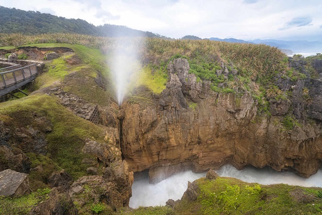
The Pancake Rocks and Blowholes are located at Dolomite Point, adjacent to the village of Punakaiki, in an area that is protected and forms part of the Paparoa National Park. Dolomite Point has a maze of underground passages and large open caverns which face the sea. When there’s a big swell, and the ocean surges into these caverns, water is forced into the passages. As high tide approaches huge geysers of spray burst skywards. The Punakaiki Marine Reserve surrounds the Pancake Rocks and blowholes and covers much of the coastline at the edge of the Paparoa National Park.
Geology
The Punakaiki Pancake is a Limestone rock that has been uplifted and then eroded into the current landforms by a combination of two processes- karst erosion (chemical erosion of the limestone through the action of water flowing in joints and caverns), and coastal erosion (including the collapse of caverns).
Limestone formation
The Pancake Rocks are a heavily eroded limestone formation where the sea bursts through several vertical blowholes by high tide. The limestone was formed in the Oligocene period (around 22–30 million years), a period when most of the continent of Zealandia was submerged beneath a shallow sea. The limestone rocks of the Punakaiki region began forming on the sea floor in warm coastal waters, offshore from a group of low-lying islands. The marine organisms growing in these waters died, and their shells settled on the sea floor along with small amounts of sand and mud. Over millions of years, these shells formed a thick deposit of nearly pure calcium carbonate.
About 25 million years ago, at the beginning of the Miocene, due to the upward movement of the earth’s crust (the Kaikoura Orogeny), Large amounts of sand and mud were eroded from the emerging land and deposited on the sea floor, on top of the shell debris. Over the following 20 million years, as the uplift of the crust continued, The high pressures created by the new layers expelled water from the shelly sediment, and this became cemented and lithified to form limestone rock. In the Pliocene, the Kaikoura Orogeny led to the slow folding and faulting of these sedimentary layers in the Paparoa region, raising them above sea level. Following this uplift, erosion processes stripped away most of the sedimentary rocks which covered the region.
Also, read- 5 best Geological features in Trinidad and Tobago Island
However, Particularly at Punakaiki, a down warping of the crust preserved much of the sedimentary layers. Here the limestone rock appears at the surface at Dolomite Point and erosion has removed all the younger mudstones and sandstones. Subsequent erosion of the limestone headland has created an unusual karst landscape.
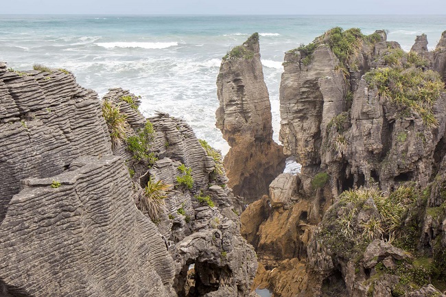
Punakaiki Pancake rocks blowholes
The blowholes at Dolomite Point, Punakaiki have been formed through marine erosion. The action of waves, combined with karst erosion in joints and faults in the limestone rock, leads to the creation of caverns that become sea caves. When the sea cave erodes upwards and towards the land, it creates an opening to the surface. The incoming waves trap air in the sea cave and the air inside the cave becomes compressed, leading to the ejection of air and water upwards from the top of the blowhole. The activity level of the blowhole depends on factors like the tide, sea conditions, and the geometry of the caverns. The best conditions for viewing the blowholes are when there is a high tide and a large incoming ocean swell.
Punakaiki Pancake rocks walk
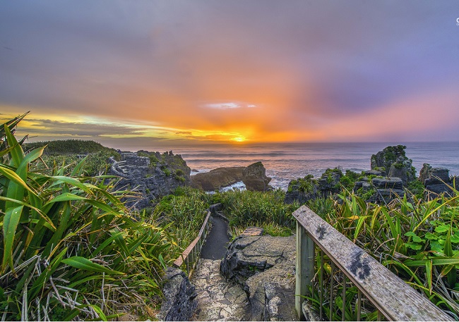
The small west coast settlement of Punakaiki plays host to visitors who come to see the famous pancake rocks and blowholes. Main Activities include walks ranging from a 10-minute stroll on the beach to the Paparoa Track (New Zealand’s newest Great Walk). Punakaiki is located near the center of Coast Road and is one of the most spectacular coastal drives in the world. Travelers can stop and enjoy some of the walks and coastal views on wonderful trips. OtherActivity included horse treks, canoe hire, caving, guided walks, and rafting adventures. The Punakaiki rocks are the top travel sites in New Zealand. Here travelers can find a variety of accommodations, from hostels and homestays to self-contained cottages. there’s also a range of eating places and galleries.
Paparoa National Park
Paparoa national park runs all the way inland from the ocean to the rugged ice-carved Paparoa Mountain Range. The boundaries of the park were carefully established to encompass a complete range of landscapes and ecosystems – from the granite and gneiss summits of the Paparoa Range down to the layered rock formations of Punakaiki. Limestone underlies most of the park and is responsible for the area’s impressive landforms. Sculptured mountain ridges, mysterious river canyons, delicate cave decorations, and bizarre, pancake-like coastal formations.
How to Reach Punakaiki
Punakaiki Pancake Rocks and Blowholes Walk is Located in Paparoa National Park in the West Coast region. Christchurch is the nearest airport to reach Punakaiki pancake rocks. From here one can book a Cab or own a vehicle to drive through Arthur’s Pass. It’s a nice scenic drive with plenty of places to stop, including Castle Hill and Devil’s Punchbowl Falls. The distance between Christchurch and Punakaiki is around 200 km.
Sources-Punakaiki.co.nz, west coast.co.nz, Wikipedia.org,


