Kimberley Australia
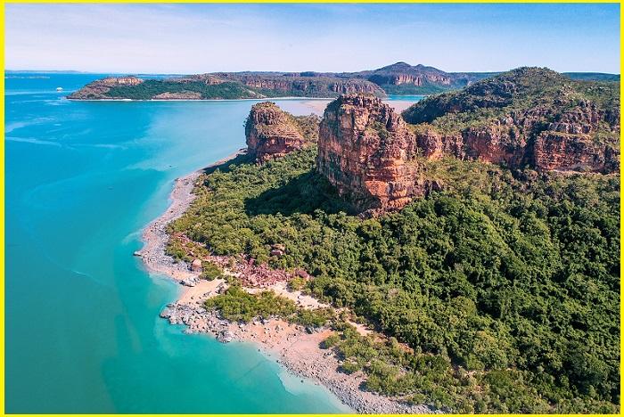
Kimberley coast in Australia is one of the world’s best wilderness regions with its rugged coastline making it a popular small-ship cruising destination. The prolific wildlife, majestic canyons, freshwater swimming holes several outback stations and Australia’s greatest road trips are simply amazing. Despite the area’s remoteness, it’s famous for great food, luxury accommodations, friendly locals and one of the most romantic beach towns on Earth. The Kimberley is the northernmost of the 9 regions of Western Australia. It is bordered on the west by the Indian Ocean, on the north by the Timor Sea, on the south by the Great Sandy and Tanami deserts in the region of the Pilbara, and on the east by the Northern Territory.
Geography and Geology
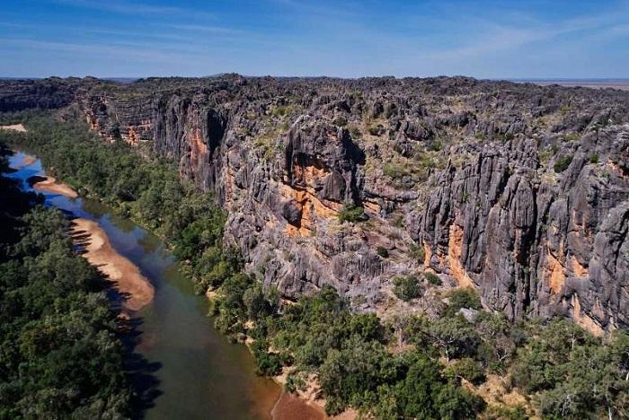
The Kimberley is about three times the size of England, twice the size of Victoria, or just slightly smaller than California. The Kimberley consists of the ancient, steep-sided mountain ranges of northwestern Australia cut through with sandstone and limestone gorges and steep ridges. The extreme monsoonal climate has removed much of the soil from these rock formations. The southern end of the Kimberley is flatter with dry tropical grassland and is used for cattle ranching. Kimberley, the region also consists of clay and Lateritic soil, such as the valleys of the Ord and Fitzroy Rivers in the south. None of the mountains reaches even 1,000 metres, there is so much steep land as to make much of the region difficult to traverse, especially during the wet season. The coast typically steep cliffs in the north but are flatter in the south. During the Devonian period, a barrier reef system formed before a subsequent drop in sea levels over the Kimberley. This reef system was similar to the Great Barrier Reef and is still visible today and known as the Napier Range and the Ningbing Range. Some features are here Tunnel Creek, Windjana Gorge and Geikie Gorge.
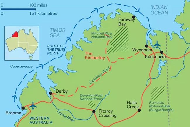
The Kimberley Australia map shows the location of Kimberley and the surrounding area. It is in Western Australia near the Indian Ocean and Timor Sae.
Main Features
Hall’s Creek Province- The Creek has the Oldest rock that was laid down about 2,000 million years ago. Includes Osmond Range, Carr Boyd Range, and the King Leopold Ranges. This portion of the creek is Intensely faulted and folded and has evidence of glaciation 600-800 mya in Hall’s Creek Mobile Zone and near the Lennard River. There was also an intrusion of granite rock such as that near Wombarella Creek.
Kimberley Basin-The Basin is exposed to Precambrian rocks older than about 600 my which are harder and resistant to erosion. Includes King Leopold Sandstone and Pentecost Sandstone. The rocks are the result of weathering and erosion of formation in the Hall’s Creek Mobile Zone. Much of this basin is underlain by Hart dolerite which is exposed in many places. Carson Volcanics, a quartz basalt, which originally covered the King Leopold Sandstones are also exposed in places. Deep weathering in the past and lateralisation have produced a lateritic profile in many parts. Laterites considered to have formed 30-35 mya include bauxite deposits.
Victoria River Basin- Victoria River Basin has a Similar age to the Kimberley Basin. The basin Mainly consists of sandstone with some dolomite.
Canning Basin-This basin formed when the crust subsided southwest of the King Leopold Mobile Zone. The earliest sediments are Ordovician in age about 364 – 357 mya and were part of a fossil barrier reef which includes coral fossils. Napier and Oscar Ranges are the remains of this basin. Broome sandstone is Cretaceous in age about 120 mya, and parts contain fossil dinosaur footprints, including those on Cable Beach.
Ord Basin- Accumulated sediments from about 590 mya to about 213 mya and includes the sediments which formed the Bungle Bungle Range about 400 mya. Like the Canning and Bonaparte Gulf Basins, is underlain in places by Antrim Plateau Volcanics (basalt). Bonaparte Gulf Basin Has some Devonian rocks similar to Canning Basin including the Ningbing Limestone north of Kununurra.
Kimberley Australia tours
Chamberlain Gorge
Chamberlain Gorge is one of the best attractions to the El Questro Wilderness Park with spectacular landscapes. Chamberlain Gorge can be reached within two hours from Kununurra via the legendary Gibb River Road. Boating through the Chamberlain Gorge is a must to do Activity.
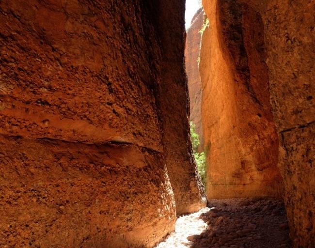
Echidna Chasm
Echidna Chasm is one of Australia’s most spectacular walking destinations. It is along a trail spotted with Livistona palms and through towering bright orange cliffs. The walk is up a creek bed and the walls of the chasm slowly close in on each side. It finally gets to the point where the crevice in which you are walking is only a metre wide and 100 metres high. The light reflects off the orange domes above creating an eerie fluorescent glow on the creek bed below. This is simply one of the most compelling natural wonders of Australia.
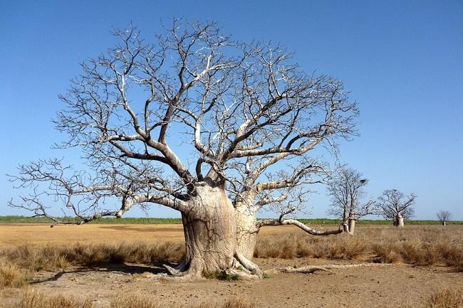
Boabs Tree
The iconic boab tree is unique to the Kimberley and Victoria River Regions of Australia. Boabs require well-drained sandy soil with plenty of water during the growing season. The boab tree is deciduous and will lose its leaves and go into dormancy during the winter months. The flowers of the boab are magnificent and have a wonderful perfume which is enjoyed for a very short time. Boabs have a large tuber which grows up to a 1-meter length of the above-ground portion of the tree.
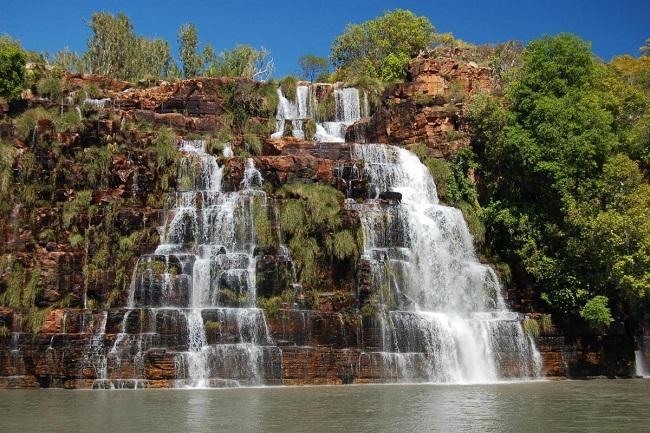
The Kimberley Australia waterfall
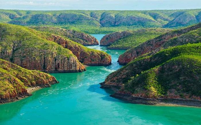
Kimberley Australia waterfall forms Some 20 million years ago, with the tectonic uplifting of the region, when steeper slopes and faster flowing rivers carved the deep gorges seen on the Berkeley and King George Rivers. The unusually straight channel on the Prince Regent River was also created by seawater, a result of weakness in the rocky landscape caused by a geological fracture line. The mammoth Kimberley tides result in deep rivers emptying leaving behind beds of mud, and offshore reefs rising above the horizon It is a natural phenomenon unique to the Kimberley.
Read More-An Extraordinary Feature in Croatia-Eye Of The Earth
King George Water Falls
King George Falls are the most impressive Kimberley waterfalls Fed by the King George River draining across the Gardner Plateau. These twin falls plunge over 80m down vertical sandstone cliffs. A Mist-like spray rose from the base of King George Falls. Visitors can cruise through steep-sided gorges carved by a flooded river system. The landscape is carved out nearly 400 million years ago. King George Falls is Western Australia’s highest twin waterfalls and a Coral Expeditions place.
King Cascade
King Cascade is a beautiful terraced waterfall that is one of the most photographed waterfalls in the Kimberley. The water tumbles down a staggered terrace of Kimberley sandstone. Layer upon layer of ochre-hued and blackened rock sprouts grasses, mosses and ferns in a sort of lush hanging garden. King Cascade is reached via the steep-sided Prince Regent River which snakes down through the Caroline Range and is a remarkable anomaly as it runs dead straight along a fault line. The falls were named after him by Lt. Phillip Parker King, who also named nearby Careening Bay and the Mermaid Boab Tree.
Montgomery Reef
Montgomery Falls appears twice a day as the sea recedes in mammoth 11-metre tides. As the tide falls, Montgomery Reef rises from the Indian Ocean in a cascade of rushing water revealing a flat-topped reef pockmarked with rockpools and rivulets. Opportunistic birds take advantage of the emerging reef, feeding on marine life left exposed in rock pools. Turtles and dolphins are also attracted to feeding opportunities as the ocean recedes. The ocean is awash in a swirl of eddies and whirlpools as the moon’s gravitational force takes hold. Then, a few hours later the entire water-borne drama is reversed as the tide comes in and Montgomery Reef disappears below sea level.
Things to Do in Kimberley
Western Australia’s Kimberley region is the world’s biggest wilderness region where one can fascinating amazing scenery and wonderful destination. Some are the Bungle Bungles, Lake Argyle, eerie Echidna Chasm, Chamberlain Gorge, Halls creek and the resort of Broome, Red sands, strange limestone formations, boab trees, and stunning gorges. Western Australia‘s Kimberley region epitomises the remote grandeur of the Australian territory. The lands from Broome to Darwin are among the world’s most sparsely populated and among the world’s remotest places. The region’s national parks and wildlife regions-Tunnel Creek National Park, El Questro Station, Piccaninny Creek, Gantheaume Point, and Galvans Gorge are home to landscapes that are untouched by humans.

The Kimberley saw two distinct climatic seasons- A six-month spell of hot, dry weather between May and October (the Dry) and humidity and downpours from November to April (the Wet). The Dry season is peak tourist season but travellers who brave the unpredictability of the latter are rewarded with dramatic lightning storms, thundering waterfalls and an explosion of flora. There are two main access points to the region – Broome on the west coast and Kununurra near the Northern Territory border. There are three ways to explore it- An expedition-style coastal cruise, an epic road trip and a lodge-based safari.
Watch the sunset at Cable Beach
Cable beach is 22 kilometres of white sand and Broome’s most famous beach, which offers sunset vantage points. Many visitors watch the sun go down from the back of a camel, hiring a 4WD and finding your own secluded stretch of sand makes for a more intimate experience.
Camp at Kooljaman
Located at Cape Leveque in the Dampier Peninsula, this wilderness camp is the best combination of ocean, bush and indigenous culture. Safari tents come with their own balcony and uninterrupted views of the water and Cape Leveque cliffs.
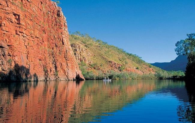
Chamberlain River
The Chamberlain River is a river in the Kimberley region of Western Australia. The headwaters of the river rise in the Durack Range near Yulumbu. The river flows in a northerly direction along the range until it merges with the Pentecost River near El Questro Station. El Questro Wilderness Park has an abundance of activities and adventures, That need a reasonable level of fitness. A river cruise along the Chamberlain River to explore the Chamberlain Gorge is the best activity, take a photo of the river and its wildlife, including a saltwater crocodile basking on the riverbank.
When to Visit Kimberley Australia
The Kimberley landscape is radiant with new growth and freshwater swimming places are filled with gushing waterfalls. March is the best month to start the Kimberley cruising season when waterfalls are at their most magnificent after seasonal rains. Many waterfalls flow year-round but the best time to witness the Kimberley waterfall spectacle is generally from March to early June.


