The Great Boundary Fault
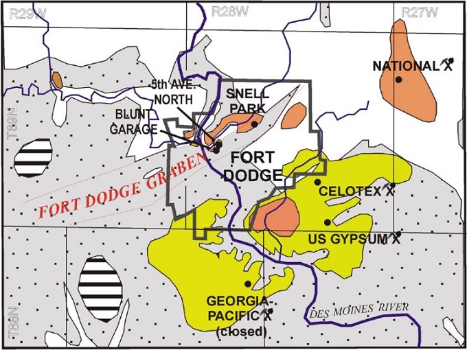
The great boundary fault in Rajasthan is a major tectonic lineament in the south-eastern Rajasthan along the Bundi-Sawaimadhopur hills. It separates the Aravalli and the Vindhyan. It is extended over Chittorgarh in the south, Bundi and Sawai Madhopur (Machilpur) in the north, and has a strike length of about 400 km. The Great Boundary Fault Zone contains different types of fault rocks, ductile shear zones, and multiple sets of fractures and faults.
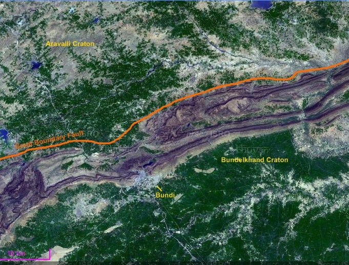
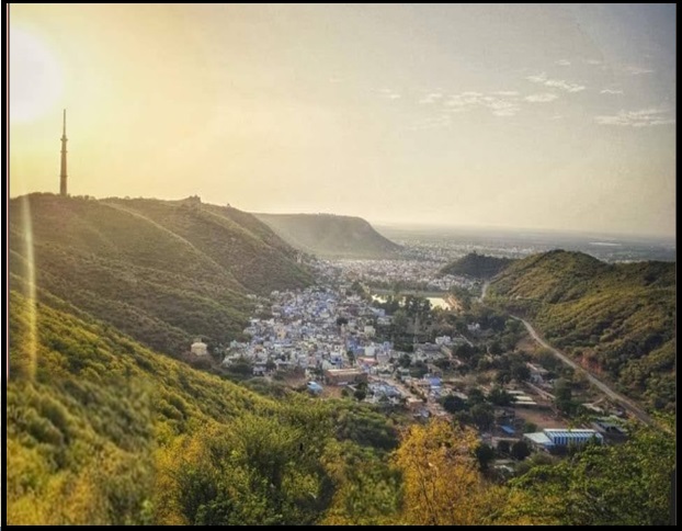
The Great Boundary Fault at Satur, Bundi district in Rajasthan is represents a zone of disruption constituted by several parallel and oblique faults resulting in a step-like feature. The deformed limestone at the site is worth viewing. The Great Boundary Fault is best studied at about 10 km NW of Bundi on Jaipur Road.
Geology
Geologically, the area consists of diverse rock types belonging to the oldest Archean metamorphites of the Bhilwara Supergroup and the Upper Proterozoic sedimentaries of the Vindhyan Supergroup. The NE-SW part of the district is exposed by the rock types belonging to the Bhilwara Supergroup, and in the remaining part, rock types of the Vindhyan Supergroup exist.
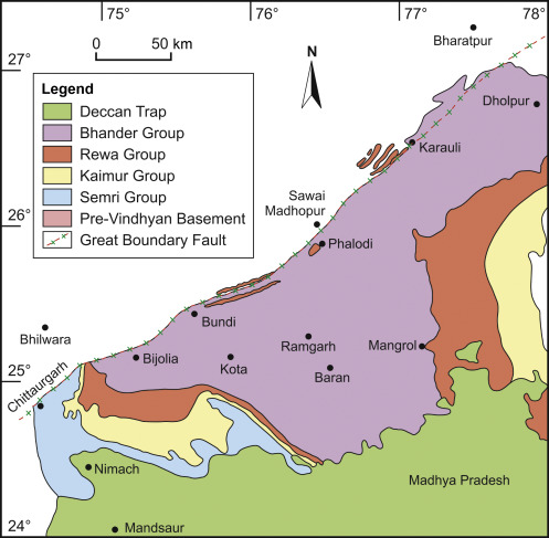
Vindhyan sedimentary sequences have occupied the northeastern to the southern part of the Bundi district. These are grouped as the Upper Vindhyan Supergroup and separated from the Bhilwara Supergroup by a major reverse fault known as the Great Boundary Fault. All three Kaimur, Rewa & Bhander Groups with their formations & members are well exposed.
Also read- Eparchaean Unconformity: The 500 Million Year Mystery in Time Scale
Rocks of the Kaimur Group occur as an outlier on the NW of the Great Boundary fault in between the Bundi Indergarh area. Rewa Group comprises Panna shales, Indergarh (Lower Rewa) sandstone, Jhiri shale, and Ganurgarh (Upper Rewa) sandstone formations.
Tectonic History of the Great Boundary Fault, Rajasthan
The Great Boundary Fault (GBF) in Rajasthan originated as a pre-Vindhyan thrust, later evolving into a normal fault that controlled the margin of the Vindhyan basin. It was reactivated during the Vindhyan sedimentation and deformation, and its present reverse geometry with thrusting indicates later tectonic activity. Its history involves both pre-Vindhyan and post-Vindhyan faulting, with evidence suggesting reactivation even during the Himalayan orogeny, making it an active zone with a complex tectonic history.
Fault Rock Analysis, Great Boundary Fault Zone
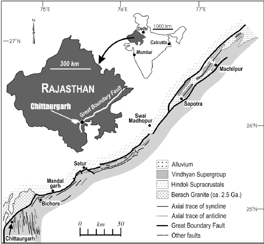
The Great Boundary Fault is a major tectonic lineament in northwestern India that runs close to the contact between the Vindhyan sedimentary rocks (ca. 1400-600 Ma) and the Aravalli supergroup. In Chittaurgarh, an area where the Vindhyan sedimentary rocks occur on the footwall, well-developed fault zones and fault-related deformation zones are present. In contrast, the Berach granite (ca. 2500 Ma), located on the hanging-wall side, does not exhibit any significant imprints of fault-related deformation.
The nature of the fault rocks within the Great Boundary Fault Zone is highly variable. Both cataclasite and mylonite are commonly developed in the relatively competent lithounit caught up within the fault zone. Fault breccia is relatively less common.
The breccia/cataclasite and the mylonite have developed in alternate cycles, and the brittle deformation has acted as the precursor to the ductile deformation. The Great Boundary Fault Zone has, in general, developed in a brittle-ductile transitional zone. It is concluded that the Great Boundary Fault zone has a characteristic deformation style, which is defined by the development of ductile shear zones.
Also read- Business leaders’ success story
Both the basement and the Vindhyan sediments occurring on the hanging wall side of the fault have been folded into large-scale low-plunging folds trending parallel to the GBF. An increase in tightness and asymmetry of the folds near the fault suggests that these are fault-related folds.
Geological significance of the Great Boundary Fault
The Great Boundary Fault (GBF) is a major tectonic lineament in southeastern Rajasthan, marking the boundary of the Vindhyan basin by separating the Aravalli and Vindhyan rocks. Geologically, it represents a zone of significant structural discontinuity, containing fault rocks and ductile shear zones. Its reactivation has been crucial, influencing both sedimentation and deformation and thus providing a record of past tectonic and seismic activity in the region.
Acting as the northern and western limit of the Vindhyan basin, the fault originated before Vindhyan sedimentation but was subsequently reactivated during and after it. This complex fault zone is characterized by diverse structural features, including various fault rocks, ductile shear zones, and multiple fractures, which record a long history of deformation. Furthermore, the GBF is critical for understanding resource creation, as it affects the distribution of rock and mineral deposits. Geologists also study the fault’s history to comprehend past seismic activity and tectonic plate movement, which is essential for predicting future geological events in the area.
Best place to see a complete section of the Great Boundary Fault
The area around the Chittorgarh town is known for having one of the best and most complete exposed sections of the Great Boundary Fault in Rajasthan. The Berach river section near Chittorgarh is a key location for observing deformation along the Great Boundary Fault (GBF), a major geological feature that separates the ancient Berach granite from the younger Vindhyan sedimentary rocks. The fault zone, a complex area of tectonic activity, has caused ductile shearing and other fault-related structures like folds and shear zones to develop within the sedimentary rocks. The Berach River cuts through the Vindhyan rocks, exposing these features and providing a site for geological study.


