Diana’s Punchbowl
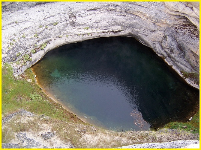
Diana’s Punchbowl, also known as the Devil’s Cauldron, is a striking geothermal feature located on a small fault in Nye County, Nevada. The hot spring is exposed within a cup-shaped depression, approximately 15 m. in diameter, set atop a 180 m. domelike hill of travertine. The hot water pool sits about 9 m below the rim of the bowl.
Geography
Diana’s Punchbowl, also known as the Devil’s Cauldron, is a prominent geothermal feature located in the geothermally active Great Basin near the geographic center of Nevada. Situated in the Monitor Valley of Nye County, it lies about 30 miles southeast of Austin and just east of Monitor Valley Road, 9 miles south of Monitor Ranch.
This feature consists of a travertine hill topped by a bowl that measures 50 feet across and 30 feet deep. The water in the spring is extremely hot, estimated at 93 °C. The hot mineral water flows into a creek, where it cools to approximately 100 °F at the far end, forming several rock pools along its course.
Geology
Diana’s Punchbowl is a unique geothermal feature in Nevada, formed by a hot spring emerging through a travertine mound. The geology is a geothermal phenomenon where extremely hot mineral water flows up through a cup-shaped depression in a domelike hill of travertine, also known as the Devil’s Cauldron. It is a geothermal hot spring located on a small fault in Nevada’s Monitor Valley, emerging through a travertine mound.
Also read- Turquoise Dreams- A Guide to Nusa Lembongan Paradise
Tourism
Diana’s Punchbowl is a popular spot for relaxation and is surrounded by historical interest, including the nearby ghost town of Belmont and Toquima Cave. Toquima Cave is notable for its pictographs (cave drawings), which indicate human habitation between 1500 and 3000 years ago. My husband and I visited Diana’s Punchbowl during a ghost town vacation while staying in Belmont. The accompanying images are digital photos of old film pictures that have degraded over time.
How to Reach Diana’s Punchbowl
To reach Punchbowl, start from US-50, where you turn south onto the graded dirt Belmont Road (BLM 425 / Monitor Valley Road). This turnoff is located approximately 12.6 miles east of Hickson Summit and is usually passable for passenger cars in dry conditions. Continue for 33.8 miles, then take the primitive dirt road branching left. Diana’s Punchbowl—recognizable as a low gray mound in the valley—lies roughly one mile down this road, where a high-clearance vehicle is advised.
Also Read- Business Leaders Success Story


