
Cenotes Of Mexico
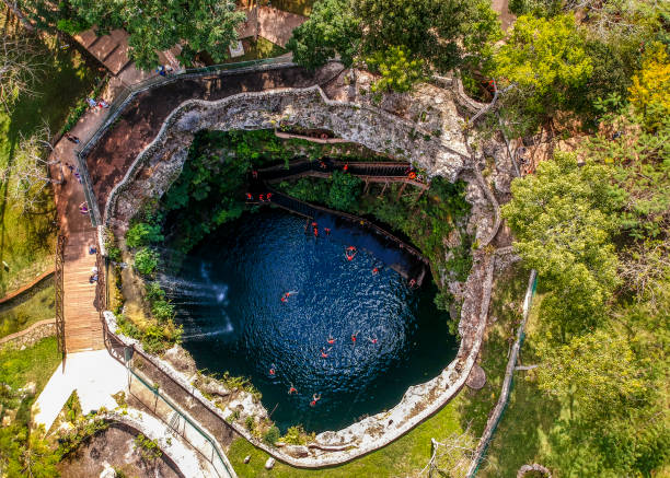
A cenote is a natural sinkhole filled with fresh water, created when the limestone bedrock of the Yucatán Peninsula collapsed into the groundwater below. Mexico’s Yucatán Peninsula, with its vast underground river systems, is the ideal location to discover and explore these fascinating formations. Cenotes are not only remarkable examples of nature’s power but also hold cultural significance for the Mayan people, who regarded them as sacred entrances to the underworld. Today, cenotes attract tourists of all ages, eager to experience the beauty and mystery of these natural wonders.
There are over 3,000 natural cenotes in Mexico, mostly located within the Chicxulub crater, which was formed by the meteorite impact that led to the extinction of the dinosaurs.
The word “cenote” comes from the Mayan word for “well.” Cenotes were vital to the development of the Mayan civilization as they served as the primary water source in the Yucatán Peninsula, where rivers and lakes are scarce. This is why many Mayan settlements, such as Chichen Itza and Tulum, were built near cenotes. The Mayans believed that cenotes were gateways to the underworld, and it’s easy to understand why. Diving into a cenote reveals a mysterious world of interconnected underground rivers, with stunning stalactites and stalagmites in the clear turquoise waters.
Many cenotes in the Yucatán contain remains of offerings to the gods. For example, the Sacred Cenote of Chichen Itza (Cenote Sagrado) was a site where the Mayans made offerings to Chac, the god of rain. Archaeological findings have recovered over fifty bodies of warriors and young virgins from its waters, along with gold jewelry. Today, cenotes are a popular tourist attraction in Mexico, drawing divers and explorers eager to experience their depths. While many cenotes are free to visit, some privately owned ones require an entrance fee.
Also Read- Turquoise Dreams- Embracing the Beauty of ‘Cancun Mexico’
Cenote
A cenote is a natural pit or sinkhole formed when limestone bedrock collapses, revealing the groundwater beneath. The term originated on Mexico’s Yucatán Peninsula, where cenotes were vital for the ancient Maya as water sources and occasionally for sacrificial offerings. The name comes from the Yucatec Maya word “tsʼonoʼot,” which refers to any place with accessible groundwater.
The Yucatán Peninsula in Mexico alone is estimated to have around 10,000 cenotes, naturally formed water-filled sinkholes scattered across the region. Some of these cenotes are currently threatened by the construction of the new tourist Maya Train.
Cenotes are common geological formations in low-altitude areas, especially on islands (like Cefalonia, Greece), coastlines, and regions with young post-Paleozoic limestone and minimal soil development. Although the term “cenote” originally described features specific to the Yucatán, researchers now use it to refer to similar karst formations found in places like Cuba, Australia, Europe, and the United States.
Geology
Cenotes are created when rock dissolves, forming a subsurface void that may or may not connect to an active cave system. This void leads to a structural collapse, where the fallen rock is gradually removed through further dissolution, allowing more space for additional collapses. The collapse rate often increases when the water table drops below the ceiling of the void, as the rock ceiling loses the support previously provided by the water.
Cenotes can be completely collapsed, forming an open water pool, or partially collapsed, with a portion of rock hanging over the water. The classic image of a cenote is a small, circular pond with steep rock walls, often tens of meters in diameter. However, many cenotes require some degree of stooping or crawling to reach the water.
Chicxulub crater
While cenotes are widely distributed across the Yucatán Peninsula, there is a higher density of them in a circular pattern that aligns with the measured rim of the Chicxulub crater. This crater was initially identified by the alignment of these cenotes, and it has since been mapped using geophysical methods like gravity mapping and confirmed through core drilling. The Chicxulub crater has been dated to the boundary between the Cretaceous and Paleogene periods, around 66 million years ago. The meteorite impact that created this crater is linked to the mass extinction event that wiped out the non-avian dinosaurs, known as the Cretaceous–Paleogene extinction event.
Other Example
Australia-Ewens Ponds, near Mount Gambier, South Australia, Kilsby sinkhole, near Mount Gambier, South Australia and Little Blue Lake, near Mount Schank, South Australia
Bahamas-Thunderball Grotto, on Staniel Cay
Belize- Great Blue Hole
Canada-Devil’s Bath is the largest cenote in Canada at a size of 359m in diameter and 44m in depth. It is located near the village of Port Alice, British Columbia on the northwest coastline of Vancouver Island. Devil’s Bath is continuously fed by an underground spring and is connected by an underwater tunnel to the Benson River Cave.
Dominican Republic- Hoyo Azul (Punta Cana), Los Tres Ojos and Ojos Indigenas (Punta Cana)


