Salina Canyon Unconformity, Utah
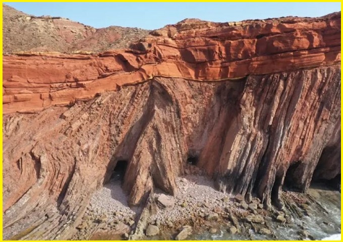
The Salina Canyon Unconformity in central Utah is a spectacular, world-class geological feature along Interstate 70, where nearly vertical, red Middle Jurassic Twist Gulch Formation is capped by horizontal Paleocene Flagstaff Formation. It represents over 107 million years of missing time caused by structural tilting and subsequent erosion, creating a dramatic angular discordance visible on the northern side of the highway.
This geological feature is visible throughout the lower sections of Salina Canyon, within the Salina Creek valley, east of the town of Salina. It can be observed on both sides of Interstate 70, though it is more prominently exposed on the northern side of the highway. The underlying rock layers gradually become less steeply inclined, eventually transitioning into a disconformable relationship with the overlying strata.
Angular Unconformity
Angular unconformities form when originally horizontal sedimentary layers are tilted by tectonic forces, then eroded, and later overlain by new, flat-lying sedimentary deposits. The Salina Canyon example is especially dramatic, with horizontal strata resting directly atop nearly vertical layers, separated by an uneven erosional surface marked by small-scale irregularities.
Also read- Geotourism And Modern Geotechniques
The Salina Canyon angular unconformity features reddish, near-vertical strata beneath the contact belonging to the Twist Gulch Formation (Middle Jurassic). Above the contact, lighter-colored, horizontally layered rocks include a thin section of the Flagstaff Formation (mid-Paleocene), along with the Colton Formation and the Green River Formation (upper Paleocene to Eocene).
Geology
The Salina Canyon angular unconformity displays reddish, steeply inclined beds of the Twist Gulch Formation (Middle Jurassic) below the contact, composed mainly of siltstone, sandstone, and shale. Above the contact lie whitish, horizontally bedded sandstones of the Flagstaff Formation (mid-Paleocene). Notably, rare halite salt casts—an unusual sedimentary structure—can be observed on some bedding planes within the Twist Gulch Formation at this site.
The tilting of the Twist Gulch strata in Salina Canyon is attributed to localized salt dome tectonics. Evaporite deposits occur in the underlying Arapien Formation (Middle Jurassic), where rock salt layers have risen upward as salt diapirs, deforming and tilting the overlying rocks. This angular unconformity helps constrain the timing of Arapien salt diapirism to between the Jurassic and Paleocene periods—most likely during the Cretaceous.
Also read- Upheaval Dome: Stunning Crater, Synclines, and Ancient Rock
How to Reach Salina Canyon Unconformity
The Salina Canyon Unconformity is a prominent geologic feature located in Sevier County, Utah, along Interstate 70 (I-70), roughly 2.4 to 4.8 miles east of Salina. The most accessible and clear views are along I-70, with prominent exposures identified near stations, such as the area near the old copper mine.


