The Chota Nagpur Plateau: A Geological and Cultural Treasure
Chota Nagpur Plateau
The Chota Nagpur Plateau, located in eastern India, spans much of Jharkhand and extends into neighboring regions of Chhattisgarh, Odisha, West Bengal, and Bihar. Bordered by the Indo-Gangetic Plain to the north and east and the Mahanadi River basin to the south, the plateau covers an area of approximately 65,000 square kilometers. Chota Nagpur Plateau is probably the world’s largest collection of megaliths, spread over 53 known sites.
Geology
The Chota Nagpur Plateau is a continental plateau, characterized by an extensive landmass uplifted above the surrounding terrain. Composed of Precambrian rocks over 540 million years old, the plateau was shaped during the Cenozoic era through tectonic-driven continental uplift. Its ancient origins are evidenced by Gondwana substrates, linking it to the Deccan Plate, which separated from the southern supercontinent during the Cretaceous period. This plate embarked on a 50-million-year drift before colliding with the Eurasian continent, with the northeastern Deccan Plateau, including this ecoregion, marking the initial point of contact. The region’s geological history features prolonged episodes of metamorphism, granitic activity, and igneous intrusions spanning from over 1,000 million years ago to about 185 million years ago.
Division
The Chota Nagpur Plateau is divided into three distinct steps. The highest step is located in the western part of the plateau, where local plateaus, known as pats, rise to elevations of 910 to 1,070 meters above sea level, with the highest point reaching 1,164 meters. The middle step includes much of the old Ranchi and Hazaribagh districts, as well as parts of the former Palamu district before it was divided into smaller administrative units. The average elevation in this region is around 610 meters, and the topography is undulating, with prominent gneissic hills, often dome-shaped. The lowest step, at about 300 meters, covers the former Manbhum and Singhbhum districts. This section features high hills, such as Parasnath Hills, which rise to 1,370 meters, and Dalma Hills, reaching 1,038 meters. The large plateau is further subdivided into several smaller plateaus or sub-plateaus.
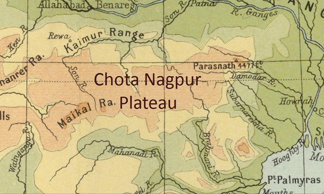
Chota Nagpur Plateau in India Map
Chota Nagpur, the plateau in eastern India, in northwestern Chhattisgarh and central Jharkhand states. The plateau is composed of Precambrian rocks.
Chota Nagpur Plateau Weather
Highest Peak of Chota Nagpur Plateau
Mineral Resources
The Chota Nagpur Plateau is a rich repository of mineral resources, including mica, bauxite, copper, limestone, iron ore, and coal. The Damodar Valley, in particular, is known for its abundant coal reserves and is regarded as the primary center for coking coal in India. Extensive coal deposits are located in the central basin, covering an area of 2,883 square kilometers (1,113 square miles). Key coalfields in the region include Jharia, Raniganj, West Bokaro, East Bokaro, Ramgarh, South Karanpura, and North Karanpura.
Fossil record
